
FCCInfo.com
A Service of Cavell, Mertz & Associates, Inc.
(855) FCC-INFO
|
|
K19FF-D from 01/09/2003 |
|
|
||||||||||||||||
|
|
Status: License Application Accepted: 07/14/2021 License Expires: 04/01/2022 File Number: -0000152876 FCC Website Links: LMS Facility Details This Application Other K19FF-D Applications Including Superseded Applications Mailing Address Correspondence for K19FF-D Correspondence related to application -0000152876 Service Contour - Open Street Map or USGS Map (51 dBu) Service Contour - KML / Google Earth (51 dBu) Rabbit Ears Info Search for K19FF-D Site Location: 46-26-08.5 N 105-50-54.8 W (NAD 83) Site Location: 46-26-08.5 N 105-50-52.8 W (Converted to NAD 27) ERP: 15 kW Polarization: Horizontally polarized R/C AGL: 27.4 m (90 ft.) R/C AMSL: 826 m (2710 ft.) Emission Mask: Stringent Site Elevation: 798.6 m. (2620 ft.) Height Overall*: 30.5 m (100 ft.) (* As Filed In This Application, may differ from ASR Data, Below.) Directional Antenna - Antenna Make/Model: Andrew ALP8M1-HSE Antenna ID: 39374 Polarization: Horizontally polarized
| ||||||||||||||||||
| Antenna Data for Antenna Id: 39374 K19FF-D LD File: -0000152876 Andrew - ALP8M1-HSE Service: LD Standard Pattern: Y Pattern and Field Values Include a 141° Clockwise Rotation | 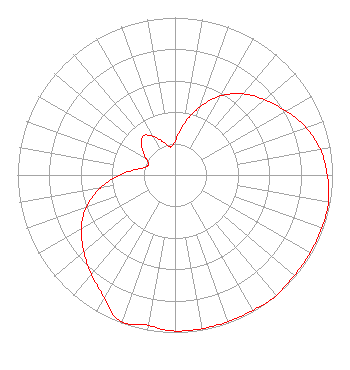 | ||||||||||||||||||
| Azimuth | Ratio | Azimuth | Ratio | Azimuth | Ratio | Azimuth | Ratio | ||||||||||||
| 1 | 0.220 | 11 | 0.340 | 21 | 0.470 | 31 | 0.590 | ||||||||||||
| 41 | 0.680 | 51 | 0.750 | 61 | 0.820 | 71 | 0.890 | ||||||||||||
| 81 | 0.940 | 91 | 0.970 | 101 | 0.990 | 111 | 0.990 | ||||||||||||
| 121 | 0.990 | 131 | 0.990 | 141 | 1.000 | 151 | 0.990 | ||||||||||||
| 161 | 0.990 | 171 | 0.990 | 181 | 0.990 | 191 | 0.970 | ||||||||||||
| 201 | 0.990 | 211 | 0.890 | 221 | 0.820 | 231 | 0.750 | ||||||||||||
| 241 | 0.680 | 251 | 0.590 | 261 | 0.470 | 271 | 0.340 | ||||||||||||
| 281 | 0.220 | 291 | 0.180 | 301 | 0.220 | 311 | 0.280 | ||||||||||||
| 321 | 0.320 | 331 | 0.280 | 341 | 0.220 | 351 | 0.180 | ||||||||||||
Structure Registration Number 1213896 Structure Type: MAST Registered To: Nexstar Media Inc. Structure Address: Yellowstone Hill, Approximately One Mile North Of Miles City, Mt Miles City, MT County Name: Custer County ASR Issued: 05/28/2021 Date Built: 06/23/2000 Site Elevation: 798.6 m (2620 ft.) Structure Height: 30.1 m (99 ft.) Height Overall: 30.5 m (100 ft.) Overall Height AMSL: 829.1 m (2720 ft.) FAA Determination: 04/27/2000 FAA Study #: 00-ANM-0089-OE FAA Circular #: 70/7460-1K Paint & Light FAA Chapters: 4, 5, 12 Removed expiration date from determination. Scenario 1./jjs/case#635066 46-26-08.5 N 105-50-54.8 W (NAD 83) 46-26-08.5 N 105-50-52.8 W (Converted to NAD 27) |
545 E. John Carpenter Freeway Suite 700 Irving, TX 75062 Phone: 972-373-8800 Corporation | Title: General Counsel Date: 07/14/2021 Application Certifier Nexstar Media Inc. 545 E. John Carpenter Freeway Suite 700 Irving, TX 75062 Applicant Elizabeth Ryder Nexstar Media Inc. 545 E. John Carpenter Freeway Suite 700 Irving, TX 75062 General Counsel | |||||||||||||||||