
FCCInfo.com
A Service of Cavell, Mertz & Associates, Inc.
(855) FCC-INFO
|
|
|
|
|
||||||||||||||||
|
|
Status: License Application Accepted: 07/21/2021 License Expires: 06/01/2029 File Number: -0000153504 FCC Website Links: LMS Facility Details This Application Other WLHA-LD Applications Including Superseded Applications Mailing Address Correspondence for WLHA-LD Correspondence related to application -0000153504 Service Contour - Open Street Map or USGS Map (51 dBu) Service Contour - KML / Google Earth (51 dBu) Rabbit Ears Info Search for WLHA-LD Site Location: 31-27-13.0 N 89-17-05.0 W (NAD 83) Site Location: 31-27-12.4 N 89-17-04.8 W (Converted to NAD 27) ERP: 15 kW Polarization: Elliptically polarized Electrical Beam Tilt: 0.5 degrees R/C AGL: 146.3 m (480 ft.) R/C AMSL: 201.7 m (662 ft.) Emission Mask: Full Service Site Elevation: 55.4 m. (182 ft.) Height Overall*: 175.8 m (577 ft.) (* As Filed In This Application, may differ from ASR Data, Below.) Directional Antenna - Antenna Make/Model: Dielectric TLP-8H/VP Antenna ID: 1008468 Polarization: Elliptically polarized | ||||||||||||||||||
| Antenna Data for Antenna Id: 1008468 WLHA-LD LD File: -0000153504 Dielectric - TLP-8H/VP Service: LD Standard Pattern: N Pattern and Field Values Include a 110° Clockwise Rotation | 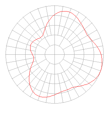 | ||||||||||||||||||
| Azimuth | Ratio | Azimuth | Ratio | Azimuth | Ratio | Azimuth | Ratio | ||||||||||||
| 0 | 0.810 | 10 | 0.891 | 20 | 0.918 | 30 | 0.885 | ||||||||||||
| 40 | 0.834 | 50 | 0.793 | 60 | 0.777 | 70 | 0.816 | ||||||||||||
| 80 | 0.885 | 90 | 0.949 | 100 | 0.984 | 110 | 1.000 | ||||||||||||
| 120 | 0.977 | 130 | 0.917 | 140 | 0.842 | 150 | 0.776 | ||||||||||||
| 160 | 0.768 | 170 | 0.779 | 180 | 0.828 | 190 | 0.885 | ||||||||||||
| 200 | 0.911 | 210 | 0.880 | 220 | 0.788 | 230 | 0.673 | ||||||||||||
| 240 | 0.560 | 250 | 0.467 | 260 | 0.430 | 270 | 0.452 | ||||||||||||
| 280 | 0.495 | 290 | 0.521 | 300 | 0.511 | 310 | 0.477 | ||||||||||||
| 320 | 0.446 | 330 | 0.468 | 340 | 0.560 | 350 | 0.688 | ||||||||||||
Structure Registration Number 1046930 Structure Type: Registered To: Gray Media Group, Inc. Structure Address: 1.93 Km Hwy 11 N Eastabutchie, MS County Name: Jones County ASR Issued: 02/11/2019 Date Built: 01/01/1962 Site Elevation: 55.4 m (182 ft.) Structure Height: 152.4 m (500 ft.) Height Overall: 175.8 m (577 ft.) Overall Height AMSL: 231.2 m (759 ft.) FAA Determination: 06/10/1998 FAA Study #: 98-ASO-2649-OE Paint & Light FAA Chapters: 1, 3, 4, 13, 21 31-27-13.0 N 89-17-05.0 W (NAD 83) 31-27-12.4 N 89-17-04.8 W (Converted to NAD 27) |
4370 Peachtree Road, Ne Atlanta, GA 30319 Phone: 202-750-1585 Limited Liability Company | Title: Manager Date: 07/21/2021 Application Certifier Lowcountry 34 Media, Llc 14 Tuxedo Drive Beaufort, SC 29907 Applicant Davina Sashkin, Esq Baker & Hostetler Llp 1050 Connecticut Avenue, Nw Suite 1100 Washington, DC 20036 | |||||||||||||||||