
FCCInfo.com
A Service of Cavell, Mertz & Associates, Inc.
(855) FCC-INFO
|
|
|
|
|
||||||||||||||||
|
|
Status: License Application Accepted: 07/28/2021 License Expires: 08/01/2029 File Number: -0000154432 FCC Website Links: LMS Facility Details This Application Other WNSH-LD Applications Including Superseded Applications Mailing Address Correspondence for WNSH-LD Correspondence related to application -0000154432 Service Contour - Open Street Map or USGS Map (48 dBu) Service Contour - KML / Google Earth (48 dBu) Rabbit Ears Info Search for WNSH-LD Site Location: 36-10-37.3 N 86-46-41.2 W (NAD 83) Site Location: 36-10-37.1 N 86-46-41.2 W (Converted to NAD 27) ERP: 3 kW Polarization: Horizontally polarized R/C AGL: 133.8 m (439 ft.) R/C AMSL: 260 m (853 ft.) Emission Mask: Full Service Site Elevation: 126.2 m. (414 ft.) Height Overall*: 152.4 m (500 ft.) (* As Filed In This Application, may differ from ASR Data, Below.) Directional Antenna - Antenna Make/Model: Propagation System Inc PSIVLP2EC2 Antenna ID: 91720 Polarization: Horizontally polarized | ||||||||||||||||||
| Antenna Data for Antenna Id: 91720 WNSH-LD LD File: -0000154432 Propagation System Inc - PSIVLP2EC2 Service: LD Standard Pattern: Y Pattern and Field Values Include a 310° Clockwise Rotation | 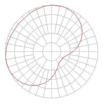 | ||||||||||||||||||
| Azimuth | Ratio | Azimuth | Ratio | Azimuth | Ratio | Azimuth | Ratio | ||||||||||||
| 0 | 1.000 | 10 | 0.999 | 20 | 0.985 | 30 | 0.955 | ||||||||||||
| 40 | 0.905 | 50 | 0.843 | 60 | 0.761 | 70 | 0.669 | ||||||||||||
| 80 | 0.566 | 90 | 0.462 | 100 | 0.372 | 110 | 0.310 | ||||||||||||
| 120 | 0.281 | 130 | 0.284 | 140 | 0.281 | 150 | 0.310 | ||||||||||||
| 160 | 0.372 | 170 | 0.462 | 180 | 0.566 | 190 | 0.669 | ||||||||||||
| 200 | 0.761 | 210 | 0.843 | 220 | 0.905 | 230 | 0.955 | ||||||||||||
| 240 | 0.985 | 250 | 0.999 | 260 | 1.000 | 270 | 0.982 | ||||||||||||
| 280 | 0.963 | 290 | 0.943 | 300 | 0.926 | 310 | 0.929 | ||||||||||||
| 320 | 0.926 | 330 | 0.943 | 340 | 0.963 | 350 | 0.982 | ||||||||||||
Structure Registration Number 1223919 Structure Type: LTOWER Registered To: Subcarrier Communications Inc Structure Address: 19 Oldham Street Nashville, TN County Name: Davidson County ASR Issued: 06/22/2017 Date Built: 06/22/2017 Site Elevation: 126.2 m (414 ft.) Structure Height: 144.8 m (475 ft.) Height Overall: 152.4 m (500 ft.) Overall Height AMSL: 278.6 m (914 ft.) FAA Determination: 06/08/2017 FAA Study #: 2017-ASO-11194-OE FAA Circular #: 70/7460-1L Paint & Light FAA Chapters: 4, 8, 12 PRIOR STUDY 2000-ASO-2123-OE 36-10-37.3 N 86-46-41.2 W (NAD 83) 36-10-37.1 N 86-46-41.2 W (Converted to NAD 27) |
Salisbury, MD 21803 Phone: 301-661-9611 Corporation | Title: Manager Date: 07/28/2021 Application Certifier Lowcountry 34 Media, Llc 14 Tuxedo Drive Beaufort, SC 29907 Applicant Darryl K DeLawder Delawder Communications, Inc. P.o. Box 1095 Ashburn, VA 20146 President Davina Sashkin, Esq Baker & Hostetler Llp 1050 Connecticut Avenue, Nw Suite 1100 Washington, DC 20036 | |||||||||||||||||