
FCCInfo.com
A Service of Cavell, Mertz & Associates, Inc.
(855) FCC-INFO
|
|
WWAT-CD from 02/06/2002 WWAT-CD from 10/30/1990 |
Post-repack Channel 29 |
|
||||||||||||||||
|
|
Repacking Information: Pre-Repack Channel: 45 Post-Repack Channel: 29 Post-Repack ERP: 0.407 kW Phase: 4 Completion Deadline: 8/2/2019 Find nearby TV Facilities Status: Construction Permit Application Accepted: 08/02/2021 WWAT-CD CP Expires: 08/03/2024 File Number: -0000155811 FCC Website Links: LMS Facility Details This Application Other WWAT-CD Applications Including Superseded Applications Mailing Address Correspondence for WWAT-CD Correspondence related to application -0000155811 Service Contour - Open Street Map or USGS Map (51 dBu) Service Contour - KML / Google Earth (51 dBu) Public Inspection Files Rabbit Ears Info Search for WWAT-CD Site Location: 40-26-46.2 N 79-57-50.2 W (NAD 83) Site Location: 40-26-46.0 N 79-57-51.0 W (Converted to NAD 27) ERP: 15 kW Polarization: Circularly polarized R/C AGL: 102.1 m (335 ft.) R/C AMSL: 457.1 m (1500 ft.) Emission Mask: Full Service Site Elevation: 355 m. (1165 ft.) Height Overall*: 181.1 m (594 ft.) (* As Filed In This Application, may differ from ASR Data, Below.) Directional Antenna - Antenna Make/Model: ALIVE ATC-BCC48C1R-V0-29 Antenna ID: 1008517 Polarization: Circularly polarized | ||||||||||||||||||
| Antenna Data for Antenna Id: 1008517 WWAT-CD DC File: -0000155811 ALIVE - ATC-BCC48C1R-V0-29 Service: DC Standard Pattern: N Pattern and Field Values Include a 145° Clockwise Rotation | 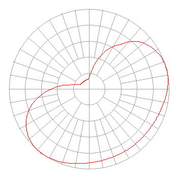 | ||||||||||||||||||
| Azimuth | Ratio | Azimuth | Ratio | Azimuth | Ratio | Azimuth | Ratio | ||||||||||||
| 5 | 0.185 | 15 | 0.354 | 25 | 0.538 | 35 | 0.681 | ||||||||||||
| 45 | 0.838 | 55 | 0.929 | 65 | 0.981 | 75 | 0.998 | ||||||||||||
| 77 | 1.000 | 85 | 0.990 | 95 | 0.966 | 105 | 0.939 | ||||||||||||
| 115 | 0.919 | 125 | 0.907 | 135 | 0.901 | 145 | 0.899 | ||||||||||||
| 155 | 0.900 | 165 | 0.904 | 175 | 0.916 | 185 | 0.935 | ||||||||||||
| 195 | 0.961 | 205 | 0.986 | 215 | 0.999 | 217 | 1.000 | ||||||||||||
| 225 | 0.988 | 235 | 0.943 | 245 | 0.859 | 255 | 0.733 | ||||||||||||
| 265 | 0.561 | 275 | 0.377 | 285 | 0.200 | 295 | 0.128 | ||||||||||||
| 305 | 0.118 | 315 | 0.115 | 325 | 0.110 | 335 | 0.115 | ||||||||||||
| 345 | 0.118 | 355 | 0.124 | ||||||||||||||||
Structure Registration Number 1022324 Structure Type: LTOWER Registered To: WQED Multimedia Structure Address: 3801 University Drive Pittsburgh, PA County Name: Allegheny County ASR Issued: 10/10/2023 Date Built: 07/01/2019 Site Elevation: 355 m (1165 ft.) Structure Height: 157.3 m (516 ft.) Height Overall: 181.1 m (594 ft.) Overall Height AMSL: 536.1 m (1759 ft.) FAA Determination: 05/10/2017 FAA Study #: 2017-AEA-3459-OE FAA Circular #: 70/7460-1J Paint & Light FAA Chapters: 3, 4, 5, 13 OM&L to remain the same as prior study = PAINT/RED LIGHTS 40-26-46.2 N 79-57-50.2 W (NAD 83) 40-26-46.0 N 79-57-51.0 W (Converted to NAD 27) |
975 Greentree Rd. Pittsburgh, PA 15220 Phone: 412-921-7577 Limited Liability Company | Title: Manager Date: 08/02/2021 Application Certifier Fifth Street Enterprises, Llc 975 Greentree Rd. Pittsburgh, PA 15220 Applicant Joan Stewart Wiley Rein Llp 1776 K Street, Nw Washington, DC 20006 Ron Bruno Fifth Street Enterprises 975 Greentree Rd Pittsburgh, PA 15220 Lawrence Rogow Fifth Street Enterprises, Llc 5670 Wilshire Blvd., Suite 1620 Los Angeles, CA 90036 | |||||||||||||||||