
FCCInfo.com
A Service of Cavell, Mertz & Associates, Inc.
(855) FCC-INFO
|
|
KTLE-LD from 01/17/2002 KTLE-LD from 08/23/1989 |
|
|
||||||||||||||||
|
|
Status: License Application Accepted: 08/19/2021 License Expires: 08/01/2022 File Number: -0000157634 FCC Website Links: LMS Facility Details This Application Other KTLE-LD Applications Including Superseded Applications Mailing Address Correspondence for KTLE-LD Correspondence related to application -0000157634 Service Contour - Open Street Map or USGS Map (51 dBu) Service Contour - KML / Google Earth (51 dBu) Rabbit Ears Info Search for KTLE-LD Site Location: 31-53-50.3 N 102-20-15.5 W (NAD 83) Site Location: 31-53-49.9 N 102-20-14.0 W (Converted to NAD 27) ERP: 15 kW Polarization: Horizontally polarized Electrical Beam Tilt: 0.5 degrees R/C AGL: 99 m (325 ft.) R/C AMSL: 988.3 m (3242 ft.) Emission Mask: Full Service Site Elevation: 889.3 m. (2918 ft.) Height Overall*: 112.1 m (368 ft.) (* As Filed In This Application, may differ from ASR Data, Below.) Directional Antenna - Antenna Make/Model: Electronics Research Inc. ALP12L2-HSOC-203 Antenna ID: 1008097 Polarization: Horizontally polarized | ||||||||||||||||||
| Antenna Data for Antenna Id: 1008097 KTLE-LD LD File: -0000157634 Electronics Research Inc. - ALP12L2-HSOC-203 Service: LD Standard Pattern: N | 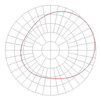 | ||||||||||||||||||
| Azimuth | Ratio | Azimuth | Ratio | Azimuth | Ratio | Azimuth | Ratio | ||||||||||||
| 0 | 0.814 | 10 | 0.865 | 20 | 0.908 | 30 | 0.943 | ||||||||||||
| 40 | 0.970 | 50 | 0.989 | 60 | 0.999 | 65 | 1.000 | ||||||||||||
| 70 | 0.999 | 80 | 0.989 | 90 | 0.970 | 100 | 0.943 | ||||||||||||
| 110 | 0.908 | 120 | 0.865 | 130 | 0.814 | 140 | 0.762 | ||||||||||||
| 150 | 0.715 | 160 | 0.673 | 170 | 0.643 | 180 | 0.626 | ||||||||||||
| 190 | 0.621 | 200 | 0.628 | 210 | 0.639 | 220 | 0.652 | ||||||||||||
| 230 | 0.662 | 240 | 0.667 | 250 | 0.667 | 260 | 0.662 | ||||||||||||
| 270 | 0.652 | 280 | 0.639 | 290 | 0.628 | 300 | 0.621 | ||||||||||||
| 310 | 0.626 | 320 | 0.643 | 330 | 0.673 | 340 | 0.715 | ||||||||||||
| 350 | 0.762 | ||||||||||||||||||
Structure Registration Number 1215312 Structure Type: MAST Registered To: Gray Media Group, Inc. Structure Address: 4101 E. 42nd Street Odessa, TX County Name: Ector County ASR Issued: 09/09/2020 Date Built: 12/23/2000 Site Elevation: 889.3 m (2918 ft.) Structure Height: 106.7 m (350 ft.) Height Overall: 112.1 m (368 ft.) Overall Height AMSL: 1001.4 m (3285 ft.) FAA Determination: 03/06/2007 FAA Study #: 2007-ASW-590-OE FAA Circular #: 70/7460-1K Paint & Light FAA Chapters: 4, 8, 12 OM&L to remain the same as prior study = A MED-DUAL SYSTEM 31-53-50.3 N 102-20-15.5 W (NAD 83) 31-53-49.9 N 102-20-14.0 W (Converted to NAD 27) |
4370 Peachtree Road, Ne Atlanta, GA 30319 Phone: 404-504-9828 Limited Liability Company | Title: Assistant Secretary Date: 08/19/2021 Application Certifier Gray Television Licensee, Llc 4370 Peachtree Road, Ne Atlanta, GA 30319 Applicant Joseph M. Davis, P.E. Chesapeake Rf Consultants, Llc 207 Old Dominion Road Yorktown, VA 23692 Consulting Engineer Joan Stewart Wiley Rein Llp 1776 K Street, Nw Washington, DC 20006 | |||||||||||||||||