
FCCInfo.com
A Service of Cavell, Mertz & Associates, Inc.
(855) FCC-INFO
|
|
|
|
|
||||||||||||||||
|
|
Status: Construction Permit Application Accepted: 09/07/2021 WOHW-LD CP Expires: 03/03/2024 File Number: -0000158622 FCC Website Links: LMS Facility Details This Application Other WOHW-LD Applications Including Superseded Applications Mailing Address Correspondence for WOHW-LD Correspondence related to application -0000158622 Service Contour - Open Street Map or USGS Map (51 dBu) Service Contour - KML / Google Earth (51 dBu) Rabbit Ears Info Search for WOHW-LD Site Location: 40-33-48.0 N 84-34-42.0 W (NAD 83) Site Location: 40-33-47.8 N 84-34-42.2 W (Converted to NAD 27) ERP: 15 kW Polarization: Elliptically polarized Electrical Beam Tilt: 1.0 degree R/C AGL: 113.7 m (373 ft.) R/C AMSL: 383.5 m (1258 ft.) Emission Mask: Full Service Site Elevation: 269.8 m. (885 ft.) Height Overall*: 152.4 m (500 ft.) (* As Filed In This Application, may differ from ASR Data, Below.) Directional Antenna - Antenna Make/Model: DIELECTRIC TLP-16B/VP Antenna ID: 1008649 Polarization: Elliptically polarized | ||||||||||||||||||
| Antenna Data for Antenna Id: 1008649 WOHW-LD LD File: -0000158622 DIELECTRIC - TLP-16B/VP Service: LD Standard Pattern: N Pattern and Field Values Include a 300° Clockwise Rotation | 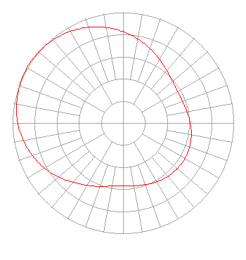 | ||||||||||||||||||
| Azimuth | Ratio | Azimuth | Ratio | Azimuth | Ratio | Azimuth | Ratio | ||||||||||||
| 0 | 0.826 | 10 | 0.771 | 20 | 0.715 | 30 | 0.661 | ||||||||||||
| 40 | 0.615 | 50 | 0.583 | 60 | 0.569 | 70 | 0.571 | ||||||||||||
| 80 | 0.586 | 90 | 0.607 | 100 | 0.627 | 110 | 0.640 | ||||||||||||
| 120 | 0.645 | 130 | 0.641 | 140 | 0.631 | 150 | 0.614 | ||||||||||||
| 160 | 0.592 | 170 | 0.579 | 180 | 0.570 | 190 | 0.579 | ||||||||||||
| 200 | 0.610 | 210 | 0.650 | 220 | 0.699 | 230 | 0.759 | ||||||||||||
| 240 | 0.818 | 250 | 0.869 | 260 | 0.915 | 270 | 0.951 | ||||||||||||
| 280 | 0.975 | 290 | 0.993 | 300 | 1.000 | 310 | 0.996 | ||||||||||||
| 320 | 0.981 | 330 | 0.955 | 340 | 0.920 | 350 | 0.876 | ||||||||||||
Structure Registration Number 1312117 Structure Type: GTOWER Registered To: R G Sound & Communications, Inc. Structure Address: 503 Summit Street Celina, OH County Name: Mercer County ASR Issued: 09/20/2019 Date Built: 12/15/2019 Site Elevation: 269.8 m (885 ft.) Structure Height: 0.1 m (0 ft.) Height Overall: 152.4 m (500 ft.) Overall Height AMSL: 422.1 m (1385 ft.) FAA Determination: 10/01/2019 FAA Study #: 2019-AGL-15630-OE FAA Circular #: 70/7460-1L Paint & Light FAA Chapters: 4, 8, 12 PRIOR STUDY 2019-AGL-12500-OE 40-33-48.0 N 84-34-42.0 W (NAD 83) 40-33-47.8 N 84-34-42.2 W (Converted to NAD 27) |
1844 Baty Road Lima, OH 45807 Phone: 419-339-4444 Corporation | Title: President Date: 09/07/2021 Application Certifier American Christian Television Services, Inc. 1844 Baty Road Lima, OH 45807 Applicant Louis R duTreil, Jr Dutreil Lundin & Rackley Inc 5212 Station Way Sarasota, FL 34233 Technical Consultant Eve K. Reed, Esq Wiley Rein Llp 1776 K Street, N.w. Washington, DC 20006 | |||||||||||||||||