
FCCInfo.com
A Service of Cavell, Mertz & Associates, Inc.
(855) FCC-INFO
|
|
KCWY-DT from 05/15/1998 |
Virtual Channel 13 |  |
|
|||||||||||||||||||||
|
|
Repacking Information: No changes Status: License Application Accepted: 09/27/2021 License Expires: 10/01/2022 File Number: -0000160525 FCC Website Links: LMS Facility Details This Application Other KCWY-DT Applications Including Superseded Applications Mailing Address Correspondence for KCWY-DT Correspondence related to application -0000160525 Service Contour - Open Street Map or USGS Map (36 dBu) Service Contour - KML / Google Earth (36 dBu) Public Inspection Files Rabbit Ears Info Search for KCWY-DT Site Location: 42-44-37.0 N 106-18-26.0 W (NAD 83) Site Location: 42-44-37.1 N 106-18-23.9 W (Converted to NAD 27) ERP: 16.5 kW Polarization: Horizontally polarized HAAT: 553.1 m (1815 ft.) Electrical Beam Tilt: 4.5 degrees R/C AGL: 67.1 m (220 ft.) R/C AMSL: 2512.2 m (8242 ft.) Site Elevation: 2445.1 m. (8022 ft.) Height Overall*: 122.8 m (403 ft.) (* As Filed In This Application, may differ from ASR Data, Below.) Directional Antenna - Antenna Make/Model: Scala DRV-4/1HW Antenna ID: 87355 Polarization: Horizontally polarized
| ||||||||||||||||||||||||
| Antenna Data for Antenna Id: 87355 KCWY-DT DT File: -0000160525 Scala - DRV-4/1HW Service: DT Standard Pattern: Y | 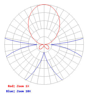 | ||||||||||||||||||||||||
| Azimuth | Ratio | Azimuth | Ratio | Azimuth | Ratio | Azimuth | Ratio | ||||||||||||||||||
| 0 | 1.000 | 10 | 0.970 | 20 | 0.880 | 30 | 0.760 | ||||||||||||||||||
| 40 | 0.620 | 50 | 0.460 | 60 | 0.330 | 70 | 0.200 | ||||||||||||||||||
| 80 | 0.110 | 90 | 0.020 | 100 | 0.060 | 110 | 0.110 | ||||||||||||||||||
| 120 | 0.140 | 130 | 0.160 | 140 | 0.150 | 150 | 0.110 | ||||||||||||||||||
| 160 | 0.070 | 170 | 0.040 | 180 | 0.020 | 190 | 0.040 | ||||||||||||||||||
| 200 | 0.070 | 210 | 0.110 | 220 | 0.150 | 230 | 0.160 | ||||||||||||||||||
| 240 | 0.140 | 250 | 0.110 | 260 | 0.060 | 270 | 0.020 | ||||||||||||||||||
| 280 | 0.110 | 290 | 0.200 | 300 | 0.330 | 310 | 0.460 | ||||||||||||||||||
| 320 | 0.620 | 330 | 0.760 | 340 | 0.880 | 350 | 0.970 | ||||||||||||||||||
Structure Registration Number 1033353 Structure Type: Registered To: VB-S1 Assets, LLC Structure Address: Casper Mountain Near Casper, WY County Name: Natrona County ASR Issued: 07/21/2020 Date Built: 01/01/1981 Site Elevation: 2445.1 m (8022 ft.) Structure Height: 121.9 m (400 ft.) Height Overall: 122.8 m (403 ft.) Overall Height AMSL: 2567.9 m (8425 ft.) FAA Determination: 08/06/2004 FAA Study #: 2004-ANM-58-OE Paint & Light FAA Chapters: 1, 3, 12, 21 Continue As Is OM&L = PAINT/RED LIGHTS 42-44-37.0 N 106-18-26.0 W (NAD 83) 42-44-37.1 N 106-18-23.9 W (Converted to NAD 27) |
4370 Peachtree Road, Ne Atlanta, GA 30319 Phone: 404-504-9828 Limited Liability Company | Title: Assistant Secretary Date: 09/27/2021 Application Certifier Gray Television Licensee, Llc 4370 Peachtree Road, Ne Atlanta, GA 30319 Applicant David Burke Raycom Media Licensee, Llc 201 Monroe Street Montgomery, AL 36104 Senior Vice President and CTO Joseph M. Davis, P.E. Chesapeake Rf Consultants, Llc 207 Old Dominion Road Yorktown, VA 23692 Consulting Engineer Mark Hildebrand Gray Television Licensee, Llc 141 Progress Circle Mills, WY 82644 Chief Engineer Joan Stewart Wiley Rein Llp 1776 K Street, Nw Washington, DC 20006 | |||||||||||||||||||||||
| |||||||||||||||||||||||||