
FCCInfo.com
A Service of Cavell, Mertz & Associates, Inc.
(855) FCC-INFO
|
|
K22OI-D from 07/02/2010 |
|
|
||||||||||||||||
|
|
Status: License Application Accepted: 10/14/2021 License Expires: 04/01/2022 File Number: -0000163791 FCC Website Links: LMS Facility Details This Application Other K22OI-D Applications Including Superseded Applications Mailing Address Correspondence for K22OI-D Correspondence related to application -0000163791 Service Contour - Open Street Map or USGS Map (51 dBu) Service Contour - KML / Google Earth (51 dBu) Rabbit Ears Info Search for K22OI-D Site Location: 39-25-23.0 N 107-22-33.0 W (NAD 83) Site Location: 39-25-23.1 N 107-22-30.8 W (Converted to NAD 27) ERP: 0.64 kW Polarization: Horizontally polarized R/C AGL: 29 m (95 ft.) R/C AMSL: 3247.7 m (10655 ft.) Emission Mask: Full Service Site Elevation: 3218.7 m. (10560 ft.) Height Overall*: 35.1 m (115 ft.) (* As Filed In This Application, may differ from ASR Data, Below.) Directional Antenna - Antenna Make/Model: Scala PR450U Antenna ID: 65078 Polarization: Horizontally polarized
| ||||||||||||||||||
| Antenna Data for Antenna Id: 65078 K22OI-D LD File: -0000163791 Scala - PR450U Service: LD Standard Pattern: Y Pattern and Field Values Include a 120° Clockwise Rotation | 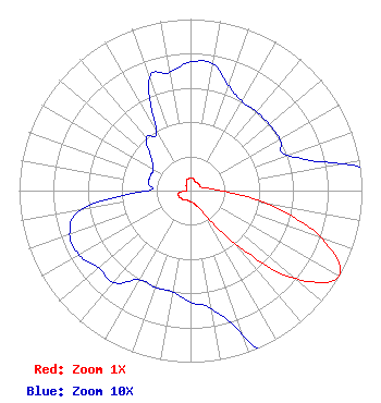 | ||||||||||||||||||
| Azimuth | Ratio | Azimuth | Ratio | Azimuth | Ratio | Azimuth | Ratio | ||||||||||||
| 0 | 0.075 | 10 | 0.075 | 20 | 0.065 | 30 | 0.060 | ||||||||||||
| 40 | 0.060 | 50 | 0.060 | 60 | 0.060 | 70 | 0.060 | ||||||||||||
| 80 | 0.090 | 90 | 0.180 | 100 | 0.460 | 110 | 0.815 | ||||||||||||
| 120 | 1.000 | 130 | 0.800 | 140 | 0.400 | 150 | 0.150 | ||||||||||||
| 160 | 0.090 | 170 | 0.070 | 180 | 0.065 | 190 | 0.060 | ||||||||||||
| 200 | 0.060 | 210 | 0.060 | 220 | 0.070 | 230 | 0.070 | ||||||||||||
| 240 | 0.075 | 250 | 0.075 | 260 | 0.065 | 270 | 0.025 | ||||||||||||
| 280 | 0.025 | 290 | 0.025 | 300 | 0.025 | 310 | 0.030 | ||||||||||||
| 320 | 0.040 | 330 | 0.040 | 340 | 0.070 | 350 | 0.070 | ||||||||||||
Structure Registration Number 1264553 Structure Type: TOWER Registered To: Pitkin County Translator Department Structure Address: Sunlight Peak Carbondale, CO County Name: Garfield County ASR Issued: 12/30/2014 Date Built: 01/31/2008 Site Elevation: 3218.7 m (10560 ft.) Structure Height: 35.1 m (115 ft.) Height Overall: 35.1 m (115 ft.) Overall Height AMSL: 3253.8 m (10675 ft.) FAA Determination: 07/18/2008 FAA Study #: 2008-anm-2245-oe Paint & Light FAA Chapters: NONE PRIOR STUDY 2005-ANM-1318-OE 39-25-23.0 N 107-22-33.0 W (NAD 83) 39-25-23.1 N 107-22-30.8 W (Converted to NAD 27) |
321 Southside Dr. Basalt, CO 81621 Phone: 970-429-6114 Government Entity | Title: Telecommunications Engineer Date: 10/14/2021 Application Certifier PITKIN COUNTY TRANSLATOR DEPARTMENT Pitkin County Translator Department 321 Southside Dr. Basalt, CO 81621 Applicant Jim McDonald B. W. St. Clair 117 East Eleventh St. Loveland, CO 80537 Engineering Consultant | |||||||||||||||||