
FCCInfo.com
A Service of Cavell, Mertz & Associates, Inc.
(855) FCC-INFO
|
|
|
RF spectrum relinquished in the spectrum auction Virtual Channel 49 |  |
|
||||||||||||||||||||||||
|
|
WLYH is a channel sharing guest of WHTM-TV, Harrisburg, Pennsylvania Repacking Information: Channel 30 was relinquished in the spectrum auction Status: License Application Accepted: 10/27/2021 License Expires: 08/01/2023 File Number: -0000164931 FCC Website Links: LMS Facility Details This Application Other WLYH Applications Including Superseded Applications Mailing Address Correspondence for WLYH Correspondence related to application -0000164931 Service Contour - Open Street Map or USGS Map (36 dBu) Service Contour - KML / Google Earth (36 dBu) Public Inspection Files History Cards for WLYH Rabbit Ears Info Search for WLYH Site Location: 40-18-57.8 N 76-57-01.0 W (NAD 83) Site Location: 40-18-57.5 N 76-57-02.1 W (Converted to NAD 27) ERP: 28.1 kW Polarization: Horizontally polarized HAAT: 311.1 m (1021 ft.) Electrical Beam Tilt: 0.5 degrees R/C AGL: 140.2 m (460 ft.) R/C AMSL: 469.4 m (1540 ft.) Site Elevation: 329.2 m. (1080 ft.) Height Overall*: 187 m (614 ft.) (* As Filed In This Application, may differ from ASR Data, Below.) Directional Antenna - Antenna Make/Model: DIELECTRIC THV-6A10-R S190 Antenna ID: 46002 Polarization: Horizontally polarized
| |||||||||||||||||||||||||||
| Antenna Data for Antenna Id: 46002 WLYH DT File: -0000164931 DIELECTRIC - THV-6A10-R S190 Service: DT Standard Pattern: Y Pattern and Field Values Include a 180° Clockwise Rotation | 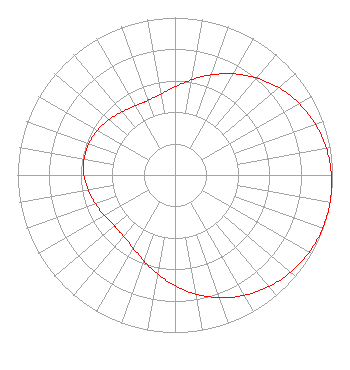 | |||||||||||||||||||||||||||
| Azimuth | Ratio | Azimuth | Ratio | Azimuth | Ratio | Azimuth | Ratio | |||||||||||||||||||||
| 0 | 0.560 | 10 | 0.614 | 20 | 0.677 | 30 | 0.742 | |||||||||||||||||||||
| 40 | 0.805 | 50 | 0.862 | 60 | 0.910 | 70 | 0.948 | |||||||||||||||||||||
| 80 | 0.975 | 90 | 0.993 | 100 | 1.000 | 102 | 1.000 | |||||||||||||||||||||
| 110 | 0.997 | 120 | 0.983 | 130 | 0.960 | 140 | 0.926 | |||||||||||||||||||||
| 150 | 0.882 | 160 | 0.829 | 170 | 0.768 | 180 | 0.703 | |||||||||||||||||||||
| 190 | 0.638 | 200 | 0.580 | 210 | 0.534 | 220 | 0.508 | |||||||||||||||||||||
| 228 | 0.503 | 230 | 0.503 | 240 | 0.516 | 250 | 0.537 | |||||||||||||||||||||
| 260 | 0.560 | 270 | 0.578 | 280 | 0.586 | 282 | 0.586 | |||||||||||||||||||||
| 290 | 0.582 | 300 | 0.568 | 310 | 0.547 | 320 | 0.524 | |||||||||||||||||||||
| 330 | 0.507 | 336 | 0.503 | 340 | 0.504 | 350 | 0.522 | |||||||||||||||||||||
Structure Registration Number 1033740 Structure Type: LTOWER Registered To: Nexstar Media Inc. Structure Address: Tower Road On Blue Mountain Summerdale, PA County Name: Cumberland County ASR Issued: 05/28/2021 Date Built: 03/01/1996 Site Elevation: 329.2 m (1080 ft.) Structure Height: 167.7 m (550 ft.) Height Overall: 187 m (614 ft.) Overall Height AMSL: 516.2 m (1694 ft.) FAA Determination: 02/27/2015 FAA Study #: 2014-AEA-7355-OE FAA Circular #: 70/7460-1J Paint & Light FAA Chapters: 3, 4, 5, 13 PRIOR STUDY 1997-AEA-1689-OE 40-18-57.8 N 76-57-01.0 W (NAD 83) 40-18-57.5 N 76-57-02.1 W (Converted to NAD 27) |
813 N. Fenwick Street Allentown, PA 18109 Phone: 610-351-8259 Not-for-Profit | Application Certifier Nrj Tv Rl License Co., Llc 722 S. Denton Tap Road Suite 130 Coppell, TX 75019 Applicant Ari Meltzer Wiley Rein Llp 1776 K Street Nw Washington, DC 20006 | ||||||||||||||||||||||||||