
FCCInfo.com
A Service of Cavell, Mertz & Associates, Inc.
(855) FCC-INFO
|
|
|
Post-repack Channel 16 Virtual Channel 28 |
|
||||||||||||||||
|
|
Repacking Information: Pre-Repack Channel: 28 Post-Repack Channel: 16 Post-Repack ERP: 113 kW Phase: 4 Completion Deadline: 8/2/2019 Upstream/Downstream Dependencies Other Linked Stations Find nearby TV Facilities Status: License Application Accepted: 11/03/2021 License Expires: 10/01/2028 File Number: -0000166002 FCC Website Links: LMS Facility Details This Application Other WCPB Applications Including Superseded Applications Mailing Address Correspondence for WCPB Correspondence related to application -0000166002 Service Contour - Open Street Map or USGS Map (41 dBu) Service Contour - KML / Google Earth (41 dBu) Public Inspection Files History Cards for WCPB Rabbit Ears Info Search for WCPB Site Location: 38-23-09.0 N 75-35-31.0 W (NAD 83) Site Location: 38-23-08.6 N 75-35-32.3 W (Converted to NAD 27) ERP: 320 kW Polarization: Elliptically polarized HAAT: 154 m (505 ft.) Electrical Beam Tilt: 0.50 degrees R/C AGL: 157.5 m (517 ft.) R/C AMSL: 165.7 m (544 ft.) Site Elevation: 8.2 m. (27 ft.) Height Overall*: 167.9 m (551 ft.) (* As Filed In This Application, may differ from ASR Data, Below.) Directional Antenna - Antenna Make/Model: R.F. Systems SAA29-O4A-J200-ET5R-16 Antenna ID: 1008884 Polarization: Elliptically polarized | ||||||||||||||||||
| Antenna Data for Antenna Id: 1008884 WCPB DT File: -0000166002 R.F. Systems - SAA29-O4A-J200-ET5R-16 Service: DT Standard Pattern: N | 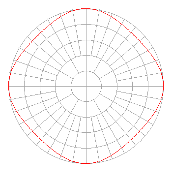 | ||||||||||||||||||
| Azimuth | Ratio | Azimuth | Ratio | Azimuth | Ratio | Azimuth | Ratio | ||||||||||||
| 0 | 1.000 | 10 | 0.986 | 20 | 0.953 | 30 | 0.921 | ||||||||||||
| 40 | 0.904 | 50 | 0.904 | 60 | 0.921 | 70 | 0.953 | ||||||||||||
| 80 | 0.986 | 90 | 1.000 | 100 | 0.986 | 110 | 0.953 | ||||||||||||
| 120 | 0.921 | 130 | 0.904 | 140 | 0.904 | 150 | 0.921 | ||||||||||||
| 160 | 0.953 | 170 | 0.986 | 180 | 1.000 | 190 | 0.986 | ||||||||||||
| 200 | 0.953 | 210 | 0.921 | 220 | 0.904 | 230 | 0.904 | ||||||||||||
| 240 | 0.921 | 250 | 0.953 | 260 | 0.986 | 270 | 1.000 | ||||||||||||
| 280 | 0.986 | 290 | 0.953 | 300 | 0.921 | 310 | 0.904 | ||||||||||||
| 320 | 0.904 | 330 | 0.921 | 340 | 0.953 | 350 | 0.986 | ||||||||||||
Structure Registration Number 1036645 Structure Type: TOWER Registered To: Maryland Public Broadcasting Commission Structure Address: 310 Deers Head Blvd Salisbury, MD County Name: Wicomico County ASR Issued: 06/05/2019 Date Built: 03/24/1997 Site Elevation: 8.2 m (27 ft.) Structure Height: 147.2 m (483 ft.) Height Overall: 167.9 m (551 ft.) Overall Height AMSL: 176.1 m (578 ft.) FAA Determination: 02/13/1968 FAA Study #: DCA-OE-67-171 Paint & Light FAA Chapters: 1, 3, 4, 13, 21 RED LIGHTS/PAINT 38-23-09.0 N 75-35-31.0 W (NAD 83) 38-23-08.6 N 75-35-32.3 W (Converted to NAD 27) |
11767 Owings Mills Boulevard Owings Mills, MD 21117 Phone: 410-356-5600 Government Entity | Title: Chief Technology Officer Date: 11/03/2021 Application Certifier Maryland Public Broadcasting Commission 11767 Owings Mills Boulevard Owings Mills, MD 21117 Applicant Joseph L Snelson, Jr Meintel, Sgrignoli And Wallace 1282 Smallwood Drive Suite 372 Waldorf, MD 20603 Melodie A. Virtue Foster Garvey Pc 1000 Potomac Street N.w. Suite 200 Washington, DC 20007 Travys Montague Maryland Public Television 11767 Owings Mills Blvd. Owings Mills, MD 21117 Chief Engineer Transmission and Distribution | |||||||||||||||||