
FCCInfo.com
A Service of Cavell, Mertz & Associates, Inc.
(855) FCC-INFO
|
|
|
|
|
|||||||||||||||||||||
|
|
Status: License Application Accepted: 11/12/2021 License Expires: 10/01/2029 File Number: -0000168187 FCC Website Links: LMS Facility Details This Application Other W27DG-D Applications Including Superseded Applications Mailing Address Correspondence for W27DG-D Correspondence related to application -0000168187 Service Contour - Open Street Map or USGS Map (51 dBu) Service Contour - KML / Google Earth (51 dBu) Rabbit Ears Info Search for W27DG-D Site Location: 40-53-55.0 N 81-12-36.0 W (NAD 83) Site Location: 40-53-54.8 N 81-12-36.6 W (Converted to NAD 27) ERP: 10.3 kW Polarization: Horizontally polarized R/C AGL: 88 m (289 ft.) R/C AMSL: 470 m (1542 ft.) Emission Mask: Full Service Site Elevation: 382 m. (1253 ft.) Height Overall*: 91.7 m (301 ft.) (* As Filed In This Application, may differ from ASR Data, Below.) Directional Antenna - Antenna Make/Model: SIRA UTV01 x 2 Antenna ID: 1008919 Polarization: Horizontally polarized
| |||||||||||||||||||||||
| Antenna Data for Antenna Id: 1008919 W27DG-D LD File: -0000168187 SIRA - UTV01 x 2 Service: LD Standard Pattern: N | 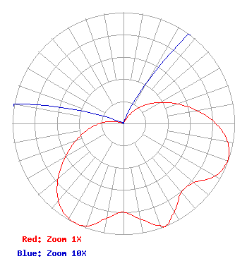 | |||||||||||||||||||||||
| Azimuth | Ratio | Azimuth | Ratio | Azimuth | Ratio | Azimuth | Ratio | |||||||||||||||||
| 0 | 0.001 | 10 | 0.001 | 20 | 0.005 | 30 | 0.043 | |||||||||||||||||
| 40 | 0.143 | 50 | 0.259 | 60 | 0.375 | 70 | 0.515 | |||||||||||||||||
| 80 | 0.669 | 90 | 0.830 | 100 | 0.951 | 110 | 0.995 | |||||||||||||||||
| 120 | 0.949 | 130 | 0.829 | 140 | 0.810 | 150 | 0.915 | |||||||||||||||||
| 158 | 1.000 | 160 | 0.978 | 170 | 0.873 | 180 | 0.799 | |||||||||||||||||
| 190 | 0.866 | 200 | 0.981 | 210 | 0.987 | 220 | 0.911 | |||||||||||||||||
| 230 | 0.769 | 240 | 0.605 | 250 | 0.457 | 260 | 0.325 | |||||||||||||||||
| 270 | 0.213 | 280 | 0.100 | 290 | 0.019 | 300 | 0.001 | |||||||||||||||||
| 310 | 0.001 | 320 | 0.001 | 330 | 0.001 | 340 | 0.001 | |||||||||||||||||
| 350 | 0.001 | |||||||||||||||||||||||
Structure Registration Number 1050165 Structure Type: TOWER Registered To: IMAGE VIDEO TELEPRODUCTIONS, INC. Structure Address: 1 Mi At Azimuth 68 Deg. Harrisburg, OH County Name: Stark County ASR Issued: 03/23/2009 Date Built: 06/24/1997 Site Elevation: 382 m (1253 ft.) Structure Height: 91.7 m (301 ft.) Height Overall: 91.7 m (301 ft.) Overall Height AMSL: 473.7 m (1554 ft.) FAA Determination: 01/14/1997 FAA Study #: 96-AGL-4261-OE FAA Circular #: 70/7460-1J Paint & Light FAA Chapters: 4, 6, 13 40-53-55.0 N 81-12-36.0 W (NAD 83) 40-53-54.8 N 81-12-36.6 W (Converted to NAD 27) |
38955 Hills Tech Dr. Farmington Hills, MI 48331 Phone: 248-536-0776 Limited Liability Company | Title: President Date: 11/12/2021 Application Certifier IMAGE VIDEO TELEPRODUCTIONS, INC. Image Video Teleproductions, Inc. 6755 Freedom Ave., N.w. North Canton, OH 44720 Applicant Darryl DeLawder Delawder Communications, Inc. Ashburn, VA 20146 Broadcast Consulting Engineer KATHLEEN VICTORY Fletcher, Heald & Hildreth, P.l.c. 1300 N. 17th St. 11th Floor Arlington, VA 22209 FCC COUNSEL | ||||||||||||||||||||||