
FCCInfo.com
A Service of Cavell, Mertz & Associates, Inc.
(855) FCC-INFO
|
|
KMLF-LD from 03/27/2012 |
|
|
||||||||||||||||
|
|
Status: Construction Permit Application Accepted: 02/17/2022 KMLF-LD CP Expires: 02/22/2025 File Number: -0000185001 FCC Website Links: LMS Facility Details This Application Other KMLF-LD Applications Including Superseded Applications Mailing Address Correspondence for KMLF-LD Correspondence related to application -0000185001 Service Contour - Open Street Map or USGS Map (51 dBu) Service Contour - KML / Google Earth (51 dBu) Rabbit Ears Info Search for KMLF-LD Site Location: 40-48-57.0 N 98-46-19.0 W (NAD 83) Site Location: 40-48-56.9 N 98-46-17.7 W (Converted to NAD 27) ERP: 15 kW Polarization: Elliptically polarized Electrical Beam Tilt: 0.75 degrees R/C AGL: 172.2 m (565 ft.) R/C AMSL: 796.1 m (2612 ft.) Emission Mask: Full Service Site Elevation: 623.9 m. (2047 ft.) Height Overall*: 214.3 m (703 ft.) (* As Filed In This Application, may differ from ASR Data, Below.) Directional Antenna - Antenna Make/Model: ATC ATC-BCE314CW-V4-21 Antenna ID: 1009306 Polarization: Elliptically polarized | ||||||||||||||||||
| Antenna Data for Antenna Id: 1009306 KMLF-LD LD File: -0000185001 ATC - ATC-BCE314CW-V4-21 Service: LD Standard Pattern: N Pattern and Field Values Include a 145° Clockwise Rotation | 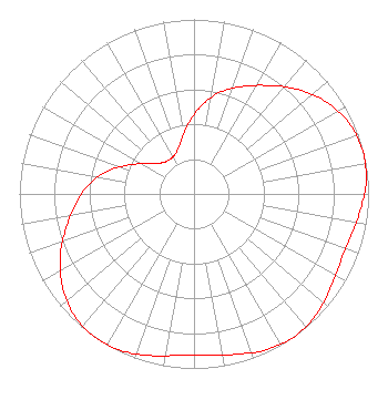 | ||||||||||||||||||
| Azimuth | Ratio | Azimuth | Ratio | Azimuth | Ratio | Azimuth | Ratio | ||||||||||||
| 5 | 0.510 | 15 | 0.605 | 25 | 0.680 | 35 | 0.758 | ||||||||||||
| 45 | 0.845 | 55 | 0.922 | 65 | 0.975 | 75 | 0.997 | ||||||||||||
| 85 | 0.990 | 95 | 0.959 | 105 | 0.929 | 115 | 0.925 | ||||||||||||
| 125 | 0.951 | 135 | 0.985 | 145 | 1.000 | 155 | 0.985 | ||||||||||||
| 165 | 0.951 | 175 | 0.925 | 185 | 0.929 | 195 | 0.959 | ||||||||||||
| 205 | 0.990 | 215 | 0.997 | 225 | 0.975 | 235 | 0.922 | ||||||||||||
| 245 | 0.845 | 255 | 0.758 | 265 | 0.680 | 275 | 0.605 | ||||||||||||
| 285 | 0.510 | 295 | 0.397 | 305 | 0.302 | 315 | 0.253 | ||||||||||||
| 325 | 0.241 | 335 | 0.253 | 345 | 0.302 | 355 | 0.397 | ||||||||||||
Structure Registration Number 1026974 Structure Type: TOWER Registered To: PLATTE RIVER RADIO INC DBA = KKPR FM RADIO Structure Address: .1 Mi E Of 145th & Sioux Rds Gibbon, NE County Name: Buffalo County ASR Issued: 11/12/1997 Date Built: 01/01/1986 Site Elevation: 623.9 m (2047 ft.) Structure Height: 213.4 m (700 ft.) Height Overall: 214.3 m (703 ft.) Overall Height AMSL: 838.2 m (2750 ft.) FAA Determination: 11/06/1997 FAA Study #: 97-ACE-1324-OE FAA Circular #: 70/7460-1J Paint & Light FAA Chapters: 3, 4, 5, 13 40-48-57.0 N 98-46-19.0 W (NAD 83) 40-48-56.9 N 98-46-17.7 W (Converted to NAD 27) |
214 N. 7th Street Suite 1 Norfolk, NE 68701 Phone: 402-371-0100 Limited Liability Company | Title: Managing Member Date: 02/17/2022 Application Certifier Flood Communications Tri-cities, L.l.c. 214 N. 7th Street Suite 1 Norfolk, NE 68701 Applicant Clarence M. Beverage Communications Technologies, Inc. 23 Binsted Drive Medford, NJ 08055 Broadcast Engineering Consultant Matthew H. McCormick, Esq Fletcher, Heald & Hildreth, P.l.c. 1300 N. 17th St. 11th Floor Arlington, VA 22209 Legal Counsel | |||||||||||||||||