
FCCInfo.com
A Service of Cavell, Mertz & Associates, Inc.
(855) FCC-INFO
|
|
K20OH-D from 02/25/2010 |
|
|
||||||||||||||||
|
|
Status: Construction Permit Application Accepted: 11/16/2021 K20OH-D CP Expires: 11/17/2024 File Number: -0000168880 FCC Website Links: LMS Facility Details This Application Other K20OH-D Applications Including Superseded Applications Mailing Address Correspondence for K20OH-D Correspondence related to application -0000168880 Service Contour - Open Street Map or USGS Map (51 dBu) Service Contour - KML / Google Earth (51 dBu) Rabbit Ears Info Search for K20OH-D Site Location: 34-06-06.7 N 96-52-48.3 W (NAD 83) Site Location: 34-06-06.4 N 96-52-47.3 W (Converted to NAD 27) ERP: 15 kW Polarization: Elliptically polarized Electrical Beam Tilt: 1 degree R/C AGL: 59.7 m (196 ft.) R/C AMSL: 326 m (1070 ft.) Emission Mask: Full Service Site Elevation: 266.3 m. (874 ft.) Height Overall*: 103.6 m (340 ft.) (* As Filed In This Application, may differ from ASR Data, Below.) Directional Antenna - Antenna Make/Model: Kathrein 75010325 Array Antenna ID: 1004794 Polarization: Elliptically polarized | ||||||||||||||||||
| Antenna Data for Antenna Id: 1004794 K20OH-D LD File: -0000168880 Kathrein - 75010325 Array Service: LD Standard Pattern: Y Pattern and Field Values Include a 300° Clockwise Rotation | 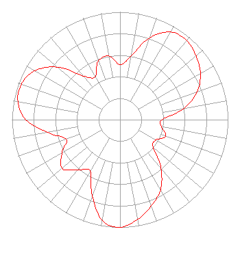 | ||||||||||||||||||
| Azimuth | Ratio | Azimuth | Ratio | Azimuth | Ratio | Azimuth | Ratio | ||||||||||||
| 0 | 0.510 | 10 | 0.600 | 20 | 0.810 | 30 | 0.940 | ||||||||||||
| 40 | 0.960 | 50 | 0.920 | 60 | 0.860 | 70 | 0.760 | ||||||||||||
| 80 | 0.600 | 90 | 0.390 | 100 | 0.390 | 110 | 0.450 | ||||||||||||
| 120 | 0.380 | 130 | 0.400 | 140 | 0.590 | 150 | 0.750 | ||||||||||||
| 160 | 0.850 | 170 | 0.940 | 180 | 1.000 | 190 | 0.950 | ||||||||||||
| 200 | 0.750 | 210 | 0.550 | 220 | 0.610 | 230 | 0.700 | ||||||||||||
| 240 | 0.620 | 250 | 0.530 | 260 | 0.680 | 270 | 0.870 | ||||||||||||
| 280 | 0.960 | 290 | 0.970 | 300 | 0.910 | 310 | 0.760 | ||||||||||||
| 320 | 0.530 | 330 | 0.460 | 340 | 0.580 | 350 | 0.600 | ||||||||||||
Structure Registration Number 1288856 Structure Type: GTOWER Registered To: American Towers LLC Structure Address: E Of Tyler, Ne Of Simpson Rd And Hwy 70 Tyler, OK County Name: Marshall County ASR Issued: 10/02/2017 Date Built: 10/18/2013 Site Elevation: 266.3 m (874 ft.) Structure Height: 97.5 m (320 ft.) Height Overall: 103.6 m (340 ft.) Overall Height AMSL: 369.9 m (1214 ft.) FAA Determination: 08/05/2013 FAA Study #: 2013-ASW-3393-OE FAA Circular #: 70/7460-1K Paint & Light FAA Chapters: 4, 8, 12 PRIOR STUDY 2013-ASW-3360-OE 34-06-06.7 N 96-52-48.3 W (NAD 83) 34-06-06.4 N 96-52-47.3 W (Converted to NAD 27) |
Hurst, TX 76054 Phone: 214-770-7770 Corporation | Title: Ceo Date: 11/16/2021 Application Certifier EDGE SPECTRUM, INC. Edge Spectrum, Inc. Hurst, TX 76054 Applicant Susan Hansen B. W. St. Clair 2305 Vida Shaw Rd. New Iberia, LA 70563 Consultant Randy Weiss Edge Spectrum, Inc. Hurst, TX 76054 CEO Caleb Weiss Ark Multicasting, Inc. Cedar Hill, TX 75106 President | |||||||||||||||||