
FCCInfo.com
A Service of Cavell, Mertz & Associates, Inc.
(855) FCC-INFO
|
|
K23PA-D from 06/02/2010 |
|
|
||||||||||||||||
|
|
Status: Construction Permit Application Accepted: 11/23/2021 K23PA-D CP Expires: 11/24/2024 File Number: -0000170865 FCC Website Links: LMS Facility Details This Application Other K23PA-D Applications Including Superseded Applications Mailing Address Correspondence for K23PA-D Correspondence related to application -0000170865 Service Contour - Open Street Map or USGS Map (51 dBu) Service Contour - KML / Google Earth (51 dBu) Rabbit Ears Info Search for K23PA-D Site Location: 42-12-17.9 N 121-41-16.2 W (NAD 83) Site Location: 42-12-18.4 N 121-41-12.2 W (Converted to NAD 27) ERP: 15 kW Polarization: Elliptically polarized R/C AGL: 35.2 m (115 ft.) R/C AMSL: 1429 m (4688 ft.) Emission Mask: Stringent Site Elevation: 1393.8 m. (4573 ft.) Height Overall*: 63.1 m (207 ft.) (* As Filed In This Application, may differ from ASR Data, Below.) Directional Antenna - Antenna Make/Model: DIELECTRIC DLP-8B Antenna ID: 100585 Polarization: Elliptically polarized | ||||||||||||||||||
| Antenna Data for Antenna Id: 100585 K23PA-D LD File: -0000170865 DIELECTRIC - DLP-8B Service: LD Standard Pattern: Y Pattern and Field Values Include a 325° Clockwise Rotation | 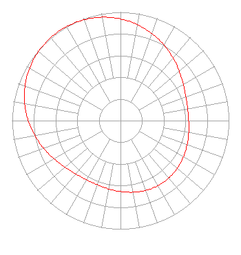 | ||||||||||||||||||
| Azimuth | Ratio | Azimuth | Ratio | Azimuth | Ratio | Azimuth | Ratio | ||||||||||||
| 5 | 0.918 | 15 | 0.875 | 25 | 0.828 | 35 | 0.778 | ||||||||||||
| 45 | 0.729 | 55 | 0.686 | 65 | 0.653 | 75 | 0.633 | ||||||||||||
| 85 | 0.627 | 95 | 0.632 | 105 | 0.646 | 115 | 0.662 | ||||||||||||
| 125 | 0.678 | 135 | 0.689 | 145 | 0.692 | 155 | 0.689 | ||||||||||||
| 165 | 0.678 | 175 | 0.662 | 185 | 0.646 | 195 | 0.632 | ||||||||||||
| 205 | 0.627 | 215 | 0.633 | 225 | 0.653 | 235 | 0.686 | ||||||||||||
| 245 | 0.729 | 255 | 0.778 | 265 | 0.828 | 275 | 0.875 | ||||||||||||
| 285 | 0.918 | 295 | 0.953 | 305 | 0.979 | 315 | 0.995 | ||||||||||||
| 325 | 1.000 | 335 | 0.995 | 345 | 0.979 | 355 | 0.953 | ||||||||||||
Structure Registration Number 1217658 Structure Type: LTOWER Registered To: American Towers LLC Structure Address: 2500 Vail Road (308321) Klamath Falls, OR County Name: Klamath County ASR Issued: 12/09/2022 Date Built: 06/09/2006 Site Elevation: 1393.9 m (4573 ft.) Structure Height: 60.4 m (198 ft.) Height Overall: 63.1 m (207 ft.) Overall Height AMSL: 1457 m (4780 ft.) FAA Determination: 12/02/2022 FAA Study #: 2022-ANM-7961-OE FAA Circular #: 70/7460-1K Paint & Light FAA Chapters: 4, 8, 12 OM&L to remain the same as prior study = A MED-DUAL SYSTEM 42-12-17.9 N 121-41-16.2 W (NAD 83) 42-12-18.4 N 121-41-12.2 W (Converted to NAD 27) |
Hurst, TX 76054 Phone: 214-770-7770 Corporation | Title: Ceo Date: 11/23/2021 Application Certifier EDGE SPECTRUM, INC. Edge Spectrum, Inc. Hurst, TX 76054 Applicant Susan Hansen B. W. St. Clair 2305 Vida Shaw Rd. New Iberia, LA 70563 Consultant Randy Weiss Edge Spectrum, Inc. Hurst, TX 76054 CEO Caleb Weiss Ark Multicasting, Inc. Cedar Hill, TX 75106 President | |||||||||||||||||