
FCCInfo.com
A Service of Cavell, Mertz & Associates, Inc.
(855) FCC-INFO
|
|
|
Post-repack Channel 22 Virtual Channel 49 |  |
|
||||||||||||||||
|
|
Repacking Information: Pre-Repack Channel: 49 Post-Repack Channel: 22 Post-Repack ERP: 52.3 kW Phase: 1 Completion Deadline: 11/30/2018 Find nearby TV Facilities Status: License Application Accepted: 11/24/2021 License Expires: 02/01/2022 File Number: -0000171221 FCC Website Links: LMS Facility Details This Application Other KRBK Applications Including Superseded Applications Mailing Address Correspondence for KRBK Correspondence related to application -0000171221 Service Contour - Open Street Map or USGS Map (41 dBu) Service Contour - KML / Google Earth (41 dBu) Public Inspection Files Rabbit Ears Info Search for KRBK Site Location: 37-13-09.4 N 92-56-57.4 W (NAD 83) Site Location: 37-13-09.2 N 92-56-56.8 W (Converted to NAD 27) ERP: 1000 kW Polarization: Elliptically polarized HAAT: 590 m (1936 ft.) Electrical Beam Tilt: 0.75 degrees R/C AGL: 551.9 m (1811 ft.) R/C AMSL: 1032 m (3386 ft.) Emission Mask: Simple Site Elevation: 480.1 m. (1575 ft.) Height Overall*: 608.4 m (1996 ft.) (* As Filed In This Application, may differ from ASR Data, Below.) Directional Antenna - Antenna Make/Model: DIELECTRIC TFU-28DSC/VP-R W Antenna ID: 1003741 Polarization: Elliptically polarized | |||||||||||||||||||
| Antenna Data for Antenna Id: 1003741 KRBK DT File: -0000171221 DIELECTRIC - TFU-28DSC/VP-R W Service: DT Standard Pattern: Y | 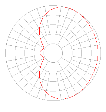 | |||||||||||||||||||
| Azimuth | Ratio | Azimuth | Ratio | Azimuth | Ratio | Azimuth | Ratio | |||||||||||||
| 0 | 0.926 | 10 | 0.979 | 20 | 0.999 | 22 | 1.000 | |||||||||||||
| 23 | 1.000 | 30 | 0.995 | 40 | 0.979 | 50 | 0.962 | |||||||||||||
| 60 | 0.950 | 70 | 0.944 | 80 | 0.943 | 90 | 0.943 | |||||||||||||
| 100 | 0.943 | 110 | 0.944 | 120 | 0.950 | 130 | 0.962 | |||||||||||||
| 140 | 0.979 | 150 | 0.995 | 157 | 1.000 | 158 | 1.000 | |||||||||||||
| 160 | 0.999 | 170 | 0.979 | 180 | 0.926 | 190 | 0.837 | |||||||||||||
| 200 | 0.713 | 210 | 0.568 | 220 | 0.417 | 230 | 0.289 | |||||||||||||
| 240 | 0.221 | 250 | 0.228 | 260 | 0.260 | 270 | 0.275 | |||||||||||||
| 280 | 0.260 | 290 | 0.228 | 300 | 0.221 | 310 | 0.289 | |||||||||||||
| 320 | 0.417 | 330 | 0.568 | 340 | 0.713 | 350 | 0.837 | |||||||||||||
Structure Registration Number 1028721 Structure Type: TOWER Registered To: American Towers LLC Structure Address: St Hwy F Nr (#30481) Marshfield, MO County Name: Webster County ASR Issued: 10/19/2018 Date Built: 01/01/1973 Site Elevation: 480.1 m (1575 ft.) Structure Height: 604.4 m (1983 ft.) Height Overall: 608.4 m (1996 ft.) Overall Height AMSL: 1088.5 m (3571 ft.) FAA Determination: 01/09/2007 FAA Study #: 2006-ACE-3009-OE Paint & Light FAA Chapters: 1, 3, 10.2, 19.2, 21 Continue As Is OM&L = PAINT/RED LIGHTS 37-13-09.4 N 92-56-57.4 W (NAD 83) 37-13-09.2 N 92-56-56.8 W (Converted to NAD 27) |
545 E. John Carpenter Freeway Suite 700 Irving, TX 75062 Phone: 972-373-8000 Corporation | Title: General Counsel Date: 11/24/2021 Application Certifier Nexstar Media Inc. 545 E. John Carpenter Freeway Suite 700 Irving, TX 75062 Applicant Elizabeth Ryder Nexstar Media Inc. 545 E. John Carpenter Freeway Suite 700 Irving, TX 75062 General Counsel | ||||||||||||||||||
