
FCCInfo.com
A Service of Cavell, Mertz & Associates, Inc.
(855) FCC-INFO
|
|
|
|
|
||||||||||||||||
|
|
Status: Construction Permit Application Accepted: 11/24/2021 K21LI-D CP Expires: 12/02/2024 File Number: -0000171177 FCC Website Links: LMS Facility Details This Application Other K21LI-D Applications Including Superseded Applications Mailing Address Correspondence for K21LI-D Correspondence related to application -0000171177 Service Contour - Open Street Map or USGS Map (51 dBu) Service Contour - KML / Google Earth (51 dBu) Rabbit Ears Info Search for K21LI-D Site Location: 43-32-35.8 N 111-53-11.3 W (NAD 83) Site Location: 43-32-36.1 N 111-53-08.4 W (Converted to NAD 27) ERP: 2.6 kW Polarization: Elliptically polarized R/C AGL: 42.2 m (138 ft.) R/C AMSL: 1734.4 m (5690 ft.) Emission Mask: Stringent Site Elevation: 1692.2 m. (5552 ft.) Height Overall*: 79.6 m (261 ft.) (* As Filed In This Application, may differ from ASR Data, Below.) Directional Antenna - Antenna Make/Model: Scala CL-1469 Antenna ID: 20778 Polarization: Elliptically polarized | ||||||||||||||||||
| Antenna Data for Antenna Id: 20778 K21LI-D LD File: -0000171177 Scala - CL-1469 Service: LD Standard Pattern: Y Pattern and Field Values Include a 265° Clockwise Rotation | 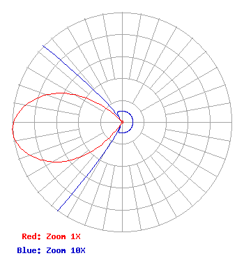 | ||||||||||||||||||
| Azimuth | Ratio | Azimuth | Ratio | Azimuth | Ratio | Azimuth | Ratio | ||||||||||||
| 5 | 0.010 | 15 | 0.010 | 25 | 0.010 | 35 | 0.010 | ||||||||||||
| 45 | 0.010 | 55 | 0.010 | 65 | 0.010 | 75 | 0.010 | ||||||||||||
| 85 | 0.010 | 95 | 0.010 | 105 | 0.010 | 115 | 0.010 | ||||||||||||
| 125 | 0.010 | 135 | 0.010 | 145 | 0.010 | 155 | 0.010 | ||||||||||||
| 165 | 0.010 | 175 | 0.010 | 185 | 0.010 | 195 | 0.010 | ||||||||||||
| 205 | 0.010 | 215 | 0.086 | 225 | 0.361 | 235 | 0.622 | ||||||||||||
| 245 | 0.812 | 255 | 0.947 | 265 | 1.000 | 275 | 0.947 | ||||||||||||
| 285 | 0.812 | 295 | 0.622 | 305 | 0.361 | 315 | 0.086 | ||||||||||||
| 325 | 0.010 | 335 | 0.010 | 345 | 0.010 | 355 | 0.010 | ||||||||||||
Structure Registration Number 1229651 Structure Type: TOWER Registered To: SpectraSite Communications, LLC. through American Towers, LLC. Structure Address: 5281 North Panarama Drive (303565) Idaho Falls, ID County Name: Bonneville County ASR Issued: 01/16/2013 Date Built: 09/17/2001 Site Elevation: 1692.2 m (5552 ft.) Structure Height: 76.2 m (250 ft.) Height Overall: 79.6 m (261 ft.) Overall Height AMSL: 1771.8 m (5813 ft.) FAA Determination: 05/17/2011 FAA Study #: 2011-ANM-1140-OE FAA Circular #: 70/7460-1K Paint & Light FAA Chapters: 4, 8, 12 PRIOR STUDY 2008-ANM-3426-OE 43-32-35.8 N 111-53-11.3 W (NAD 83) 43-32-36.1 N 111-53-08.4 W (Converted to NAD 27) |
Hurst, TX 76054 Phone: 214-770-7770 Corporation | Title: Ceo Date: 11/24/2021 Application Certifier EDGE SPECTRUM, INC. Edge Spectrum, Inc. Hurst, TX 76054 Applicant Susan Hansen B. W. St. Clair 2305 Vida Shaw Rd. New Iberia, LA 70563 Consultant Randy Weiss Edge Spectrum, Inc. Hurst, TX 76054 CEO Caleb Weiss Ark Multicasting, Inc. Cedar Hill, TX 75106 President | |||||||||||||||||