
FCCInfo.com
A Service of Cavell, Mertz & Associates, Inc.
(855) FCC-INFO
|
|
KSAW-LD from 04/26/1996 KSAW-LD from 11/30/1987 KSAW-LD from 01/28/1985 |
|
|
|||||||||||||||||||||||||
|
|
Status: License Application Accepted: 12/03/2021 License Expires: 10/03/2022 File Number: -0000176722 FCC Website Links: LMS Facility Details This Application Other KSAW-LD Applications Including Superseded Applications Mailing Address Correspondence for KSAW-LD Correspondence related to application -0000176722 Service Contour - Open Street Map or USGS Map (51 dBu) Service Contour - KML / Google Earth (51 dBu) Rabbit Ears Info Search for KSAW-LD Site Location: 42-43-45.9 N 114-24-56.5 W (NAD 83) Site Location: 42-43-46.2 N 114-24-53.4 W (Converted to NAD 27) ERP: 15 kW Polarization: Horizontally polarized R/C AGL: 33.5 m (110 ft.) R/C AMSL: 1341.5 m (4401 ft.) Emission Mask: Simple Site Elevation: 1308 m. (4291 ft.) Height Overall*: 55.5 m (182 ft.) (* As Filed In This Application, may differ from ASR Data, Below.) Directional Antenna - Antenna Make/Model: Jampro JUHD-5/3 (15) Antenna ID: 1008985 Polarization: Horizontally polarized | |||||||||||||||||||||||||||
| Antenna Data for Antenna Id: 1008985 KSAW-LD LD File: -0000176722 Jampro - JUHD-5/3 (15) Service: LD Standard Pattern: N Pattern and Field Values Include a 190° Clockwise Rotation | 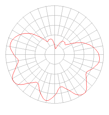 | |||||||||||||||||||||||||||
| Azimuth | Ratio | Azimuth | Ratio | Azimuth | Ratio | Azimuth | Ratio | |||||||||||||||||||||
| 0 | 0.191 | 10 | 0.118 | 20 | 0.191 | 30 | 0.310 | |||||||||||||||||||||
| 40 | 0.321 | 50 | 0.305 | 60 | 0.466 | 70 | 0.664 | |||||||||||||||||||||
| 80 | 0.810 | 90 | 0.902 | 100 | 0.917 | 110 | 0.832 | |||||||||||||||||||||
| 120 | 0.750 | 130 | 0.850 | 140 | 0.989 | 144 | 1.000 | |||||||||||||||||||||
| 150 | 0.951 | 160 | 0.760 | 170 | 0.678 | 180 | 0.843 | |||||||||||||||||||||
| 190 | 0.955 | 200 | 0.843 | 210 | 0.678 | 220 | 0.760 | |||||||||||||||||||||
| 230 | 0.951 | 236 | 1.000 | 240 | 0.989 | 250 | 0.850 | |||||||||||||||||||||
| 260 | 0.750 | 270 | 0.832 | 280 | 0.917 | 290 | 0.902 | |||||||||||||||||||||
| 300 | 0.810 | 310 | 0.664 | 320 | 0.466 | 330 | 0.305 | |||||||||||||||||||||
| 340 | 0.321 | 350 | 0.310 | |||||||||||||||||||||||||
Structure Registration Number 1236585 Structure Type: TOWER Registered To: State Board Of Education, State of Idaho Structure Address: Near 547 Flat Top Butte Road Jerome, ID County Name: Jerome County ASR Issued: 11/06/2002 Date Built: 04/18/2003 Site Elevation: 1308 m (4291 ft.) Structure Height: 36.6 m (120 ft.) Height Overall: 55.5 m (182 ft.) Overall Height AMSL: 1363.5 m (4473 ft.) FAA Determination: 09/13/2002 FAA Study #: 2002-ANM-1446-OE Paint & Light FAA Chapters: NONE Removed expiration date from determination. Scenario 1./jjs/case#635066 42-43-45.9 N 114-24-56.5 W (NAD 83) 42-43-46.2 N 114-24-53.4 W (Converted to NAD 27) |
312 Walnut Street 28th Floor Cincinnati, OH 45202 Phone: 513-977-3000 Limited Liability Company | Title: Vice President/engineering Date: 12/03/2021 Application Certifier SCRIPPS BROADCASTING HOLDINGS LLC Scripps Broadcasting Holdings Llc 312 Walnut Street 28th Floor Cincinnati, OH 45202 Applicant Daniel Kirkpatrick Baker & Hostetler Llp 1050 Connecticut Avenue Suite 1100 Washington, DC 20036 Benjamin Pidek, P.E Ben Pidek Consulting, Llc 7670 Coventry Dr. Temperance, MI 48182 Consulting Engineer | ||||||||||||||||||||||||||
| ||||||||||||||||||||||||||||