
FCCInfo.com
A Service of Cavell, Mertz & Associates, Inc.
(855) FCC-INFO
|
|
|
Virtual Channel 27 |  |
|
||||||||||||||||||||||||
|
|
WHTM-TV is a channel sharing host for WLYH, Red Lion, Pennsylvania Repacking Information: No changes Status: License Application Accepted: 12/07/2021 License Expires: 08/01/2023 File Number: -0000176940 FCC Website Links: LMS Facility Details This Application Other WHTM-TV Applications Including Superseded Applications Mailing Address Correspondence for WHTM-TV Correspondence related to application -0000176940 Service Contour - Open Street Map or USGS Map (36 dBu) Service Contour - KML / Google Earth (36 dBu) Public Inspection Files History Cards for WHTM-TV Rabbit Ears Info Search for WHTM-TV Site Location: 40-18-57.8 N 76-57-01.0 W (NAD 83) Site Location: 40-18-57.5 N 76-57-02.1 W (Converted to NAD 27) ERP: 28.1 kW Polarization: Horizontally polarized HAAT: 311.1 m (1021 ft.) Electrical Beam Tilt: 0.5 degrees R/C AGL: 140.2 m (460 ft.) R/C AMSL: 469.4 m (1540 ft.) Site Elevation: 329.2 m. (1080 ft.) Height Overall*: 187 m (614 ft.) (* As Filed In This Application, may differ from ASR Data, Below.) Directional Antenna - Antenna Make/Model: DIELECTRIC THV-6A10-R S190 Antenna ID: 46002 Polarization: Horizontally polarized | |||||||||||||||||||||||||||
| Antenna Data for Antenna Id: 46002 WHTM-TV DT File: -0000176940 DIELECTRIC - THV-6A10-R S190 Service: DT Standard Pattern: Y Pattern and Field Values Include a 180° Clockwise Rotation | 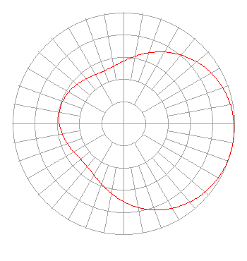 | |||||||||||||||||||||||||||
| Azimuth | Ratio | Azimuth | Ratio | Azimuth | Ratio | Azimuth | Ratio | |||||||||||||||||||||
| 0 | 0.560 | 10 | 0.614 | 20 | 0.677 | 30 | 0.742 | |||||||||||||||||||||
| 40 | 0.805 | 50 | 0.862 | 60 | 0.910 | 70 | 0.948 | |||||||||||||||||||||
| 80 | 0.975 | 90 | 0.993 | 100 | 1.000 | 102 | 1.000 | |||||||||||||||||||||
| 110 | 0.997 | 120 | 0.983 | 130 | 0.960 | 140 | 0.926 | |||||||||||||||||||||
| 150 | 0.882 | 160 | 0.829 | 170 | 0.768 | 180 | 0.703 | |||||||||||||||||||||
| 190 | 0.638 | 200 | 0.580 | 210 | 0.534 | 220 | 0.508 | |||||||||||||||||||||
| 228 | 0.503 | 230 | 0.503 | 240 | 0.516 | 250 | 0.537 | |||||||||||||||||||||
| 260 | 0.560 | 270 | 0.578 | 280 | 0.586 | 282 | 0.586 | |||||||||||||||||||||
| 290 | 0.582 | 300 | 0.568 | 310 | 0.547 | 320 | 0.524 | |||||||||||||||||||||
| 330 | 0.507 | 336 | 0.503 | 340 | 0.504 | 350 | 0.522 | |||||||||||||||||||||
Structure Registration Number 1033740 Structure Type: LTOWER Registered To: Nexstar Media Inc. Structure Address: Tower Road On Blue Mountain Summerdale, PA County Name: Cumberland County ASR Issued: 05/28/2021 Date Built: 03/01/1996 Site Elevation: 329.2 m (1080 ft.) Structure Height: 167.7 m (550 ft.) Height Overall: 187 m (614 ft.) Overall Height AMSL: 516.2 m (1694 ft.) FAA Determination: 02/27/2015 FAA Study #: 2014-AEA-7355-OE FAA Circular #: 70/7460-1J Paint & Light FAA Chapters: 3, 4, 5, 13 PRIOR STUDY 1997-AEA-1689-OE 40-18-57.8 N 76-57-01.0 W (NAD 83) 40-18-57.5 N 76-57-02.1 W (Converted to NAD 27) |
545 E. John Carpenter Freeway Suite 700 Irving, TX 75062 Phone: 972-373-8800 Corporation | Title: General Counsel Date: 12/07/2021 Application Certifier Nexstar Media Inc. 545 E. John Carpenter Freeway Suite 700 Irving, TX 75062 Applicant Greg Best Greg Best Consulting, Inc. 16100 Outlook Avenue Stilwell, KS 66085 Consulting Engineer Elizabeth Ryder Nexstar Media Inc. 545 E. John Carpenter Freeway Suite 700 Irving, TX 75062 General Counsel | ||||||||||||||||||||||||||
|
| |||||||||||||||||||||||||||
