
FCCInfo.com
A Service of Cavell, Mertz & Associates, Inc.
(855) FCC-INFO
|
|
W24EZ-D from 02/03/2022 W24EZ-D from 12/29/2015 W24EZ-D from 06/12/2015 W24EZ-D from 12/08/1987 |
|
|
||||||||||||||||
|
|
Status: License Application Accepted: 12/23/2021 License Expires: 04/03/2023 File Number: -0000177861 FCC Website Links: LMS Facility Details This Application Other WETN-LD Applications Including Superseded Applications Mailing Address Correspondence for WETN-LD Correspondence related to application -0000177861 Service Contour - Open Street Map or USGS Map (51 dBu) Service Contour - KML / Google Earth (51 dBu) Rabbit Ears Info Search for WETN-LD Site Location: 41-17-28.3 N 72-58-04.3 W (NAD 83) Site Location: 41-17-28.0 N 72-58-05.9 W (Converted to NAD 27) ERP: 6 kW Polarization: Horizontally polarized R/C AGL: 52.3 m (172 ft.) R/C AMSL: 98 m (322 ft.) Emission Mask: Full Service Site Elevation: 45.7 m. (150 ft.) Height Overall*: 60.7 m (199 ft.) (* As Filed In This Application, may differ from ASR Data, Below.) Directional Antenna - Antenna Make/Model: Propagation System Inc PSILP-OI Antenna ID: 1009075 Polarization: Horizontally polarized | ||||||||||||||||||
| Antenna Data for Antenna Id: 1009075 WETN-LD LD File: -0000177861 Propagation System Inc - PSILP-OI Service: LD Standard Pattern: N | 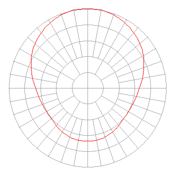 | ||||||||||||||||||
| Azimuth | Ratio | Azimuth | Ratio | Azimuth | Ratio | Azimuth | Ratio | ||||||||||||
| 0 | 1.000 | 10 | 1.000 | 20 | 0.980 | 30 | 0.950 | ||||||||||||
| 40 | 0.910 | 50 | 0.870 | 60 | 0.820 | 70 | 0.760 | ||||||||||||
| 80 | 0.710 | 90 | 0.660 | 100 | 0.630 | 110 | 0.610 | ||||||||||||
| 120 | 0.600 | 130 | 0.600 | 140 | 0.620 | 150 | 0.640 | ||||||||||||
| 160 | 0.660 | 170 | 0.670 | 180 | 0.670 | 190 | 0.670 | ||||||||||||
| 200 | 0.660 | 210 | 0.640 | 220 | 0.620 | 230 | 0.600 | ||||||||||||
| 240 | 0.600 | 250 | 0.610 | 260 | 0.630 | 270 | 0.660 | ||||||||||||
| 280 | 0.710 | 290 | 0.760 | 300 | 0.820 | 310 | 0.870 | ||||||||||||
| 320 | 0.910 | 330 | 0.950 | 340 | 0.980 | 350 | 1.000 | ||||||||||||
Structure Registration Number 1200863 Structure Type: TOWER Registered To: PAGING ASSOICATES, INC. Structure Address: 24 Rockdale Road West Haven, CT County Name: New Haven County ASR Issued: 08/03/1999 Date Built: 08/03/1999 Site Elevation: 45.7 m (150 ft.) Structure Height: 54.9 m (180 ft.) Height Overall: 60.7 m (199 ft.) Overall Height AMSL: 106.4 m (349 ft.) FAA Determination: 04/30/1985 FAA Study #: 85-ANE-095-OE Paint & Light FAA Chapters: NONE 41-17-28.3 N 72-58-04.3 W (NAD 83) 41-17-28.0 N 72-58-05.9 W (Converted to NAD 27) |
24 Rockdale Road West Haven, CT 06516 Phone: 203-640-2050 Corporation | Title: President Date: 12/23/2021 Application Certifier RADIO COMMUNICATIONS CORPORATION Radio Communications Corporation 24 Rockdale Road West Haven, CT 06516 Applicant Timothy E. Welch Hill & Welch 1116 Heartfields Dr Silver Spring, MD 20904 Attorney | |||||||||||||||||
| |||||||||||||||||||