
FCCInfo.com
A Service of Cavell, Mertz & Associates, Inc.
(855) FCC-INFO
|
|
W21EO-D from 03/27/2012 |
|
|
|||||||||||||||||
|
|
Status: License Application Accepted: 12/14/2021 License Expires: 04/03/2023 File Number: -0000177257 FCC Website Links: LMS Facility Details This Application Other W21EO-D Applications Including Superseded Applications Mailing Address Correspondence for W21EO-D Correspondence related to application -0000177257 Service Contour - Open Street Map or USGS Map (51 dBu) Service Contour - KML / Google Earth (51 dBu) Rabbit Ears Info Search for W21EO-D Site Location: 44-42-11.6 N 69-04-45.1 W (NAD 83) Site Location: 44-42-11.3 N 69-04-46.9 W (Converted to NAD 27) ERP: 0.2 kW Polarization: Horizontally polarized R/C AGL: 11 m (36 ft.) R/C AMSL: 373.2 m (1224 ft.) Emission Mask: Stringent Site Elevation: 362.2 m. (1188 ft.) Height Overall*: 155 m (509 ft.) (* As Filed In This Application, may differ from ASR Data, Below.) Directional Antenna - Antenna Make/Model: ELTI ELTI UHF Panel Antenna ID: 1008435 Polarization: Horizontally polarized
| |||||||||||||||||||
| Antenna Data for Antenna Id: 1008435 W21EO-D LD File: -0000177257 ELTI - ELTI UHF Panel Service: LD Standard Pattern: Y Pattern and Field Values Include a 60° Clockwise Rotation | 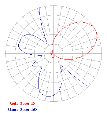 | |||||||||||||||||||
| Azimuth | Ratio | Azimuth | Ratio | Azimuth | Ratio | Azimuth | Ratio | |||||||||||||
| 0 | 0.263 | 10 | 0.389 | 20 | 0.537 | 30 | 0.700 | |||||||||||||
| 40 | 0.851 | 50 | 0.955 | 60 | 1.000 | 70 | 0.955 | |||||||||||||
| 80 | 0.851 | 90 | 0.700 | 100 | 0.531 | 110 | 0.367 | |||||||||||||
| 120 | 0.232 | 130 | 0.132 | 140 | 0.052 | 150 | 0.028 | |||||||||||||
| 160 | 0.053 | 170 | 0.075 | 180 | 0.087 | 190 | 0.090 | |||||||||||||
| 200 | 0.084 | 210 | 0.062 | 220 | 0.038 | 230 | 0.044 | |||||||||||||
| 240 | 0.050 | 250 | 0.033 | 260 | 0.025 | 270 | 0.056 | |||||||||||||
| 280 | 0.073 | 290 | 0.074 | 300 | 0.072 | 310 | 0.060 | |||||||||||||
| 320 | 0.033 | 330 | 0.029 | 340 | 0.082 | 350 | 0.158 | |||||||||||||
Structure Registration Number 1225781 Structure Type: TOWER Registered To: Gray Media Group, Inc. Structure Address: On Top Of Peaked Mountain, Off Route #9 Dixmont, ME County Name: Penobscot County ASR Issued: 09/09/2020 Date Built: 07/30/2001 Site Elevation: 362.2 m (1188 ft.) Structure Height: 135 m (443 ft.) Height Overall: 155 m (509 ft.) Overall Height AMSL: 517.2 m (1697 ft.) FAA Determination: 05/16/2001 FAA Study #: 01-ANE-0219-OE FAA Circular #: 70/7460-1K Paint & Light FAA Chapters: 3, 4, 5, 12 PRIOR STUDY 00-ANE-0325-OE SUPPLEMENTAL NOTICE STATES STRUCTURE REACHED GREATEST HEIGHT ON 07/15/2001 44-42-11.6 N 69-04-45.1 W (NAD 83) 44-42-11.3 N 69-04-46.9 W (Converted to NAD 27) |
14 Tuxedo Drive Beaufort, SC 29907 Phone: 717-226-3535 Limited Liability Company | Title: Manager Date: 12/14/2021 Application Certifier LANDOVER 2 LLC Landover 2 Llc 380 Lexington Ave. 17th Floor New York, NY 10168 Applicant Darryl DeLawder Delawder Communications, Inc. P.o. Box 1095 Ashburn, VA 20146 President Aaron Shainis Shainis & Peltzman, Chartered 1850 M Street, Nw Suite 240 Washington, DC 20036 Legal Counsel | ||||||||||||||||||