
FCCInfo.com
A Service of Cavell, Mertz & Associates, Inc.
(855) FCC-INFO
|
|
W24EI-D from 05/29/2012 |
|
|
||||||||||||||||
|
|
Status: Construction Permit Application Accepted: 12/14/2021 W24EI-D CP Expires: 12/17/2024 File Number: -0000177282 FCC Website Links: LMS Facility Details This Application Other W24EI-D Applications Including Superseded Applications Mailing Address Correspondence for W24EI-D Correspondence related to application -0000177282 Service Contour - Open Street Map or USGS Map (43 dBu) Service Contour - KML / Google Earth (43 dBu) Rabbit Ears Info Search for W24EI-D Site Location: 18-10-20.7 N 66-35-30.1 W (NAD 83) Site Location: 18-10-27.8 N 66-35-31.5 W (Converted to NAD 27) ERP: 3 kW Polarization: Horizontally polarized Electrical Beam Tilt: 1.5 degrees R/C AGL: 30 m (98 ft.) R/C AMSL: 1355 m (4446 ft.) Emission Mask: Full Service Site Elevation: 1325 m. (4347 ft.) Height Overall*: 68.6 m (225 ft.) (* As Filed In This Application, may differ from ASR Data, Below.) Directional Antenna - Antenna Make/Model: Kathrein CL-46 Antenna ID: 1003126 Polarization: Horizontally polarized | ||||||||||||||||||
| Antenna Data for Antenna Id: 1003126 W24EI-D LD File: -0000177282 Kathrein - CL-46 Service: LD Standard Pattern: Y Pattern and Field Values Include a 260° Clockwise Rotation | 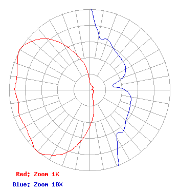 | ||||||||||||||||||
| Azimuth | Ratio | Azimuth | Ratio | Azimuth | Ratio | Azimuth | Ratio | ||||||||||||
| 0 | 0.117 | 10 | 0.068 | 20 | 0.066 | 30 | 0.059 | ||||||||||||
| 40 | 0.056 | 50 | 0.054 | 60 | 0.052 | 70 | 0.044 | ||||||||||||
| 80 | 0.029 | 90 | 0.044 | 100 | 0.052 | 110 | 0.054 | ||||||||||||
| 120 | 0.056 | 130 | 0.059 | 140 | 0.066 | 150 | 0.068 | ||||||||||||
| 160 | 0.117 | 170 | 0.298 | 180 | 0.459 | 190 | 0.649 | ||||||||||||
| 200 | 0.824 | 210 | 0.932 | 220 | 1.000 | 230 | 0.951 | ||||||||||||
| 240 | 0.917 | 250 | 0.927 | 260 | 0.898 | 270 | 0.927 | ||||||||||||
| 280 | 0.917 | 290 | 0.951 | 300 | 1.000 | 310 | 0.932 | ||||||||||||
| 320 | 0.824 | 330 | 0.649 | 340 | 0.459 | 350 | 0.298 | ||||||||||||
Structure Registration Number 1017057 Structure Type: TOWER Registered To: CCATT PR LLC Structure Address: Road 143 Jayuya, PR County Name: Jayuya Municipio ASR Issued: 01/30/2019 Date Built: 04/13/2009 Site Elevation: 1325 m (4347 ft.) Structure Height: 61.3 m (201 ft.) Height Overall: 68.6 m (225 ft.) Overall Height AMSL: 1393.6 m (4572 ft.) FAA Determination: 12/08/2009 FAA Study #: 2009-ASO-5376-OE FAA Circular #: 70/7460-1K Paint & Light FAA Chapters: 4, 6, 12 OM&L to remain the same as prior study = 24-HR MED-STROBES 18-10-20.7 N 66-35-30.1 W (NAD 83) 18-10-27.8 N 66-35-31.5 W (Converted to NAD 27) |
Po Box 4956 Pmb 2024 Caguas, PR 00726 Phone: 787-223-4562 OWNER | Title: Consulting Engineer Date: 12/14/2021 Application Certifier RAMON A HERNANDEZ Ramon A Hernandez Po Box 4956 Pmb 2024 Caguas, PR 00726 Applicant Alejandro Luciano, PE Alejandro Luciano Pe San Juan, PR 00919 CONSULTING ENGINEER LEE J PELTZMAN Shainis & Peltzman Chartered 1850 M Street Nw Suite #240 Washington, DC 20036 | |||||||||||||||||