
FCCInfo.com
A Service of Cavell, Mertz & Associates, Inc.
(855) FCC-INFO
|
|
W27EP-D from 11/14/2014 W27EP-D from 06/02/2010 |
|
|
||||||||||||||||
|
|
Status: License Application Accepted: 12/15/2021 License Expires: 02/01/2029 File Number: -0000177339 FCC Website Links: LMS Facility Details This Application Other W27EP-D Applications Including Superseded Applications Mailing Address Correspondence for W27EP-D Correspondence related to application -0000177339 Service Contour - Open Street Map or USGS Map (51 dBu) Service Contour - KML / Google Earth (51 dBu) Rabbit Ears Info Search for W27EP-D Site Location: 30-30-48.3 N 86-27-53.6 W (NAD 83) Site Location: 30-30-47.6 N 86-27-53.8 W (Converted to NAD 27) ERP: 15 kW Polarization: Horizontally polarized Electrical Beam Tilt: 0.25 degrees R/C AGL: 70 m (230 ft.) R/C AMSL: 83.7 m (275 ft.) Emission Mask: Full Service Site Elevation: 13.7 m. (45 ft.) Height Overall*: 85.6 m (281 ft.) (* As Filed In This Application, may differ from ASR Data, Below.) Directional Antenna - Antenna Make/Model: Propagation System Inc PSILP-8BC-27 Antenna ID: 1004959 Polarization: Horizontally polarized | ||||||||||||||||||
| Antenna Data for Antenna Id: 1004959 W27EP-D LD File: -0000177339 Propagation System Inc - PSILP-8BC-27 Service: LD Standard Pattern: N Pattern and Field Values Include a 70° Clockwise Rotation | 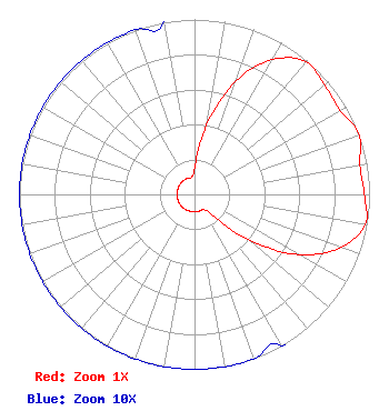 | ||||||||||||||||||
| Azimuth | Ratio | Azimuth | Ratio | Azimuth | Ratio | Azimuth | Ratio | ||||||||||||
| 0 | 0.150 | 10 | 0.400 | 20 | 0.690 | 30 | 0.890 | ||||||||||||
| 40 | 0.990 | 50 | 0.970 | 60 | 0.960 | 70 | 1.000 | ||||||||||||
| 80 | 0.960 | 90 | 0.970 | 100 | 0.990 | 110 | 0.890 | ||||||||||||
| 120 | 0.690 | 130 | 0.400 | 140 | 0.150 | 150 | 0.100 | ||||||||||||
| 160 | 0.100 | 170 | 0.100 | 180 | 0.100 | 190 | 0.100 | ||||||||||||
| 200 | 0.100 | 210 | 0.100 | 220 | 0.100 | 230 | 0.100 | ||||||||||||
| 240 | 0.100 | 250 | 0.100 | 260 | 0.100 | 270 | 0.100 | ||||||||||||
| 280 | 0.100 | 290 | 0.100 | 300 | 0.100 | 310 | 0.100 | ||||||||||||
| 320 | 0.100 | 330 | 0.100 | 340 | 0.100 | 350 | 0.100 | ||||||||||||
Structure Registration Number 1039189 Structure Type: TOWER Registered To: Pinnacle Towers LLC Structure Address: 203 Bailey Drive Niceville, FL County Name: Okaloosa County ASR Issued: 05/06/2016 Date Built: 01/01/1995 Site Elevation: 13.7 m (45 ft.) Structure Height: 80.2 m (263 ft.) Height Overall: 85.6 m (281 ft.) Overall Height AMSL: 99.3 m (326 ft.) FAA Determination: 10/09/2001 FAA Study #: 01-ASO-6759-OE FAA Circular #: 70/7460-1H Paint & Light FAA Chapters: 4, 5, 6, 8, 13 PRIOR STUDY 94-ASO-1893-OE 30-30-48.3 N 86-27-53.6 W (NAD 83) 30-30-47.6 N 86-27-53.8 W (Converted to NAD 27) |
Hurst, TX 76054 Phone: 214-770-7770 Corporation | Title: Ceo Date: 12/15/2021 Application Certifier EDGE SPECTRUM, INC. Edge Spectrum, Inc. Hurst, TX 76054 Applicant Susan Hansen B. W. St. Clair 2305 Vida Shaw Rd. New Iberia, LA 70563 Consultant Randy Weiss Edge Spectrum, Inc. Hurst, TX 76054 CEO Caleb Weiss Ark Multicasting, Inc. Cedar Hill, TX 75106 President | |||||||||||||||||