
FCCInfo.com
A Service of Cavell, Mertz & Associates, Inc.
(855) FCC-INFO
|
|
K30MC-D from 02/22/2011 |
|
|
||||||||||||||||
|
|
Status: Construction Permit Application Accepted: 12/17/2021 K30MC-D CP Expires: 12/20/2024 File Number: -0000177425 FCC Website Links: LMS Facility Details This Application Other K30MC-D Applications Including Superseded Applications Mailing Address Correspondence for K30MC-D Correspondence related to application -0000177425 Service Contour - Open Street Map or USGS Map (51 dBu) Service Contour - KML / Google Earth (51 dBu) Rabbit Ears Info Search for K30MC-D Site Location: 46-30-55.8 N 116-56-46.4 W (NAD 83) Site Location: 46-30-56.2 N 116-56-42.8 W (Converted to NAD 27) ERP: 15 kW Polarization: Elliptically polarized R/C AGL: 66.2 m (217 ft.) R/C AMSL: 930 m (3051 ft.) Emission Mask: Simple Site Elevation: 863.8 m. (2834 ft.) Height Overall*: 96 m (315 ft.) (* As Filed In This Application, may differ from ASR Data, Below.) Directional Antenna - Antenna Make/Model: DIELECTRIC DLP-8B Antenna ID: 100585 Polarization: Elliptically polarized | ||||||||||||||||||
| Antenna Data for Antenna Id: 100585 K30MC-D LD File: -0000177425 DIELECTRIC - DLP-8B Service: LD Standard Pattern: Y | 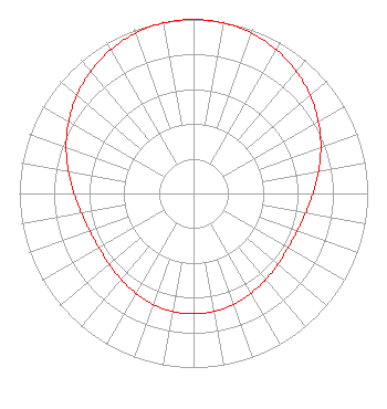 | ||||||||||||||||||
| Azimuth | Ratio | Azimuth | Ratio | Azimuth | Ratio | Azimuth | Ratio | ||||||||||||
| 0 | 1.000 | 10 | 0.995 | 20 | 0.979 | 30 | 0.953 | ||||||||||||
| 40 | 0.918 | 50 | 0.875 | 60 | 0.828 | 70 | 0.778 | ||||||||||||
| 80 | 0.729 | 90 | 0.686 | 100 | 0.653 | 110 | 0.633 | ||||||||||||
| 120 | 0.627 | 130 | 0.632 | 140 | 0.646 | 150 | 0.662 | ||||||||||||
| 160 | 0.678 | 170 | 0.689 | 180 | 0.692 | 190 | 0.689 | ||||||||||||
| 200 | 0.678 | 210 | 0.662 | 220 | 0.646 | 230 | 0.632 | ||||||||||||
| 240 | 0.627 | 250 | 0.633 | 260 | 0.653 | 270 | 0.686 | ||||||||||||
| 280 | 0.729 | 290 | 0.778 | 300 | 0.828 | 310 | 0.875 | ||||||||||||
| 320 | 0.918 | 330 | 0.953 | 340 | 0.979 | 350 | 0.995 | ||||||||||||
Structure Registration Number 1227037 Structure Type: TOWER Registered To: American Towers LLC Structure Address: 17268 Evans Rd. (genesee/dowdy #41977--pnw) Genesse, ID County Name: Nez Perce County ASR Issued: 01/15/2013 Date Built: 08/30/2001 Site Elevation: 863.8 m (2834 ft.) Structure Height: 92.3 m (303 ft.) Height Overall: 96 m (315 ft.) Overall Height AMSL: 959.8 m (3149 ft.) FAA Determination: 05/05/2003 FAA Study #: 2003-ANM-964-OE FAA Circular #: 70/7460-1K Paint & Light FAA Chapters: 4, 8, 12 Removed expiration date from determination. Scenario 1./jjs/case#635066 46-30-55.8 N 116-56-46.4 W (NAD 83) 46-30-56.2 N 116-56-42.8 W (Converted to NAD 27) |
Hurst, TX 76054 Phone: 214-770-7770 Corporation | Title: Ceo Date: 12/17/2021 Application Certifier EDGE SPECTRUM, INC. Edge Spectrum, Inc. Hurst, TX 76054 Applicant Josh Weiss Ark Multicasting, Inc. Cedar Hill, TX 75106 CEO Susan Hansen B. W. St. Clair 2305 Vida Shaw Rd. New Iberia, LA 70563 Consultant Randy Weiss Edge Spectrum, Inc. Hurst, TX 76054 CEO Caleb Weiss Ark Multicasting, Inc. Cedar Hill, TX 75106 President | |||||||||||||||||