
FCCInfo.com
A Service of Cavell, Mertz & Associates, Inc.
(855) FCC-INFO
|
|
KTFO-CD from 03/01/2007 KTFO-CD from 09/01/2005 KTFO-CD from 03/01/2002 KTFO-CD from 05/04/2001 KTFO-CD from 03/28/1988 |
Virtual Channel 31 |
|
|||||||||||||||||
|
|
Repacking Information: No changes Status: License Application Accepted: 03/21/2022 License Expires: 08/01/2022 File Number: -0000186956 FCC Website Links: LMS Facility Details This Application Other KTFO-CD Applications Including Superseded Applications Mailing Address Correspondence for KTFO-CD Correspondence related to application -0000186956 Service Contour - Open Street Map or USGS Map (51 dBu) Service Contour - KML / Google Earth (51 dBu) Public Inspection Files Rabbit Ears Info Search for KTFO-CD Site Location: 30-19-34.0 N 97-47-59.0 W (NAD 83) Site Location: 30-19-33.3 N 97-47-58.0 W (Converted to NAD 27) ERP: 15 kW Polarization: Elliptically polarized Electrical Beam Tilt: 1.5 degrees R/C AGL: 292.6 m (960 ft.) R/C AMSL: 551.6 m (1810 ft.) Emission Mask: Stringent Site Elevation: 259 m. (850 ft.) Height Overall*: 365 m (1198 ft.) (* As Filed In This Application, may differ from ASR Data, Below.) Directional Antenna - Antenna Make/Model: Electronics Research Inc. AL12W-36-PLE Antenna ID: 1009387 Polarization: Elliptically polarized | |||||||||||||||||||
| Antenna Data for Antenna Id: 1009387 KTFO-CD DC File: -0000186956 Electronics Research Inc. - AL12W-36-PLE Service: DC Standard Pattern: N Pattern and Field Values Include a 90° Clockwise Rotation | 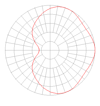 | |||||||||||||||||||
| Azimuth | Ratio | Azimuth | Ratio | Azimuth | Ratio | Azimuth | Ratio | |||||||||||||
| 0 | 0.922 | 10 | 0.975 | 20 | 0.997 | 30 | 0.990 | |||||||||||||
| 40 | 0.959 | 50 | 0.929 | 60 | 0.925 | 70 | 0.951 | |||||||||||||
| 80 | 0.985 | 90 | 1.000 | 100 | 0.985 | 110 | 0.951 | |||||||||||||
| 120 | 0.925 | 130 | 0.929 | 140 | 0.959 | 150 | 0.990 | |||||||||||||
| 160 | 0.997 | 170 | 0.975 | 180 | 0.922 | 190 | 0.845 | |||||||||||||
| 200 | 0.758 | 210 | 0.680 | 220 | 0.605 | 230 | 0.510 | |||||||||||||
| 240 | 0.397 | 250 | 0.302 | 260 | 0.253 | 270 | 0.241 | |||||||||||||
| 280 | 0.253 | 290 | 0.302 | 300 | 0.397 | 310 | 0.510 | |||||||||||||
| 320 | 0.605 | 330 | 0.680 | 340 | 0.758 | 350 | 0.845 | |||||||||||||
Structure Registration Number 1050398 Structure Type: TOWER Registered To: Nexstar Media Inc. Structure Address: 5416 Buckman Mountain Austin, TX County Name: Travis County ASR Issued: 10/17/2022 Date Built: 09/22/1965 Site Elevation: 259 m (850 ft.) Structure Height: 329 m (1079 ft.) Height Overall: 365 m (1198 ft.) Overall Height AMSL: 624 m (2047 ft.) FAA Determination: 06/05/1964 FAA Study #: 64-SW-3 Paint & Light FAA Chapters: 1, 3, 8, 17, 21 RED LIGHTS/PAINT 30-19-34.0 N 97-47-59.0 W (NAD 83) 30-19-33.3 N 97-47-58.0 W (Converted to NAD 27) |
101 Constitution Avenue, Nw, Suite 800w Washington, DC 20001 Phone: 310-348-3600 Limited Partnership | Title: Svp, Assoc Gc Gov And Reg Aff Date: 03/21/2022 Application Certifier KAKW LICENSE PARTNERSHIP, L.P. Kakw License Partnership, L.p. 5999 Center Drive Los Angeles, CA 90045 Applicant Gregory Coburn Univision Communications Inc 101 Constitution Ave Nw Washington, DC 20001 MATTHEW S. DELNERO Covington & Burling Llp One Citycenter 850 Tenth Street Nw Washington, DC 20001 | ||||||||||||||||||
| ||||||||||||||||||||
