
FCCInfo.com
A Service of Cavell, Mertz & Associates, Inc.
(855) FCC-INFO
|
|
WJSJ-CD from 07/08/2009 WJSJ-CD from 07/09/2007 WJSJ-CD from 08/30/1996 WJSJ-CD from 10/26/1990 |
Post-repack Channel 28 |
|
||||||||||||||||
|
|
Repacking Information: Pre-Repack Channel: 51 Post-Repack Channel: 28 Post-Repack ERP: 0.93 kW Phase: 6 Completion Deadline: 10/18/2019 Find nearby TV Facilities Status: License Application Accepted: 12/29/2021 License Expires: 08/01/2029 File Number: -0000178129 FCC Website Links: LMS Facility Details This Application Other WJSJ-CD Applications Including Superseded Applications Mailing Address Correspondence for WJSJ-CD Correspondence related to application -0000178129 Service Contour - Open Street Map or USGS Map (51 dBu) Service Contour - KML / Google Earth (51 dBu) Public Inspection Files Rabbit Ears Info Search for WJSJ-CD Site Location: 40-17-29.2 N 86-01-37.9 W (NAD 83) Site Location: 40-17-29.1 N 86-01-37.9 W (Converted to NAD 27) ERP: 6 kW Polarization: Circularly polarized R/C AGL: 70.1 m (230 ft.) R/C AMSL: 334.7 m (1098 ft.) Emission Mask: Full Service Site Elevation: 264.6 m. (868 ft.) Height Overall*: 105.5 m (346 ft.) (* As Filed In This Application, may differ from ASR Data, Below.) Directional Antenna - Antenna Make/Model: ATC BPC CUSTOM Antenna ID: 1009091 Polarization: Circularly polarized | ||||||||||||||||||
| Antenna Data for Antenna Id: 1009091 WJSJ-CD DC File: -0000178129 ATC - BPC CUSTOM Service: DC Standard Pattern: N | 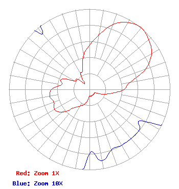 | ||||||||||||||||||
| Azimuth | Ratio | Azimuth | Ratio | Azimuth | Ratio | Azimuth | Ratio | ||||||||||||
| 0 | 0.550 | 10 | 0.690 | 20 | 0.860 | 30 | 0.960 | ||||||||||||
| 40 | 1.000 | 50 | 0.960 | 60 | 0.890 | 70 | 0.740 | ||||||||||||
| 80 | 0.510 | 90 | 0.430 | 100 | 0.280 | 110 | 0.170 | ||||||||||||
| 120 | 0.080 | 130 | 0.080 | 140 | 0.080 | 150 | 0.080 | ||||||||||||
| 160 | 0.080 | 170 | 0.090 | 180 | 0.080 | 190 | 0.140 | ||||||||||||
| 200 | 0.200 | 210 | 0.240 | 220 | 0.300 | 230 | 0.440 | ||||||||||||
| 240 | 0.500 | 250 | 0.470 | 260 | 0.500 | 270 | 0.470 | ||||||||||||
| 280 | 0.350 | 290 | 0.370 | 300 | 0.210 | 310 | 0.200 | ||||||||||||
| 320 | 0.090 | 330 | 0.220 | 340 | 0.250 | 350 | 0.429 | ||||||||||||
Structure Registration Number 1300875 Structure Type: GTOWER Registered To: Telecom Properties, LLC Structure Address: 400 W And 100 S Tipton, IN County Name: Tipton County ASR Issued: 11/28/2016 Date Built: 01/18/2017 Site Elevation: 264.6 m (868 ft.) Structure Height: 103.6 m (340 ft.) Height Overall: 105.5 m (346 ft.) Overall Height AMSL: 370.1 m (1214 ft.) FAA Determination: 08/29/2016 FAA Study #: 2016-AGL-11044-OE FAA Circular #: 70/7460-1L Paint & Light FAA Chapters: 4, 8, 12 Removed expiration date from determination. Scenario 1./jjs/case#635066 40-17-29.2 N 86-01-37.9 W (NAD 83) 40-17-29.1 N 86-01-37.9 W (Converted to NAD 27) |
500 Summer St. Suite 502 Stamford, CT 06901 Phone: 203-349-9000 Limited Liability Company | Title: President Date: 12/29/2021 Application Certifier 5gtv Llc 500 Summer St. Suite 502 Stamford, CT 06901 Applicant David D Oxenford Wilkinson Barker Knauer, Llp 1800 M Street, Nw Suite 800n Washington, DC 20036 Legal Counsel | |||||||||||||||||
| |||||||||||||||||||