
FCCInfo.com
A Service of Cavell, Mertz & Associates, Inc.
(855) FCC-INFO
|
|
KOCY-LD from 02/09/2012 KOCY-LD from 11/22/2011 KOCY-LD from 05/13/2005 KOCY-LD from 08/24/1987 |
Virtual Channel 48 |
|
||||||||||||||||
|
|
Status: License Application Accepted: 01/04/2022 License Expires: 06/01/2022 File Number: -0000178645 FCC Website Links: LMS Facility Details This Application Other KOCY-LD Applications Including Superseded Applications Mailing Address Correspondence for KOCY-LD Correspondence related to application -0000178645 Service Contour - Open Street Map or USGS Map (51 dBu) Service Contour - KML / Google Earth (51 dBu) Rabbit Ears Info Search for KOCY-LD Site Location: 35-24-54.4 N 97-30-33.1 W (NAD 83) Site Location: 35-24-54.2 N 97-30-32.0 W (Converted to NAD 27) ERP: 15 kW Polarization: Horizontally polarized Electrical Beam Tilt: 0.5 degrees R/C AGL: 170.7 m (560 ft.) R/C AMSL: 544 m (1785 ft.) Emission Mask: Simple Site Elevation: 373.3 m. (1225 ft.) Height Overall*: 189 m (620 ft.) (* As Filed In This Application, may differ from ASR Data, Below.) Directional Antenna - Antenna Make/Model: Kathrein SL-BB-16 Antenna ID: 1009119 Polarization: Horizontally polarized | ||||||||||||||||||
| Antenna Data for Antenna Id: 1009119 KOCY-LD LD File: -0000178645 Kathrein - SL-BB-16 Service: LD Standard Pattern: N | 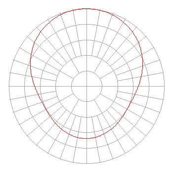 | ||||||||||||||||||
| Azimuth | Ratio | Azimuth | Ratio | Azimuth | Ratio | Azimuth | Ratio | ||||||||||||
| 0 | 1.000 | 10 | 0.994 | 20 | 0.978 | 30 | 0.951 | ||||||||||||
| 40 | 0.915 | 50 | 0.871 | 60 | 0.820 | 70 | 0.767 | ||||||||||||
| 80 | 0.715 | 90 | 0.668 | 100 | 0.631 | 110 | 0.609 | ||||||||||||
| 120 | 0.602 | 130 | 0.608 | 140 | 0.623 | 150 | 0.642 | ||||||||||||
| 160 | 0.656 | 170 | 0.672 | 180 | 0.676 | 190 | 0.672 | ||||||||||||
| 200 | 0.659 | 210 | 0.642 | 220 | 0.623 | 230 | 0.608 | ||||||||||||
| 240 | 0.602 | 250 | 0.609 | 260 | 0.631 | 270 | 0.668 | ||||||||||||
| 280 | 0.715 | 290 | 0.767 | 300 | 0.820 | 310 | 0.871 | ||||||||||||
| 320 | 0.915 | 330 | 0.951 | 340 | 0.978 | 350 | 0.994 | ||||||||||||
Structure Registration Number 1210193 Structure Type: GTOWER Registered To: Tyler Enterprises L.L.C. Structure Address: 5003 S. Shields Blvd. Oklahoma City, OK County Name: Oklahoma County ASR Issued: 06/05/2019 Date Built: 02/13/2015 Site Elevation: 373.3 m (1225 ft.) Structure Height: 182.9 m (600 ft.) Height Overall: 189 m (620 ft.) Overall Height AMSL: 562.3 m (1845 ft.) FAA Determination: 09/18/2014 FAA Study #: 2014-ASW-3975-OE FAA Circular #: 70/7460-1K Paint & Light FAA Chapters: 3, 4, 5, 12 FAA CHAPTERS 3,4,5,12; 70/7460-1K with bird deviation special condition. PRIOR STUDY NUMBER: 2006-ASW-5419-OE 35-24-54.4 N 97-30-33.1 W (NAD 83) 35-24-54.2 N 97-30-32.0 W (Converted to NAD 27) |
5101 S. Shields Blvd. Oklahoma City, OK 73129 Phone: 405-616-5500 Applicant | Title: Manager Date: 01/04/2022 Application Certifier TYLER MEDIA LLC Tyler Media Llc 5101 S. Shields Blvd. Oklahoma City, OK 73129 Applicant John Charles Trent, Esq Putbrese Hunsaker & Trent, P.c. 200 South Church Street Woodstock, VA 22664 Counsel Douglas L Vernier Doug Vernier, Telecommunications Consultants 1600 Picturesque Dr. Cedar Falls, IA 50613 Engineering Consultant | |||||||||||||||||