
FCCInfo.com
A Service of Cavell, Mertz & Associates, Inc.
(855) FCC-INFO
|
|
WRDP-LD from 01/30/2012 |
|
|
||||||||||||||||
|
|
Status: License Application Accepted: 01/05/2022 License Expires: 04/02/2029 File Number: -0000178766 FCC Website Links: LMS Facility Details This Application Other WRDP-LD Applications Including Superseded Applications Mailing Address Correspondence for WRDP-LD Correspondence related to application -0000178766 Service Contour - Open Street Map or USGS Map (51 dBu) Service Contour - KML / Google Earth (51 dBu) Rabbit Ears Info Search for WRDP-LD Site Location: 32-27-29.0 N 84-53-08.0 W (NAD 83) Site Location: 32-27-28.5 N 84-53-08.3 W (Converted to NAD 27) ERP: 0.2 kW Polarization: Horizontally polarized R/C AGL: 15.2 m (50 ft.) R/C AMSL: 132.5 m (435 ft.) Emission Mask: Simple Site Elevation: 117.3 m. (385 ft.) Height Overall*: 400.9 m (1315 ft.) (* As Filed In This Application, may differ from ASR Data, Below.) Directional Antenna - Antenna Make/Model: Scala CL-1469 Antenna ID: 20778 Polarization: Horizontally polarized | ||||||||||||||||||
| Antenna Data for Antenna Id: 20778 WRDP-LD LD File: -0000178766 Scala - CL-1469 Service: LD Standard Pattern: Y Pattern and Field Values Include a 300° Clockwise Rotation | 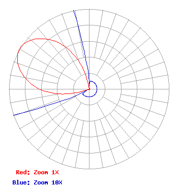 | ||||||||||||||||||
| Azimuth | Ratio | Azimuth | Ratio | Azimuth | Ratio | Azimuth | Ratio | ||||||||||||
| 0 | 0.010 | 10 | 0.010 | 20 | 0.010 | 30 | 0.010 | ||||||||||||
| 40 | 0.010 | 50 | 0.010 | 60 | 0.010 | 70 | 0.010 | ||||||||||||
| 80 | 0.010 | 90 | 0.010 | 100 | 0.010 | 110 | 0.010 | ||||||||||||
| 120 | 0.010 | 130 | 0.010 | 140 | 0.010 | 150 | 0.010 | ||||||||||||
| 160 | 0.010 | 170 | 0.010 | 180 | 0.010 | 190 | 0.010 | ||||||||||||
| 200 | 0.010 | 210 | 0.010 | 220 | 0.010 | 230 | 0.010 | ||||||||||||
| 240 | 0.010 | 250 | 0.086 | 260 | 0.361 | 270 | 0.622 | ||||||||||||
| 280 | 0.812 | 290 | 0.947 | 300 | 1.000 | 310 | 0.947 | ||||||||||||
| 320 | 0.812 | 330 | 0.622 | 340 | 0.361 | 350 | 0.086 | ||||||||||||
Structure Registration Number 1032658 Structure Type: TOWER Registered To: Gray Media Group, Inc. Structure Address: 6140 Buena Vista Road Columbus, GA County Name: Muscogee County ASR Issued: 12/28/2020 Date Built: 09/23/1982 Site Elevation: 117.3 m (385 ft.) Structure Height: 381.8 m (1253 ft.) Height Overall: 400.9 m (1315 ft.) Overall Height AMSL: 518.2 m (1700 ft.) FAA Determination: 08/01/1997 FAA Study #: 97-ASO-3017-OE FAA Circular #: 70/7460-1J Paint & Light FAA Chapters: 3, 4, 5, 13 32-27-29.0 N 84-53-08.0 W (NAD 83) 32-27-28.5 N 84-53-08.3 W (Converted to NAD 27) |
38955 Hills Tech Dr. Farmington Hills, MI 48331 Phone: 248-536-0776 Limited Liability Company | Title: Ceo Date: 01/05/2022 Application Certifier Innovative Media Technologies Inc. 5174 Mcginnis Ferry Road Suite 133 Alpharetta, GA 30005 Applicant Susan Hansen B. W. St. Clair 2305 Vida Shaw Rd. New Iberia, LA 70563 Consultant | |||||||||||||||||