
FCCInfo.com
A Service of Cavell, Mertz & Associates, Inc.
(855) FCC-INFO
|
|
K30RA-D from 10/02/2012 |
|
|
||||||||||||||||
|
|
Status: License Application Accepted: 01/05/2022 License Expires: 04/01/2030 File Number: -0000178831 FCC Website Links: LMS Facility Details This Application Other K30RA-D Applications Including Superseded Applications Mailing Address Correspondence for K30RA-D Correspondence related to application -0000178831 Service Contour - Open Street Map or USGS Map (51 dBu) Service Contour - KML / Google Earth (51 dBu) Rabbit Ears Info Search for K30RA-D Site Location: 43-55-02.1 N 92-26-20.7 W (NAD 83) Site Location: 43-55-02.2 N 92-26-20.1 W (Converted to NAD 27) ERP: 1.55 kW Polarization: Horizontally polarized R/C AGL: 9.1 m (30 ft.) R/C AMSL: 390.7 m (1282 ft.) Emission Mask: Simple Site Elevation: 381.6 m. (1252 ft.) Height Overall*: 59.1 m (194 ft.) (* As Filed In This Application, may differ from ASR Data, Below.) Directional Antenna - Antenna Make/Model: Kathrein 1x K723147 Antenna ID: 1008960 Polarization: Horizontally polarized | ||||||||||||||||||
| Antenna Data for Antenna Id: 1008960 K30RA-D LD File: -0000178831 Kathrein - 1x K723147 Service: LD Standard Pattern: Y | 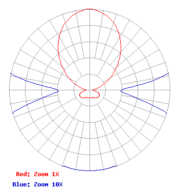 | ||||||||||||||||||
| Azimuth | Ratio | Azimuth | Ratio | Azimuth | Ratio | Azimuth | Ratio | ||||||||||||
| 0 | 1.000 | 10 | 0.960 | 20 | 0.880 | 30 | 0.750 | ||||||||||||
| 40 | 0.600 | 50 | 0.440 | 60 | 0.300 | 70 | 0.170 | ||||||||||||
| 80 | 0.090 | 90 | 0.040 | 100 | 0.060 | 110 | 0.120 | ||||||||||||
| 120 | 0.140 | 130 | 0.140 | 140 | 0.130 | 150 | 0.110 | ||||||||||||
| 160 | 0.100 | 170 | 0.100 | 180 | 0.100 | 190 | 0.100 | ||||||||||||
| 200 | 0.100 | 210 | 0.110 | 220 | 0.130 | 230 | 0.140 | ||||||||||||
| 240 | 0.140 | 250 | 0.120 | 260 | 0.060 | 270 | 0.040 | ||||||||||||
| 280 | 0.090 | 290 | 0.170 | 300 | 0.300 | 310 | 0.440 | ||||||||||||
| 320 | 0.600 | 330 | 0.750 | 340 | 0.880 | 350 | 0.960 | ||||||||||||
Structure Registration Number 1011357 Structure Type: GTOWER Registered To: Gray Media Group, Inc. Structure Address: County Rd. 20 Se, 0.46 Mi. N Of I-90 Overpass Simpson, MN County Name: Olmsted County ASR Issued: 08/03/2021 Date Built: 01/01/1960 Site Elevation: 381.6 m (1252 ft.) Structure Height: 54.9 m (180 ft.) Height Overall: 59.1 m (194 ft.) Overall Height AMSL: 440.7 m (1446 ft.) FAA Determination: 03/06/2015 FAA Study #: 2014-AGL-15723-OE Paint & Light FAA Chapters: 1, 3, 11, 21 Continue As Is OM&L = PAINT/RED LIGHTS 43-55-02.1 N 92-26-20.7 W (NAD 83) 43-55-02.2 N 92-26-20.1 W (Converted to NAD 27) |
4370 Peachtree Road, Ne Atlanta, GA 30319 Phone: 404-266-8333 Limited Liability Company | Title: Assistant Secretary Date: 01/05/2022 Application Certifier Gray Television Licensee, LLC Gray Television Licensee, Llc 4370 Peachtree Road, Ne Atlanta, GA 30319 Applicant Joseph M. Davis, P.E. Chesapeake Rf Consultants, Llc 207 Old Dominion Road Yorktown, VA 23692 Consulting Engineer Joan Stewart Wiley Rein Llp 1776 K Street, Nw Washington, DC 20006 | |||||||||||||||||