
FCCInfo.com
A Service of Cavell, Mertz & Associates, Inc.
(855) FCC-INFO
|
|
|
|
|
||||||||||||||||
|
|
Status: License Application Accepted: 01/06/2022 License Expires: 02/01/2023 File Number: -0000178883 FCC Website Links: LMS Facility Details This Application Other K13KU-D Applications Including Superseded Applications Mailing Address Correspondence for K13KU-D Correspondence related to application -0000178883 Service Contour - Open Street Map or USGS Map (48 dBu) Service Contour - KML / Google Earth (48 dBu) Rabbit Ears Info Search for K13KU-D Site Location: 63-47-14.1 N 145-51-47.8 W (NAD 83) Site Location: 63-47-15.5 N 145-51-39.5 W (Converted to NAD 27) ERP: 0.34 kW Polarization: Horizontally polarized R/C AGL: 7.6 m (25 ft.) R/C AMSL: 915 m (3002 ft.) Emission Mask: Simple Site Elevation: 907.4 m. (2977 ft.) Height Overall*: 71.9 m (236 ft.) (* As Filed In This Application, may differ from ASR Data, Below.) Directional Antenna - Antenna Make/Model: Scala CL-713 Antenna ID: 1009132 Polarization: Horizontally polarized
| ||||||||||||||||||
| Antenna Data for Antenna Id: 1009132 K13KU-D LD File: -0000178883 Scala - CL-713 Service: LD Standard Pattern: N Pattern and Field Values Include a 13° Clockwise Rotation | 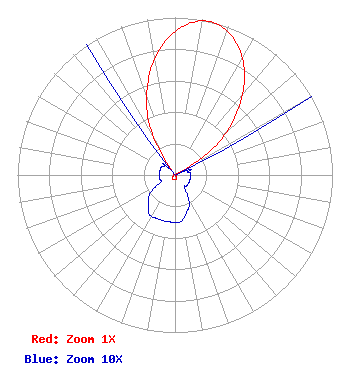 | ||||||||||||||||||
| Azimuth | Ratio | Azimuth | Ratio | Azimuth | Ratio | Azimuth | Ratio | ||||||||||||
| 3 | 0.945 | 13 | 1.000 | 23 | 0.945 | 33 | 0.805 | ||||||||||||
| 43 | 0.598 | 53 | 0.352 | 63 | 0.030 | 73 | 0.010 | ||||||||||||
| 83 | 0.010 | 93 | 0.010 | 103 | 0.010 | 113 | 0.010 | ||||||||||||
| 123 | 0.010 | 133 | 0.010 | 143 | 0.010 | 153 | 0.020 | ||||||||||||
| 163 | 0.025 | 173 | 0.030 | 183 | 0.030 | 193 | 0.030 | ||||||||||||
| 203 | 0.030 | 213 | 0.030 | 223 | 0.025 | 233 | 0.020 | ||||||||||||
| 243 | 0.010 | 253 | 0.010 | 263 | 0.010 | 273 | 0.010 | ||||||||||||
| 283 | 0.010 | 293 | 0.010 | 303 | 0.010 | 313 | 0.010 | ||||||||||||
| 323 | 0.030 | 333 | 0.352 | 343 | 0.598 | 353 | 0.805 | ||||||||||||
Structure Registration Number 1005547 Structure Type: LTOWER Registered To: Alascom Inc. Structure Address: Mp 249 Richardson Hwy Delta Junction, AK County Name: Southeast Fairbanks Census Area ASR Issued: 11/01/2022 Date Built: 11/05/1991 Site Elevation: 907.4 m (2977 ft.) Structure Height: 65.2 m (214 ft.) Height Overall: 71.9 m (236 ft.) Overall Height AMSL: 979.3 m (3213 ft.) FAA Determination: 02/24/2016 FAA Study #: 2016-AAL-129-OE Paint & Light FAA Chapters: A1, H, 3, 11, 21, 23 PRIOR STUDY 1999-AAL-219-OE 63-47-14.1 N 145-51-47.8 W (NAD 83) 63-47-15.5 N 145-51-39.5 W (Converted to NAD 27) |
8620 Cold Springs Road Raleigh, NC 27615 Phone: 919-414-9288 Limited Liability Company | Title: Manager Date: 01/06/2022 Application Certifier KATN AND KJUD LICENSE, LLC Katn And Kjud License, Llc 8620 Cold Springs Road Raleigh, NC 27615 Applicant Daniel Kirkpatrick Baker & Hostetler, Llp 1050 Connecticut Ave Nw Suite 1100 Washington, DC 20036 Erik C Swanson, PE Hatfield & Dawson 9500 Greenwood Ave N Seattle, WA 98103 Consulting Engineer | |||||||||||||||||