
FCCInfo.com
A Service of Cavell, Mertz & Associates, Inc.
(855) FCC-INFO
|
|
|
|
|
||||||||||||||||
|
|
Status: License Application Accepted: 01/07/2022 License Expires: 08/01/2022 File Number: -0000179267 FCC Website Links: LMS Facility Details This Application Other K02RA-D Applications Including Superseded Applications Mailing Address Correspondence for K02RA-D Correspondence related to application -0000179267 Service Contour - Open Street Map or USGS Map (43 dBu) Service Contour - KML / Google Earth (43 dBu) Rabbit Ears Info Search for K02RA-D Site Location: 29-58-36.1 N 93-56-00.8 W (NAD 83) Site Location: 29-58-35.3 N 93-56-00.2 W (Converted to NAD 27) ERP: 0.06 kW Polarization: Horizontally polarized R/C AGL: 7.6 m (25 ft.) R/C AMSL: 11.8 m (39 ft.) Emission Mask: Stringent Site Elevation: 4.2 m. (14 ft.) Height Overall*: 115.8 m (380 ft.) (* As Filed In This Application, may differ from ASR Data, Below.) Directional Antenna - Antenna Make/Model: GEN HALF WAVE DIPOLE Antenna ID: 1009149 Polarization: Horizontally polarized | ||||||||||||||||||
| Antenna Data for Antenna Id: 1009149 K02RA-D LD File: -0000179267 GEN - HALF WAVE DIPOLE Service: LD Standard Pattern: N Pattern and Field Values Include a 90° Clockwise Rotation | 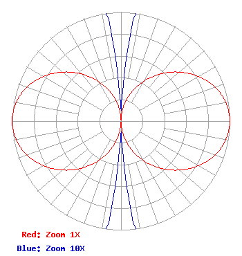 | ||||||||||||||||||
| Azimuth | Ratio | Azimuth | Ratio | Azimuth | Ratio | Azimuth | Ratio | ||||||||||||
| 0 | 0.010 | 10 | 0.139 | 20 | 0.280 | 30 | 0.423 | ||||||||||||
| 40 | 0.564 | 50 | 0.700 | 60 | 0.820 | 70 | 0.916 | ||||||||||||
| 80 | 0.978 | 90 | 1.000 | 100 | 0.978 | 110 | 0.916 | ||||||||||||
| 120 | 0.820 | 130 | 0.700 | 140 | 0.564 | 150 | 0.423 | ||||||||||||
| 160 | 0.280 | 170 | 0.139 | 180 | 0.010 | 190 | 0.139 | ||||||||||||
| 200 | 0.280 | 210 | 0.423 | 220 | 0.564 | 230 | 0.700 | ||||||||||||
| 240 | 0.820 | 250 | 0.916 | 260 | 0.978 | 270 | 1.000 | ||||||||||||
| 280 | 0.978 | 290 | 0.916 | 300 | 0.820 | 310 | 0.700 | ||||||||||||
| 320 | 0.564 | 330 | 0.423 | 340 | 0.280 | 350 | 0.139 | ||||||||||||
Structure Registration Number 1302823 Structure Type: GTOWER Registered To: K2 Towers III, LLC Structure Address: 337 Pine Street (no. 2) Port Neches, TX County Name: Jefferson County ASR Issued: 02/04/2022 Site Elevation: 4.2 m (14 ft.) Structure Height: 115.8 m (380 ft.) Height Overall: 115.8 m (380 ft.) Overall Height AMSL: 120 m (394 ft.) FAA Determination: 04/19/2017 FAA Study #: 2017-ASW-2614-OE Paint & Light FAA Chapters: NONE 29-58-36.1 N 93-56-00.8 W (NAD 83) 29-58-35.3 N 93-56-00.2 W (Converted to NAD 27) |
888c 8th Avenue Suite 733 New York, NY 10019 Phone: 212-580-1349 Limited Liability Company | Title: Member Date: 01/07/2022 Application Certifier Sagamorehill Of Beaumont, Llc 888c 8th Avenue Suite 733 New York, NY 10019 Applicant Clarence M Beverage Communications Technologies, Inc. 23 Binsted Drive Medford, NJ 08055 Broadcast Engineering Consultant Aaron P Shainis Shainis & Peltzman, Chartered 1850 M Street Nw Suite 240 Washington, DC 20036 FCC Legal Counsel | |||||||||||||||||