
FCCInfo.com
A Service of Cavell, Mertz & Associates, Inc.
(855) FCC-INFO
|
|
|
|
|
||||||||||||||||
|
|
Status: License Application Accepted: 01/07/2022 License Expires: 04/01/2030 File Number: -0000179175 FCC Website Links: LMS Facility Details This Application Other KXSH-LD Applications Including Superseded Applications Mailing Address Correspondence for KXSH-LD Correspondence related to application -0000179175 Service Contour - Open Street Map or USGS Map (51 dBu) Service Contour - KML / Google Earth (51 dBu) Rabbit Ears Info Search for KXSH-LD Site Location: 43-38-34.0 N 92-31-36.0 W (NAD 83) Site Location: 43-38-34.1 N 92-31-35.4 W (Converted to NAD 27) ERP: 8.7 kW Polarization: Horizontally polarized Electrical Beam Tilt: 0.5 degrees R/C AGL: 345.5 m (1134 ft.) R/C AMSL: 757 m (2484 ft.) Emission Mask: Full Service Site Elevation: 411.5 m. (1350 ft.) Height Overall*: 350.2 m (1149 ft.) (* As Filed In This Application, may differ from ASR Data, Below.) Directional Antenna - Antenna Make/Model: Dielectric TUP-C2-6-1 Antenna ID: 1009139 Polarization: Horizontally polarized | ||||||||||||||||||
| Antenna Data for Antenna Id: 1009139 KXSH-LD LD File: -0000179175 Dielectric - TUP-C2-6-1 Service: LD Standard Pattern: N | 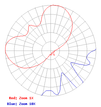 | ||||||||||||||||||
| Azimuth | Ratio | Azimuth | Ratio | Azimuth | Ratio | Azimuth | Ratio | ||||||||||||
| 0 | 0.983 | 10 | 1.000 | 20 | 0.960 | 30 | 0.870 | ||||||||||||
| 40 | 0.747 | 50 | 0.578 | 60 | 0.409 | 70 | 0.248 | ||||||||||||
| 80 | 0.149 | 90 | 0.095 | 100 | 0.081 | 110 | 0.090 | ||||||||||||
| 120 | 0.053 | 130 | 0.072 | 140 | 0.135 | 150 | 0.060 | ||||||||||||
| 160 | 0.067 | 170 | 0.097 | 180 | 0.088 | 190 | 0.096 | ||||||||||||
| 200 | 0.148 | 210 | 0.246 | 220 | 0.407 | 230 | 0.581 | ||||||||||||
| 240 | 0.745 | 250 | 0.853 | 260 | 0.941 | 270 | 0.995 | ||||||||||||
| 280 | 0.971 | 290 | 0.852 | 300 | 0.659 | 310 | 0.644 | ||||||||||||
| 319 | 0.720 | 320 | 0.718 | 330 | 0.618 | 340 | 0.644 | ||||||||||||
| 350 | 0.855 | ||||||||||||||||||
Structure Registration Number 1063897 Structure Type: GTOWER Registered To: Gray Media Group, Inc. Structure Address: 0.22 Mi Se Of 760 Ave. & 200 St. Intersection Grand Meadow, MN County Name: Mower County ASR Issued: 08/03/2021 Date Built: 09/01/1998 Site Elevation: 411.5 m (1350 ft.) Structure Height: 341 m (1119 ft.) Height Overall: 350.2 m (1149 ft.) Overall Height AMSL: 761.7 m (2499 ft.) FAA Determination: 05/04/2015 FAA Study #: 2015-AGL-4952-OE FAA Circular #: 70/7460-1K Paint & Light FAA Chapters: 3, 4, 5, 12 FAA CHAPTERS 3,4,5,12; 70/7460-1K WITH BIRD LIGHTING DEVIATION SPECIAL CONDITION. PRIOR STUDY 2014-AGL-14836-OE 43-38-34.0 N 92-31-36.0 W (NAD 83) 43-38-34.1 N 92-31-35.4 W (Converted to NAD 27) |
525 Blackburn Drive Augusta, GA 30907 Phone: 202-747-1694 Limited Liability Company | Title: Member Date: 01/07/2022 Application Certifier Sagamorehill Of Minneapolis, Llc 525 Blackburn Drive Augusta, GA 30907 Applicant Joseph M. Davis, P.E. Chesapeake Rf Consultants, Llc 207 Old Dominion Road Yorktown, VA 23692 Consulting Engineer Scott Woodworth Edinger Associates Pllc 1725 I Street, Nw Suite 300 Washington, DC 20006 | |||||||||||||||||