
FCCInfo.com
A Service of Cavell, Mertz & Associates, Inc.
(855) FCC-INFO
|
|
WNPX-LD from 02/28/2003 WNPX-LD from 12/18/1998 WNPX-LD from 03/06/1989 WNPX-LD from 12/19/1988 WNPX-LD from 05/18/1987 |
|
|
||||||||||||||||
|
|
Status: License Application Accepted: 01/07/2022 License Expires: 08/02/2021 File Number: -0000179242 FCC Website Links: LMS Facility Details This Application Other WNPX-LD Applications Including Superseded Applications Mailing Address Correspondence for WNPX-LD Correspondence related to application -0000179242 Service Contour - Open Street Map or USGS Map (51 dBu) Service Contour - KML / Google Earth (51 dBu) Rabbit Ears Info Search for WNPX-LD Site Location: 35-55-20.1 N 86-42-46.2 W (NAD 83) Site Location: 35-55-19.9 N 86-42-46.2 W (Converted to NAD 27) ERP: 12 kW Polarization: Circularly polarized R/C AGL: 84 m (276 ft.) R/C AMSL: 449.2 m (1474 ft.) Emission Mask: Full Service Site Elevation: 365.2 m. (1198 ft.) Height Overall*: 106.4 m (349 ft.) (* As Filed In This Application, may differ from ASR Data, Below.) Directional Antenna - Antenna Make/Model: Systems With Reliability Inc. SWED12WLR-CP Antenna ID: 1009145 Polarization: Circularly polarized | ||||||||||||||||||
| Antenna Data for Antenna Id: 1009145 WNPX-LD LD File: -0000179242 Systems With Reliability Inc. - SWED12WLR-CP Service: LD Standard Pattern: N | 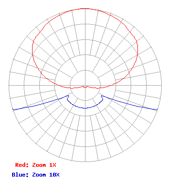 | ||||||||||||||||||
| Azimuth | Ratio | Azimuth | Ratio | Azimuth | Ratio | Azimuth | Ratio | ||||||||||||
| 0 | 1.000 | 10 | 0.990 | 20 | 0.970 | 30 | 0.950 | ||||||||||||
| 40 | 0.910 | 50 | 0.880 | 60 | 0.790 | 70 | 0.660 | ||||||||||||
| 80 | 0.510 | 90 | 0.350 | 100 | 0.210 | 110 | 0.090 | ||||||||||||
| 120 | 0.030 | 130 | 0.030 | 140 | 0.030 | 150 | 0.030 | ||||||||||||
| 160 | 0.030 | 170 | 0.030 | 180 | 0.030 | 190 | 0.030 | ||||||||||||
| 200 | 0.030 | 210 | 0.030 | 220 | 0.030 | 230 | 0.030 | ||||||||||||
| 240 | 0.030 | 250 | 0.090 | 260 | 0.210 | 270 | 0.350 | ||||||||||||
| 280 | 0.510 | 290 | 0.660 | 300 | 0.790 | 310 | 0.880 | ||||||||||||
| 320 | 0.910 | 330 | 0.950 | 340 | 0.970 | 350 | 0.990 | ||||||||||||
Structure Registration Number 1037570 Structure Type: LTOWER Registered To: American Towers LLC Structure Address: 9623 Clovercroft Road (#009075) Nolensville, TN County Name: Williamson County ASR Issued: 01/06/2023 Date Built: 01/20/2003 Site Elevation: 365.2 m (1198 ft.) Structure Height: 88.7 m (291 ft.) Height Overall: 106.4 m (349 ft.) Overall Height AMSL: 471.6 m (1547 ft.) FAA Determination: 12/27/2022 FAA Study #: 2022-ASO-9779-OE FAA Circular #: 70/7460-1K Paint & Light FAA Chapters: 4, 8, 12 OM&L to remain the same as prior study = A MED-DUAL SYSTEM 35-55-20.1 N 86-42-46.2 W (NAD 83) 35-55-19.9 N 86-42-46.2 W (Converted to NAD 27) |
3901 Highway121 South Bedford, TX 76021 Phone: 817-571-1229 Not-for-Profit | Title: Vice President Date: 01/07/2022 Application Certifier WORD OF GOD FELLOWSHIP, INC. Word Of God Fellowship, Inc. 3901 Highway121 South Bedford, TX 76021 Applicant Mark B Denbo Smithwick & Belendiuk, P.c. 5028 Wisconsin Avenue, N.w., Suite 301 Washington, DC 20016 Attorney Richard C Goetz R & L Media Systems 135 N Country Club Dr Hendersonville, TN 37075 Broadcast Consultant | |||||||||||||||||