
FCCInfo.com
A Service of Cavell, Mertz & Associates, Inc.
(855) FCC-INFO
|
|
|
|
|
||||||||||||||||
|
|
Status: License Application Accepted: 01/10/2022 License Expires: 10/03/2022 File Number: -0000179470 FCC Website Links: LMS Facility Details This Application Other KXCY-LD Applications Including Superseded Applications Mailing Address Correspondence for KXCY-LD Correspondence related to application -0000179470 Service Contour - Open Street Map or USGS Map (51 dBu) Service Contour - KML / Google Earth (51 dBu) Rabbit Ears Info Search for KXCY-LD Site Location: 41-09-34.5 N 104-43-19.8 W (NAD 83) Site Location: 41-09-34.6 N 104-43-17.9 W (Converted to NAD 27) ERP: 4.66 kW Polarization: Elliptically polarized Electrical Beam Tilt: 1.0 degree R/C AGL: 30.5 m (100 ft.) R/C AMSL: 1895.2 m (6218 ft.) Emission Mask: Full Service Site Elevation: 1864.7 m. (6118 ft.) Height Overall*: 56 m (184 ft.) (* As Filed In This Application, may differ from ASR Data, Below.) Directional Antenna - Antenna Make/Model: ATC ATC-BCE46M-VO-18 Antenna ID: 1009167 Polarization: Elliptically polarized | ||||||||||||||||||
| Antenna Data for Antenna Id: 1009167 KXCY-LD LD File: -0000179470 ATC - ATC-BCE46M-VO-18 Service: LD Standard Pattern: N Pattern and Field Values Include a 270.0° Clockwise Rotation | 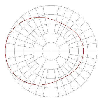 | ||||||||||||||||||
| Azimuth | Ratio | Azimuth | Ratio | Azimuth | Ratio | Azimuth | Ratio | ||||||||||||
| 0 | 0.694 | 10 | 0.663 | 20 | 0.645 | 30 | 0.641 | ||||||||||||
| 40 | 0.647 | 50 | 0.661 | 60 | 0.679 | 70 | 0.694 | ||||||||||||
| 80 | 0.705 | 90 | 0.709 | 100 | 0.705 | 110 | 0.694 | ||||||||||||
| 120 | 0.678 | 130 | 0.661 | 140 | 0.647 | 150 | 0.641 | ||||||||||||
| 160 | 0.645 | 170 | 0.663 | 180 | 0.694 | 190 | 0.734 | ||||||||||||
| 200 | 0.781 | 210 | 0.829 | 220 | 0.876 | 230 | 0.918 | ||||||||||||
| 240 | 0.953 | 250 | 0.979 | 260 | 0.995 | 270 | 1.000 | ||||||||||||
| 280 | 0.995 | 290 | 0.979 | 300 | 0.953 | 310 | 0.918 | ||||||||||||
| 320 | 0.876 | 330 | 0.829 | 340 | 0.781 | 350 | 0.734 | ||||||||||||
Structure Registration Number 1008318 Structure Type: Registered To: RF Towers, LLC Structure Address: 7011 Dell Range Blvd Cheyenne, WY County Name: Laramie County ASR Issued: 02/10/2024 Date Built: 12/19/2012 Site Elevation: 1864.7 m (6118 ft.) Structure Height: 55.2 m (181 ft.) Height Overall: 56 m (184 ft.) Overall Height AMSL: 1920.7 m (6302 ft.) FAA Determination: 04/09/2012 FAA Study #: 2012-ANM-789-OE FAA Circular #: 70/7460-1K Paint & Light FAA Chapters: 4, 8, 12 PRIOR STUDY 2004-ANM-1105-OE 41-09-34.5 N 104-43-19.8 W (NAD 83) 41-09-34.6 N 104-43-17.9 W (Converted to NAD 27) |
38955 Hills Tech Dr. Farmington Hills, MI 48331 Phone: 248-536-0776 Limited Liability Company | Title: President Date: 01/10/2022 Application Certifier Roseland Broadcasting, Inc. 888 8th Avenue #733 New York, NY 10019 Applicant Timothy Z Sawyer T Z Sawyer Technical Consultants 2130 Hutchison Grove Court Suite 100 Falls Church, VA 22043 Technical Consultant Aaron P Shainis Shainis & Peltzman, Chartered 1850 M St Nw Suite 240 Washington, DC 20036 Legal Counsel | |||||||||||||||||