
FCCInfo.com
A Service of Cavell, Mertz & Associates, Inc.
(855) FCC-INFO
|
|
|
Post-repack Channel 13 Virtual Channel 46 |
|
||||||||||||||||
|
|
Repacking Information: Pre-Repack Channel: 10 Post-Repack Channel: 13 Post-Repack ERP: 30 kW Phase: 10 Completion Deadline: 7/3/2020 Find nearby TV Facilities Status: License Application Accepted: 01/10/2022 License Expires: 10/01/2028 File Number: -0000179139 FCC Website Links: LMS Facility Details This Application Other WVFX Applications Including Superseded Applications Mailing Address Correspondence for WVFX Correspondence related to application -0000179139 Service Contour - Open Street Map or USGS Map (36 dBu) Service Contour - KML / Google Earth (36 dBu) Public Inspection Files History Cards for WVFX Rabbit Ears Info Search for WVFX Site Location: 39-18-02.0 N 80-20-36.0 W (NAD 83) Site Location: 39-18-01.7 N 80-20-36.7 W (Converted to NAD 27) ERP: 32 kW Polarization: Elliptically polarized HAAT: 242.7 m (796 ft.) Electrical Beam Tilt: 1.25 degrees R/C AGL: 187.5 m (615 ft.) R/C AMSL: 602 m (1975 ft.) Site Elevation: 414.5 m. (1360 ft.) Height Overall*: 192.7 m (632 ft.) (* As Filed In This Application, may differ from ASR Data, Below.) Directional Antenna - Antenna Make/Model: Electronics Research Inc. ATW5V5-ETP-13H Antenna ID: 1009164 Polarization: Elliptically polarized | ||||||||||||||||||
| Antenna Data for Antenna Id: 1009164 WVFX DT File: -0000179139 Electronics Research Inc. - ATW5V5-ETP-13H Service: DT Standard Pattern: N | 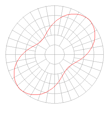 | ||||||||||||||||||
| Azimuth | Ratio | Azimuth | Ratio | Azimuth | Ratio | Azimuth | Ratio | ||||||||||||
| 0 | 0.654 | 10 | 0.765 | 20 | 0.867 | 30 | 0.945 | ||||||||||||
| 40 | 0.989 | 45 | 1.000 | 50 | 0.989 | 60 | 0.945 | ||||||||||||
| 70 | 0.867 | 80 | 0.765 | 90 | 0.655 | 100 | 0.551 | ||||||||||||
| 110 | 0.469 | 120 | 0.415 | 130 | 0.389 | 140 | 0.390 | ||||||||||||
| 150 | 0.416 | 160 | 0.469 | 170 | 0.551 | 180 | 0.654 | ||||||||||||
| 190 | 0.765 | 200 | 0.867 | 210 | 0.945 | 220 | 0.988 | ||||||||||||
| 225 | 1.000 | 230 | 0.989 | 240 | 0.946 | 250 | 0.867 | ||||||||||||
| 260 | 0.765 | 270 | 0.655 | 280 | 0.551 | 290 | 0.469 | ||||||||||||
| 300 | 0.415 | 310 | 0.389 | 320 | 0.390 | 330 | 0.416 | ||||||||||||
| 340 | 0.469 | 350 | 0.551 | ||||||||||||||||
Structure Registration Number 1034466 Structure Type: TOWER Registered To: Gray Media Group, Inc. Structure Address: North 16 Extended Clarksburg, WV County Name: Harrison County ASR Issued: 09/09/2020 Date Built: 10/26/1992 Site Elevation: 414.5 m (1360 ft.) Structure Height: 182.9 m (600 ft.) Height Overall: 192.7 m (632 ft.) Overall Height AMSL: 607.2 m (1992 ft.) FAA Determination: 10/05/1979 FAA Study #: 79-AEA-704-OE Paint & Light FAA Chapters: 1, 3, 5, 14, 21 RED LIGHTS/PAINT 39-18-02.0 N 80-20-36.0 W (NAD 83) 39-18-01.7 N 80-20-36.7 W (Converted to NAD 27) |
4370 Peachtree Road Atlanta, GA 30319 Phone: 404-266-8333 Limited Liability Company | Title: Assistant Secretary Date: 01/10/2022 Application Certifier Gray Television Licensee, Llc 4370 Peachtree Road, Ne Atlanta, GA 30319 Applicant Joan Stewart Wiley Rein Llp 2050 M Street, Nw Washington, DC 20036 Joseph M. Davis, P.E. Chesapeake Rf Consultants, Llc 207 Old Dominion Road Yorktown, VA 23692 Consulting Engineer DAVID BURKE Gray Television Licensee, Llc 201 Monroe St. Montgomery, AL 36104 SENIOR VICE PRESIDENT AND CTO | |||||||||||||||||