
FCCInfo.com
A Service of Cavell, Mertz & Associates, Inc.
(855) FCC-INFO
|
|
|
|
|
||||||||||||||||
|
|
Status: License Application Accepted: 01/10/2022 License Expires: 10/03/2022 File Number: -0000179556 FCC Website Links: LMS Facility Details This Application Other K06QX-D Applications Including Superseded Applications Mailing Address Correspondence for K06QX-D Correspondence related to application -0000179556 Service Contour - Open Street Map or USGS Map (43 dBu) Service Contour - KML / Google Earth (43 dBu) Rabbit Ears Info Search for K06QX-D Site Location: 39-35-02.7 N 119-47-55.5 W (NAD 83) Site Location: 39-35-03.0 N 119-47-51.8 W (Converted to NAD 27) ERP: 0.1 kW Polarization: Horizontally polarized R/C AGL: 6 m (20 ft.) R/C AMSL: 1671.3 m (5483 ft.) Emission Mask: Simple Site Elevation: 1665.3 m. (5464 ft.) Height Overall*: 61.6 m (202 ft.) (* As Filed In This Application, may differ from ASR Data, Below.) Directional Antenna - Antenna Make/Model: SAM SAM-137(v) Antenna ID: 1009173 Polarization: Horizontally polarized | ||||||||||||||||||
| Antenna Data for Antenna Id: 1009173 K06QX-D LD File: -0000179556 SAM - SAM-137(v) Service: LD Standard Pattern: N Pattern and Field Values Include a 180° Clockwise Rotation | 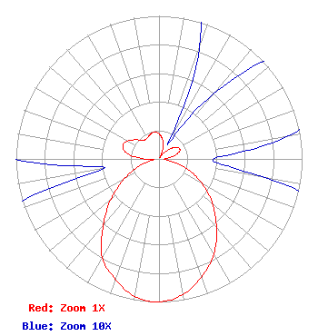 | ||||||||||||||||||
| Azimuth | Ratio | Azimuth | Ratio | Azimuth | Ratio | Azimuth | Ratio | ||||||||||||
| 0 | 0.177 | 10 | 0.140 | 20 | 0.083 | 30 | 0.012 | ||||||||||||
| 40 | 0.060 | 50 | 0.117 | 60 | 0.156 | 70 | 0.153 | ||||||||||||
| 80 | 0.092 | 90 | 0.038 | 100 | 0.075 | 110 | 0.216 | ||||||||||||
| 120 | 0.349 | 130 | 0.488 | 140 | 0.625 | 150 | 0.767 | ||||||||||||
| 160 | 0.875 | 170 | 0.963 | 180 | 1.000 | 190 | 0.977 | ||||||||||||
| 200 | 0.894 | 210 | 0.794 | 220 | 0.605 | 230 | 0.438 | ||||||||||||
| 240 | 0.279 | 250 | 0.144 | 260 | 0.039 | 270 | 0.104 | ||||||||||||
| 280 | 0.227 | 290 | 0.269 | 300 | 0.253 | 310 | 0.208 | ||||||||||||
| 320 | 0.170 | 330 | 0.168 | 340 | 0.181 | 350 | 0.190 | ||||||||||||
Structure Registration Number 1025101 Structure Type: GTOWER Registered To: American Towers LLC Structure Address: 2030 W. 1st Avenue (east Red Peak 2 #8742) Sun Valley, NV County Name: Washoe County ASR Issued: 06/29/2017 Date Built: 03/01/2002 Site Elevation: 1665.3 m (5464 ft.) Structure Height: 59.7 m (196 ft.) Height Overall: 61.6 m (202 ft.) Overall Height AMSL: 1726.9 m (5666 ft.) FAA Determination: 06/28/2017 FAA Study #: 2016-AWP-4505-OE FAA Circular #: 70/7460-1K Paint & Light FAA Chapters: 4, 8, 12 OM&L to remain the same as prior study = A MED-DUAL SYSTEM 39-35-02.7 N 119-47-55.5 W (NAD 83) 39-35-03.0 N 119-47-51.8 W (Converted to NAD 27) |
1498 Buford Hwy Ste C 275 Sugar Hill, GA 30518 Phone: 770-771-1644 Limited Liability Company | Title: President Date: 01/10/2022 Application Certifier Dnv Spectrum Holdings, Llc 7742 Spalding Drive Suite 475 Norcross, GA 30092 Applicant Susan Hanson B W St Clair 2305 Vida Shaw Rd New Iberia, NV 89503 | |||||||||||||||||