
FCCInfo.com
A Service of Cavell, Mertz & Associates, Inc.
(855) FCC-INFO
|
|
KOHA-LD from 10/31/1996 KOHA-LD from 10/23/1996 KOHA-LD from 02/05/1996 KOHA-LD from 12/01/1995 KOHA-LD from 08/03/1992 |
|
|
||||||||||||||||
|
|
Status: License Application Accepted: 01/26/2022 License Expires: 06/01/2022 File Number: -0000181422 FCC Website Links: LMS Facility Details This Application Other KOHA-LD Applications Including Superseded Applications Mailing Address Correspondence for KOHA-LD Correspondence related to application -0000181422 Service Contour - Open Street Map or USGS Map (51 dBu) Service Contour - KML / Google Earth (51 dBu) Rabbit Ears Info Search for KOHA-LD Site Location: 41-13-29.6 N 95-57-11.6 W (NAD 83) Site Location: 41-13-29.6 N 95-57-10.5 W (Converted to NAD 27) ERP: 15 kW Polarization: Elliptically polarized Electrical Beam Tilt: 0.5 degrees R/C AGL: 117.3 m (385 ft.) R/C AMSL: 480.3 m (1576 ft.) Emission Mask: Full Service Site Elevation: 363 m. (1191 ft.) Height Overall*: 131 m (430 ft.) (* As Filed In This Application, may differ from ASR Data, Below.) Directional Antenna - Antenna Make/Model: ATC ATC-BCE28M-V3-27 Antenna ID: 1008471 Polarization: Elliptically polarized | ||||||||||||||||||
| Antenna Data for Antenna Id: 1008471 KOHA-LD LD File: -0000181422 ATC - ATC-BCE28M-V3-27 Service: LD Standard Pattern: Y Pattern and Field Values Include a 240° Clockwise Rotation | 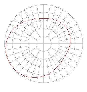 | ||||||||||||||||||
| Azimuth | Ratio | Azimuth | Ratio | Azimuth | Ratio | Azimuth | Ratio | ||||||||||||
| 0 | 0.641 | 10 | 0.647 | 20 | 0.661 | 30 | 0.679 | ||||||||||||
| 40 | 0.694 | 50 | 0.705 | 60 | 0.709 | 70 | 0.705 | ||||||||||||
| 80 | 0.694 | 90 | 0.678 | 100 | 0.661 | 110 | 0.647 | ||||||||||||
| 120 | 0.641 | 130 | 0.645 | 140 | 0.663 | 150 | 0.694 | ||||||||||||
| 160 | 0.734 | 170 | 0.781 | 180 | 0.829 | 190 | 0.876 | ||||||||||||
| 200 | 0.918 | 210 | 0.953 | 220 | 0.979 | 230 | 0.995 | ||||||||||||
| 240 | 1.000 | 250 | 0.995 | 260 | 0.979 | 270 | 0.953 | ||||||||||||
| 280 | 0.918 | 290 | 0.876 | 300 | 0.829 | 310 | 0.781 | ||||||||||||
| 320 | 0.734 | 330 | 0.694 | 340 | 0.663 | 350 | 0.645 | ||||||||||||
Structure Registration Number 1223431 Structure Type: TOWER Registered To: Global Tower, LLC. through American Towers, LLC Structure Address: 2808 "b" Street Omaha, NE County Name: Douglas County ASR Issued: 09/02/2014 Date Built: 03/14/2001 Site Elevation: 363 m (1191 ft.) Structure Height: 121.9 m (400 ft.) Height Overall: 131 m (430 ft.) Overall Height AMSL: 494 m (1621 ft.) FAA Determination: 10/05/2001 FAA Study #: 01-ACE-2153-OE FAA Circular #: 70/7460-1K Paint & Light FAA Chapters: 4, 8, 12 PRIOR STUDY 00-ACE-0423-OE 41-13-29.6 N 95-57-11.6 W (NAD 83) 41-13-29.6 N 95-57-10.5 W (Converted to NAD 27) |
214 N. 7th Street Suite 1 Norfolk, NE 68702 Phone: 402-371-0100 Limited Liability Company | Title: Managing Member Date: 01/26/2022 Application Certifier FLOOD COMMUNICATIONS OF OMAHA, LLC Flood Communications Of Omaha, Llc 214 N. 7th Street Norfolk, NE 68702 Applicant Clarence M. Beverage Communications Technologies, Inc. 23 Binsted Drive Medford, NJ 08055 Broadcast Engineering Consultant Matthew H. McCormick Fletcher, Heald & Hildreth, Plc 1300 N 17th Street 11th Floor Arlington, VA 22209 | |||||||||||||||||