
FCCInfo.com
A Service of Cavell, Mertz & Associates, Inc.
(855) FCC-INFO
|
|
|
Post-repack Channel 13 Virtual Channel 52 |
|
||||||||||||||||
|
|
WNYI is a channel sharing host for WDSS-LD, Syracuse, New York Repacking Information: Pre-Repack Channel: 20 Post-Repack Channel: 13 Post-Repack ERP: 2.73 kW Phase: 4 Completion Deadline: 8/2/2019 Upstream/Downstream Dependencies Other Linked Stations Find nearby TV Facilities Status: License Application Accepted: 01/27/2022 License Expires: 06/01/2023 File Number: -0000181680 FCC Website Links: LMS Facility Details This Application Other WNYI Applications Including Superseded Applications Mailing Address Correspondence for WNYI Correspondence related to application -0000181680 Service Contour - Open Street Map or USGS Map (36 dBu) Service Contour - KML / Google Earth (36 dBu) Public Inspection Files Rabbit Ears Info Search for WNYI Site Location: 42-48-05.2 N 76-26-12.8 W (NAD 83) Site Location: 42-48-05.0 N 76-26-14.0 W (Converted to NAD 27) ERP: 28 kW Polarization: Horizontally polarized HAAT: 260 m (853 ft.) R/C AGL: 122 m (400 ft.) R/C AMSL: 598.7 m (1964 ft.) Site Elevation: 476.7 m. (1564 ft.) Height Overall*: 152.4 m (500 ft.) (* As Filed In This Application, may differ from ASR Data, Below.) Directional Antenna - Antenna Make/Model: Systems With Reliability Inc. (2) SWR-SWDDP 60-300 Antenna ID: 1009239 Polarization: Horizontally polarized | ||||||||||||||||||
| Antenna Data for Antenna Id: 1009239 WNYI DT File: -0000181680 Systems With Reliability Inc. - (2) SWR-SWDDP 60-300 Service: DT Standard Pattern: N Pattern and Field Values Include a 155° Clockwise Rotation | 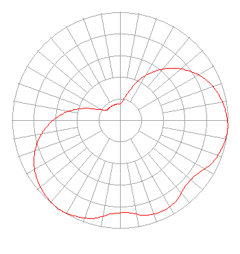 | ||||||||||||||||||
| Azimuth | Ratio | Azimuth | Ratio | Azimuth | Ratio | Azimuth | Ratio | ||||||||||||
| 5 | 0.160 | 15 | 0.240 | 25 | 0.400 | 35 | 0.550 | ||||||||||||
| 45 | 0.680 | 55 | 0.790 | 65 | 0.880 | 75 | 0.940 | ||||||||||||
| 85 | 0.980 | 95 | 1.000 | 105 | 0.980 | 115 | 0.940 | ||||||||||||
| 125 | 0.870 | 135 | 0.860 | 145 | 0.910 | 155 | 0.930 | ||||||||||||
| 165 | 0.910 | 175 | 0.860 | 185 | 0.870 | 195 | 0.940 | ||||||||||||
| 205 | 0.980 | 215 | 1.000 | 225 | 0.980 | 235 | 0.940 | ||||||||||||
| 245 | 0.880 | 255 | 0.790 | 265 | 0.680 | 275 | 0.550 | ||||||||||||
| 285 | 0.400 | 295 | 0.240 | 305 | 0.160 | 315 | 0.150 | ||||||||||||
| 325 | 0.150 | 335 | 0.150 | 345 | 0.150 | 355 | 0.150 | ||||||||||||
Structure Registration Number 1005754 Structure Type: GTOWER Registered To: American Towers LLC Structure Address: Quarry Rd., Near Pennyville Ln. (311093) Moravia, NY County Name: Cayuga County ASR Issued: 01/07/2014 Date Built: 06/26/2015 Site Elevation: 476.7 m (1564 ft.) Structure Height: 151.2 m (496 ft.) Height Overall: 152.4 m (500 ft.) Overall Height AMSL: 629.1 m (2064 ft.) FAA Determination: 11/14/2011 FAA Study #: 2011-AEA-4453-OE FAA Circular #: 70/7460-1K Paint & Light FAA Chapters: 4, 8, 12 PRIOR STUDY 2011-AEA-3732-OE 42-48-05.2 N 76-26-12.8 W (NAD 83) 42-48-05.0 N 76-26-14.0 W (Converted to NAD 27) |
3901 Highway 121 South Bedford, TX 76021 Phone: 817-571-1229 Not-for-Profit | Title: Corporate Secretary Date: 01/27/2022 Application Certifier Word Of God Fellowship, Inc. 3901 Highway 121 South Bedford, TX 76021 Applicant Ari Meltzer, Esq Wiley Rein Llp 2050 M Street Nw Washington, DC 20036 | |||||||||||||||||