
FCCInfo.com
A Service of Cavell, Mertz & Associates, Inc.
(855) FCC-INFO
|
|
KVEO-TV from 12/10/1981 KVEO-TV from 11/10/1980 |
Virtual Channel 23 |  |
|
|||||||||||||||||||||
|
|
Repacking Information: No changes Status: STA – Special Temporary Authority Application Accepted: 02/11/2022 STA Expires: 09/06/2022 File Number: -0000184749 FCC Website Links: LMS Facility Details This Application Other KVEO-TV Applications Including Superseded Applications Mailing Address Correspondence for KVEO-TV Correspondence related to application -0000184749 Service Contour - Open Street Map or USGS Map (41 dBu) Service Contour - KML / Google Earth (41 dBu) Public Inspection Files History Cards for KVEO-TV Rabbit Ears Info Search for KVEO-TV Site Location: 26-06-02.3 N 97-50-21.5 W (NAD 83) Site Location: 26-06-01.0 N 97-50-20.5 W (Converted to NAD 27) ERP: 500 kW Polarization: Horizontally polarized HAAT: 445 m (1460 ft.) Electrical Beam Tilt: 0.75 degrees R/C AGL: 446.2 m (1464 ft.) R/C AMSL: 463.3 m (1520 ft.) Site Elevation: 17.1 m. (56 ft.) Height Overall*: 454.5 m (1491 ft.) (* As Filed In This Application, may differ from ASR Data, Below.) Directional Antenna - Antenna Make/Model: Andrew ATW27H5-HTC1L-23H Antenna ID: 1009281 Polarization: Horizontally polarized | ||||||||||||||||||||||||
| Antenna Data for Antenna Id: 1009281 KVEO-TV DT File: -0000184749 Andrew - ATW27H5-HTC1L-23H Service: DT Standard Pattern: N | 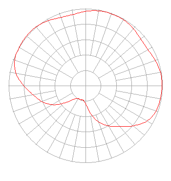 | ||||||||||||||||||||||||
| Azimuth | Ratio | Azimuth | Ratio | Azimuth | Ratio | Azimuth | Ratio | ||||||||||||||||||
| 0 | 0.963 | 10 | 0.985 | 20 | 0.992 | 30 | 0.987 | ||||||||||||||||||
| 40 | 0.966 | 50 | 0.938 | 60 | 0.935 | 70 | 0.963 | ||||||||||||||||||
| 80 | 0.989 | 90 | 0.994 | 100 | 0.987 | 110 | 0.974 | ||||||||||||||||||
| 120 | 0.921 | 130 | 0.811 | 140 | 0.695 | 150 | 0.604 | ||||||||||||||||||
| 160 | 0.504 | 170 | 0.363 | 180 | 0.235 | 190 | 0.190 | ||||||||||||||||||
| 200 | 0.195 | 210 | 0.193 | 220 | 0.228 | 230 | 0.348 | ||||||||||||||||||
| 240 | 0.495 | 250 | 0.602 | 260 | 0.691 | 270 | 0.803 | ||||||||||||||||||
| 280 | 0.917 | 290 | 0.979 | 300 | 0.993 | 310 | 1.000 | ||||||||||||||||||
| 320 | 0.996 | 330 | 0.972 | 340 | 0.941 | 350 | 0.937 | ||||||||||||||||||
Structure Registration Number 1222106 Structure Type: GTOWER Registered To: Pinnacle Towers LLC Structure Address: 31578 County Road 629 La Feria, TX County Name: Cameron County ASR Issued: 12/01/2021 Date Built: 08/20/2001 Site Elevation: 17.1 m (56 ft.) Structure Height: 427.6 m (1403 ft.) Height Overall: 454.5 m (1491 ft.) Overall Height AMSL: 471.6 m (1547 ft.) FAA Determination: 04/01/2010 FAA Study #: 2009-ASW-5731-OE FAA Circular #: 70/7460-1K Paint & Light FAA Chapters: 4, 9, 12 OM&L to remain the same as prior study = A HIGH-DUAL SYSTEM 26-06-02.3 N 97-50-21.5 W (NAD 83) 26-06-01.0 N 97-50-20.5 W (Converted to NAD 27) |
545 E. John Carpenter Freeway Suite 700 Irving, TX 75062 Phone: 972-373-8800 Corporation | Title: General Counsel Date: 02/11/2022 Application Certifier Nexstar Media Inc. 545 E. John Carpenter Freeway Suite 700 Irving, TX 75062 Applicant Elizabeth Ryder Nexstar Media Inc. 545 E. John Carpenter Freeway Suite 700 Irving, TX 75062 General Counsel | |||||||||||||||||||||||
| |||||||||||||||||||||||||