
FCCInfo.com
A Service of Cavell, Mertz & Associates, Inc.
(855) FCC-INFO
|
|
KEVE-LD from 02/06/2009 KEVE-LD from 10/13/1992 KEVE-LD from 09/20/1989 |
|
|
||||||||||||||||
|
|
Status: License Application Accepted: 02/14/2022 License Expires: 02/01/2023 File Number: -0000184826 FCC Website Links: LMS Facility Details This Application Other KEVE-LD Applications Including Superseded Applications Mailing Address Correspondence for KEVE-LD Correspondence related to application -0000184826 Service Contour - Open Street Map or USGS Map (51 dBu) Service Contour - KML / Google Earth (51 dBu) Rabbit Ears Info Search for KEVE-LD Site Location: 45-31-13.0 N 122-44-41.0 W (NAD 83) Site Location: 45-31-13.6 N 122-44-36.6 W (Converted to NAD 27) ERP: 15 kW Polarization: Horizontally polarized Electrical Beam Tilt: 0.5 degrees R/C AGL: 180 m (591 ft.) R/C AMSL: 470.9 m (1545 ft.) Emission Mask: Stringent Site Elevation: 290.9 m. (954 ft.) Height Overall*: 280 m (919 ft.) (* As Filed In This Application, may differ from ASR Data, Below.) Directional Antenna - Antenna Make/Model: Dielectric DLP-12H Antenna ID: 1009289 Polarization: Horizontally polarized | ||||||||||||||||||
| Antenna Data for Antenna Id: 1009289 KEVE-LD LD File: -0000184826 Dielectric - DLP-12H Service: LD Standard Pattern: N Pattern and Field Values Include a 36° Clockwise Rotation | 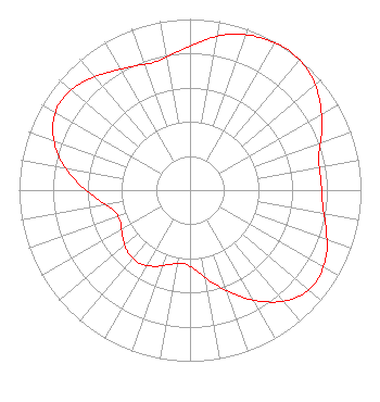 | ||||||||||||||||||
| Azimuth | Ratio | Azimuth | Ratio | Azimuth | Ratio | Azimuth | Ratio | ||||||||||||
| 6 | 0.885 | 16 | 0.949 | 26 | 0.984 | 36 | 1.000 | ||||||||||||
| 46 | 0.977 | 56 | 0.917 | 66 | 0.842 | 76 | 0.776 | ||||||||||||
| 86 | 0.768 | 96 | 0.779 | 106 | 0.828 | 116 | 0.885 | ||||||||||||
| 126 | 0.911 | 136 | 0.880 | 146 | 0.788 | 156 | 0.673 | ||||||||||||
| 166 | 0.560 | 176 | 0.467 | 186 | 0.430 | 196 | 0.452 | ||||||||||||
| 206 | 0.495 | 216 | 0.521 | 226 | 0.511 | 236 | 0.477 | ||||||||||||
| 246 | 0.446 | 256 | 0.468 | 266 | 0.560 | 276 | 0.688 | ||||||||||||
| 286 | 0.810 | 296 | 0.891 | 306 | 0.918 | 316 | 0.885 | ||||||||||||
| 326 | 0.834 | 336 | 0.793 | 346 | 0.777 | 356 | 0.816 | ||||||||||||
Structure Registration Number 1035761 Structure Type: TOWER Registered To: Sinclair Portland Licensee, LLC Structure Address: 225 Nw Skyline Blvd Portland, OR County Name: Multnomah County ASR Issued: 01/10/2017 Date Built: 08/15/1973 Site Elevation: 290.9 m (954 ft.) Structure Height: 247.5 m (812 ft.) Height Overall: 280 m (919 ft.) Overall Height AMSL: 570.9 m (1873 ft.) FAA Determination: 08/15/1996 FAA Study #: 96-ANM-0703-OE FAA Circular #: 70/7460-1J Paint & Light FAA Chapters: 3, 4, 5, 13 45-31-13.0 N 122-44-41.0 W (NAD 83) 45-31-13.6 N 122-44-36.6 W (Converted to NAD 27) |
19800 Oatfield Road Gladstone, OR 97027 Phone: 503-850-3500 Not-for-Profit | Title: President Date: 02/14/2022 Application Certifier SOUTHERN OREGON CONFERENCE ASSN. OF SEVENTH-DAY ADVENTISTS Southern Oregon Conference Assn. Of Seventh-day Adventists 19800 Oatfield Road Gladstone, OR 97027 Applicant DONALD MARTIN Donald E. Martin, P.c. Falls Church, VA 22041 Attorney SCOTT TURPIE Lohnes & Culver, Llc Alexandria, VA 22302 Sr. Technical Consultant | |||||||||||||||||