
FCCInfo.com
A Service of Cavell, Mertz & Associates, Inc.
(855) FCC-INFO
|
|
|
Virtual Channel 19 |
|
||||||||||||||||
|
|
Repacking Information: No changes Status: STA – Special Temporary Authority Application Accepted: 02/15/2022 STA Expires: 07/18/2022 File Number: -0000184838 FCC Website Links: LMS Facility Details This Application Other KWKS Applications Including Superseded Applications Mailing Address Correspondence for KWKS Correspondence related to application -0000184838 Service Contour - Open Street Map or USGS Map (41 dBu) Service Contour - KML / Google Earth (41 dBu) Public Inspection Files Rabbit Ears Info Search for KWKS Site Location: 39-14-31.0 N 101-21-40.0 W (NAD 83) Site Location: 39-14-31.0 N 101-21-38.4 W (Converted to NAD 27) ERP: 464 kW Polarization: Horizontally polarized HAAT: 383 m (1257 ft.) Electrical Beam Tilt: 0.75 degrees R/C AGL: 373.2 m (1224 ft.) R/C AMSL: 1421.7 m (4664 ft.) Site Elevation: 1048.5 m. (3440 ft.) Height Overall*: 380.4 m (1248 ft.) (* As Filed In This Application, may differ from ASR Data, Below.) Directional Antenna - Antenna Make/Model: Electronics Research Inc. ATW20H3-HTT1-19S Antenna ID: 80546 Polarization: Horizontally polarized | ||||||||||||||||||
| Antenna Data for Antenna Id: 80546 KWKS DT File: -0000184838 Electronics Research Inc. - ATW20H3-HTT1-19S Service: DT Standard Pattern: Y Pattern and Field Values Include a 90° Clockwise Rotation | 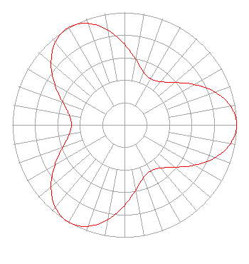 | ||||||||||||||||||
| Azimuth | Ratio | Azimuth | Ratio | Azimuth | Ratio | Azimuth | Ratio | ||||||||||||
| 0 | 0.718 | 10 | 0.587 | 20 | 0.501 | 30 | 0.473 | ||||||||||||
| 40 | 0.501 | 50 | 0.587 | 60 | 0.718 | 70 | 0.856 | ||||||||||||
| 80 | 0.961 | 90 | 1.000 | 100 | 0.961 | 110 | 0.856 | ||||||||||||
| 120 | 0.718 | 130 | 0.587 | 140 | 0.501 | 150 | 0.473 | ||||||||||||
| 160 | 0.501 | 170 | 0.587 | 180 | 0.718 | 190 | 0.856 | ||||||||||||
| 200 | 0.961 | 210 | 1.000 | 220 | 0.961 | 230 | 0.856 | ||||||||||||
| 240 | 0.718 | 250 | 0.587 | 260 | 0.501 | 270 | 0.473 | ||||||||||||
| 280 | 0.501 | 290 | 0.587 | 300 | 0.718 | 310 | 0.856 | ||||||||||||
| 320 | 0.961 | 330 | 1.000 | 340 | 0.961 | 350 | 0.856 | ||||||||||||
Structure Registration Number 1251399 Structure Type: TOWER Registered To: SMOKY HILLS PUBLIC TELEVISION CORP. Structure Address: 8 Mi South Of I-90/brewster, Ks Exit Brewster, KS County Name: Thomas County ASR Issued: 01/24/2007 Date Built: 10/20/2007 Site Elevation: 1048.5 m (3440 ft.) Structure Height: 365.8 m (1200 ft.) Height Overall: 380.4 m (1248 ft.) Overall Height AMSL: 1428.9 m (4688 ft.) FAA Determination: 01/19/2007 FAA Study #: 2007-ACE-116-OE FAA Circular #: 70/7460-1K Paint & Light FAA Chapters: 4, 7, 12 PRIOR STUDY 2006-ACE-104-OE 39-14-31.0 N 101-21-40.0 W (NAD 83) 39-14-31.0 N 101-21-38.4 W (Converted to NAD 27) |
604 Elm Street P.o. Box 9 Bunker Hill, KS 67626 Phone: 785-483-6990 Not-for-Profit | Title: General Manager Date: 02/15/2022 Application Certifier Smoky Hills PBS Smoky Hills Public Television Corp. 604 Elm Street P.o. Box 9 Bunker Hill, KS 67626 Applicant Barry S. Persh Gray Miller Persh Llp 2233 Wisconsin Ave., Nw Suite 226 Washington, DC 20007 | |||||||||||||||||