
FCCInfo.com
A Service of Cavell, Mertz & Associates, Inc.
(855) FCC-INFO
|
|
K20NF-D from 02/25/2010 |
|
|
||||||||||||||||
|
|
Status: License Application Accepted: 03/07/2022 License Expires: 02/01/2023 File Number: -0000185919 FCC Website Links: LMS Facility Details This Application Other K20NF-D Applications Including Superseded Applications Mailing Address Correspondence for K20NF-D Correspondence related to application -0000185919 Service Contour - Open Street Map or USGS Map (51 dBu) Service Contour - KML / Google Earth (51 dBu) Rabbit Ears Info Search for K20NF-D Site Location: 47-37-54.0 N 122-21-03.0 W (NAD 83) Site Location: 47-37-54.6 N 122-20-58.5 W (Converted to NAD 27) ERP: 5 kW Polarization: Horizontally polarized R/C AGL: 150 m (492 ft.) R/C AMSL: 281.2 m (923 ft.) Emission Mask: Full Service Site Elevation: 131.2 m. (430 ft.) Height Overall*: 173.7 m (570 ft.) (* As Filed In This Application, may differ from ASR Data, Below.) Directional Antenna - Antenna Make/Model: Kathrein K72314 Antenna ID: 19753 Polarization: Horizontally polarized
| ||||||||||||||||||
| Antenna Data for Antenna Id: 19753 K20NF-D LD File: -0000185919 Kathrein - K72314 Service: LD Standard Pattern: Y Pattern and Field Values Include a 180° Clockwise Rotation | 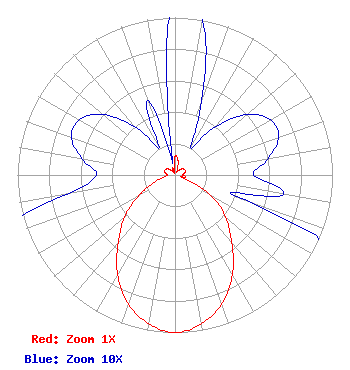 | ||||||||||||||||||
| Azimuth | Ratio | Azimuth | Ratio | Azimuth | Ratio | Azimuth | Ratio | ||||||||||||
| 0 | 0.120 | 10 | 0.100 | 20 | 0.050 | 30 | 0.020 | ||||||||||||
| 40 | 0.040 | 50 | 0.060 | 60 | 0.070 | 70 | 0.070 | ||||||||||||
| 80 | 0.060 | 90 | 0.050 | 100 | 0.070 | 110 | 0.050 | ||||||||||||
| 120 | 0.270 | 130 | 0.420 | 140 | 0.560 | 150 | 0.730 | ||||||||||||
| 160 | 0.870 | 170 | 0.960 | 180 | 1.000 | 190 | 0.960 | ||||||||||||
| 200 | 0.870 | 210 | 0.730 | 220 | 0.560 | 230 | 0.420 | ||||||||||||
| 240 | 0.270 | 250 | 0.150 | 260 | 0.070 | 270 | 0.050 | ||||||||||||
| 280 | 0.060 | 290 | 0.070 | 300 | 0.070 | 310 | 0.060 | ||||||||||||
| 320 | 0.040 | 330 | 0.020 | 340 | 0.050 | 350 | 0.010 | ||||||||||||
Structure Registration Number 1032128 Structure Type: TOWER Registered To: King Broadcasting Company Structure Address: 301 Galer St Seattle, WA County Name: King County ASR Issued: 02/13/2019 Date Built: 01/01/1953 Site Elevation: 131.2 m (430 ft.) Structure Height: 133.7 m (439 ft.) Height Overall: 173.7 m (570 ft.) Overall Height AMSL: 304.9 m (1000 ft.) FAA Determination: 03/22/1991 FAA Study #: 84-ANM-904-OE Paint & Light FAA Chapters: 1, 3, 4, 13, 21 RED LIGHTS/PAINT 47-37-54.0 N 122-21-03.0 W (NAD 83) 47-37-54.6 N 122-20-58.5 W (Converted to NAD 27) |
10612 15th Ave Sw Seattle, WA 98146 Phone: 206-763-1680 Not-for-Profit | Title: President Date: 03/07/2022 Application Certifier IGLESIA PENTECOSTAL VISPERIA DEL FIN Iglesia Pentecostal Visperia Del Fin 10612 15th Ave Sw Seattle, WA 98146 Applicant Jessica T. Nyman Pillsbury Winthrop Shaw Pittman Llp 1200 Seventeenth Street, Nw Washington, DC 20036 Susan Hansen B. W. St. Clair 117 East Eleventh St. Loveland, CO 80537 ENGINEERING CONSULTANT | |||||||||||||||||