
FCCInfo.com
A Service of Cavell, Mertz & Associates, Inc.
(855) FCC-INFO
|
|
|
Virtual Channel 28 |  |
|
|||||||||||||||
|
|
Repacking Information: No changes Status: License Application Accepted: 03/11/2022 License Expires: 08/01/2022 File Number: -0000186464 FCC Website Links: LMS Facility Details This Application Other KAMC Applications Including Superseded Applications Mailing Address Correspondence for KAMC Correspondence related to application -0000186464 Service Contour - Open Street Map or USGS Map (41 dBu) Service Contour - KML / Google Earth (41 dBu) Public Inspection Files History Cards for KAMC Rabbit Ears Info Search for KAMC Site Location: 33-31-33.8 N 101-52-08.6 W (NAD 83) Site Location: 33-31-33.5 N 101-52-07.0 W (Converted to NAD 27) ERP: 1000 kW Polarization: Horizontally polarized HAAT: 231.4 m (759 ft.) Electrical Beam Tilt: 0.5 degrees R/C AGL: 228.6 m (750 ft.) R/C AMSL: 1212.8 m (3979 ft.) Site Elevation: 984.2 m. (3229 ft.) Height Overall*: 279.5 m (917 ft.) (* As Filed In This Application, may differ from ASR Data, Below.) Directional Antenna - Antenna Make/Model: DIELECTRIC TFU-24WB-R C160 Antenna ID: 1009365 Polarization: Horizontally polarized | ||||||||||||||||||
| Antenna Data for Antenna Id: 1009365 KAMC DT File: -0000186464 DIELECTRIC - TFU-24WB-R C160 Service: DT Standard Pattern: N | 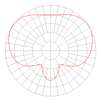 | ||||||||||||||||||
| Azimuth | Ratio | Azimuth | Ratio | Azimuth | Ratio | Azimuth | Ratio | ||||||||||||
| 0 | 0.776 | 10 | 0.794 | 20 | 0.841 | 30 | 0.903 | ||||||||||||
| 40 | 0.960 | 50 | 0.995 | 55 | 1.000 | 60 | 0.997 | ||||||||||||
| 70 | 0.972 | 80 | 0.933 | 90 | 0.890 | 100 | 0.842 | ||||||||||||
| 110 | 0.773 | 120 | 0.667 | 130 | 0.526 | 140 | 0.399 | ||||||||||||
| 145 | 0.373 | 150 | 0.387 | 160 | 0.495 | 170 | 0.608 | ||||||||||||
| 180 | 0.652 | 190 | 0.608 | 200 | 0.496 | 210 | 0.387 | ||||||||||||
| 215 | 0.372 | 220 | 0.397 | 230 | 0.521 | 240 | 0.661 | ||||||||||||
| 250 | 0.767 | 260 | 0.837 | 270 | 0.886 | 280 | 0.930 | ||||||||||||
| 290 | 0.969 | 300 | 0.994 | 305 | 0.996 | 310 | 0.991 | ||||||||||||
| 320 | 0.956 | 330 | 0.899 | 340 | 0.837 | 350 | 0.792 | ||||||||||||
Structure Registration Number 1054347 Structure Type: GTOWER Registered To: American Towers LLC Structure Address: 2416 74th St (30483) Lubbock, TX County Name: Lubbock County ASR Issued: 12/10/2013 Date Built: 07/06/1998 Site Elevation: 984.2 m (3229 ft.) Structure Height: 255.1 m (837 ft.) Height Overall: 279.5 m (917 ft.) Overall Height AMSL: 1263.7 m (4146 ft.) FAA Determination: 12/05/2013 FAA Study #: 2013-ASW-7799-OE FAA Circular #: 70/7460-1K Paint & Light FAA Chapters: 3, 4, 5, 12 PRIOR STUDY 2011-ASW-2183-OE 33-31-33.8 N 101-52-08.6 W (NAD 83) 33-31-33.5 N 101-52-07.0 W (Converted to NAD 27) |
4822 Kemp Boulevard Suite 300 Witchita Falls, TX 76308 Phone: 940-228-7861 Corporation | Title: President Date: 03/11/2022 Application Certifier Mission Broadcasting, Inc. 901 Indiana Ave Suite 375 Witchita Falls, TX 76301 Applicant William T. Godfrey, Jr Kessler And Gehman Associates, Inc. Kessler And Gehman Associates, Inc. 507-d Nw 60th Street Gainesville, FL 32607-2055 Consulting Engineers Gregory L. Masters, Esq Wiley Rein Llp 2050 M Street, N.w. Washington, DC 20036 | |||||||||||||||||
| |||||||||||||||||||