
FCCInfo.com
A Service of Cavell, Mertz & Associates, Inc.
(855) FCC-INFO
|
|
KQAF-LD from 10/06/1993 |
|
|
||||||||||||||||
|
|
Status: License Application Accepted: 03/14/2022 License Expires: 04/01/2022 File Number: -0000186640 FCC Website Links: LMS Facility Details This Application Other KQAF-LD Applications Including Superseded Applications Mailing Address Correspondence for KQAF-LD Correspondence related to application -0000186640 Service Contour - Open Street Map or USGS Map (51 dBu) Service Contour - KML / Google Earth (51 dBu) Rabbit Ears Info Search for KQAF-LD Site Location: 38-10-35.0 N 104-01-25.0 W (NAD 83) Site Location: 38-10-35.0 N 104-01-23.1 W (Converted to NAD 27) ERP: 15 kW Polarization: Horizontally polarized R/C AGL: 80 m (262 ft.) R/C AMSL: 1484.5 m (4870 ft.) Emission Mask: Stringent Site Elevation: 1404.5 m. (4608 ft.) Height Overall*: 86.2 m (283 ft.) (* As Filed In This Application, may differ from ASR Data, Below.) Directional Antenna - Antenna Make/Model: Scala PR-450 ARRAY Antenna ID: 110852 Polarization: Horizontally polarized
| ||||||||||||||||||
| Antenna Data for Antenna Id: 110852 KQAF-LD LD File: -0000186640 Scala - PR-450 ARRAY Service: LD Standard Pattern: Y Pattern and Field Values Include a 120° Clockwise Rotation | 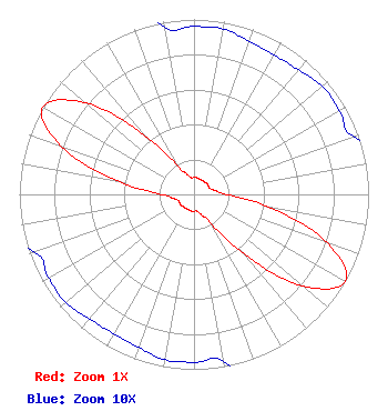 | ||||||||||||||||||
| Azimuth | Ratio | Azimuth | Ratio | Azimuth | Ratio | Azimuth | Ratio | ||||||||||||
| 0 | 0.096 | 10 | 0.096 | 20 | 0.093 | 30 | 0.092 | ||||||||||||
| 40 | 0.093 | 50 | 0.096 | 60 | 0.096 | 70 | 0.097 | ||||||||||||
| 80 | 0.125 | 90 | 0.190 | 100 | 0.447 | 110 | 0.814 | ||||||||||||
| 120 | 1.000 | 130 | 0.814 | 140 | 0.447 | 150 | 0.190 | ||||||||||||
| 160 | 0.125 | 170 | 0.097 | 180 | 0.096 | 190 | 0.096 | ||||||||||||
| 200 | 0.093 | 210 | 0.092 | 220 | 0.093 | 230 | 0.096 | ||||||||||||
| 240 | 0.096 | 250 | 0.097 | 260 | 0.125 | 270 | 0.190 | ||||||||||||
| 280 | 0.447 | 290 | 0.814 | 300 | 1.000 | 310 | 0.814 | ||||||||||||
| 320 | 0.447 | 330 | 0.190 | 340 | 0.125 | 350 | 0.097 | ||||||||||||
Structure Registration Number 1057610 Structure Type: TOWER Registered To: TRI-STATE GENERATION & TRANSMISSION ASSOCIATION INC. Structure Address: 5.3 Km North Of Fowler, CO County Name: Crowley County ASR Issued: 11/02/1998 Date Built: 01/30/1995 Site Elevation: 1404.5 m (4608 ft.) Structure Height: 85.3 m (280 ft.) Height Overall: 86.2 m (283 ft.) Overall Height AMSL: 1490.7 m (4891 ft.) FAA Determination: 01/29/1994 FAA Study #: 94-ANM-0053-OE FAA Circular #: 70/7460-1H Paint & Light FAA Chapters: 3, 4, 5, 13 38-10-35.0 N 104-01-25.0 W (NAD 83) 38-10-35.0 N 104-01-23.1 W (Converted to NAD 27) |
Po Box 1471 29833 Ruby Ranch Road Evergreen, CO 80439 Phone: 907-227-9195 Limited Liability Company | Title: Manager Date: 03/14/2022 Application Certifier Denver Digital Television, Llc Po Box 1471 29833 Ruby Ranch Road Evergreen, CO 80439 Applicant James Talens Denver Digital Television, Llc 6017 Woodley Rd 29833 Ruby Ranch Road Mclean, VA 22101 Attorney | |||||||||||||||||