
FCCInfo.com
A Service of Cavell, Mertz & Associates, Inc.
(855) FCC-INFO
|
|
KOFY-TV from 09/14/1998 KOFY-TV from 03/01/1986 KOFY-TV from 09/21/1980 KOFY-TV from 08/30/1979 |
RF spectrum relinquished in the spectrum auction Virtual Channel 20 |  |
|
||||||||||||||||||
|
|
KOFY-TV is a channel sharing guest of KCNZ-CD, San Francisco, California Repacking Information: Channel 19 was relinquished in the spectrum auction Status: License Application Accepted: 03/11/2022 License Expires: 12/01/2022 File Number: -0000186488 FCC Website Links: LMS Facility Details This Application Other KOFY-TV Applications Including Superseded Applications Mailing Address Correspondence for KOFY-TV Correspondence related to application -0000186488 Service Contour - Open Street Map or USGS Map (41 dBu) Service Contour - KML / Google Earth (41 dBu) Public Inspection Files History Cards for KOFY-TV Rabbit Ears Info Search for KOFY-TV Site Location: 37-41-12.3 N 122-26-07.3 W (NAD 83) Site Location: 37-41-12.5 N 122-26-03.4 W (Converted to NAD 27) ERP: 15 kW Polarization: Circularly polarized Electrical Beam Tilt: 1.0 degree R/C AGL: 59.4 m (195 ft.) R/C AMSL: 449.5 m (1475 ft.) Emission Mask: Full Service Site Elevation: 390.1 m. (1280 ft.) Height Overall*: 78.3 m (257 ft.) (* As Filed In This Application, may differ from ASR Data, Below.) Directional Antenna - Antenna Make/Model: R.F. Systems PEPL5U-CM4 Antenna ID: 1007132 Polarization: Circularly polarized | |||||||||||||||||||||
| Antenna Data for Antenna Id: 1007132 KOFY-TV DT File: -0000186488 R.F. Systems - PEPL5U-CM4 Service: DT Standard Pattern: Y Pattern and Field Values Include a 3° Clockwise Rotation | 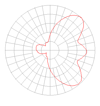 | |||||||||||||||||||||
| Azimuth | Ratio | Azimuth | Ratio | Azimuth | Ratio | Azimuth | Ratio | |||||||||||||||
| 3 | 0.387 | 13 | 0.575 | 23 | 0.758 | 33 | 0.917 | |||||||||||||||
| 43 | 0.999 | 44 | 1.000 | 53 | 0.938 | 63 | 0.765 | |||||||||||||||
| 73 | 0.646 | 83 | 0.739 | 93 | 0.819 | 103 | 0.735 | |||||||||||||||
| 113 | 0.656 | 123 | 0.800 | 133 | 0.952 | 138 | 0.978 | |||||||||||||||
| 143 | 0.969 | 153 | 0.871 | 163 | 0.712 | 173 | 0.544 | |||||||||||||||
| 183 | 0.381 | 193 | 0.244 | 203 | 0.166 | 213 | 0.155 | |||||||||||||||
| 223 | 0.130 | 231 | 0.106 | 233 | 0.110 | 243 | 0.180 | |||||||||||||||
| 253 | 0.245 | 263 | 0.280 | 273 | 0.307 | 283 | 0.315 | |||||||||||||||
| 293 | 0.293 | 303 | 0.215 | 313 | 0.143 | 315 | 0.139 | |||||||||||||||
| 323 | 0.163 | 333 | 0.188 | 343 | 0.177 | 353 | 0.231 | |||||||||||||||
Structure Registration Number 1010566 Structure Type: LTOWER Registered To: American Towers LLC Structure Address: 700 Radio Rd (san Bruno Mtn T9 #8250) Daly City, CA County Name: San Mateo County ASR Issued: 02/04/2015 Date Built: 01/01/1956 Site Elevation: 390.1 m (1280 ft.) Structure Height: 61.3 m (201 ft.) Height Overall: 78.3 m (257 ft.) Overall Height AMSL: 468.4 m (1537 ft.) FAA Determination: 11/06/2014 FAA Study #: 2014-AWP-8134-OE FAA Circular #: 70/7460-1K Paint & Light FAA Chapters: 3, 4, 5, 12 PRIOR STUDY 2012-AWP-861-OE 37-41-12.3 N 122-26-07.3 W (NAD 83) 37-41-12.5 N 122-26-03.4 W (Converted to NAD 27) |
Po Box 1756 Pacific Palisades, CA 90272 Phone: 310-753-1600 Limited Liability Company | Application Certifier Kbwb License Llc C/o Granite Broadcasting Llc 750 Third Avenue, 9th Floor New York, NY 10017 Applicant Christina H Burrow Cooley Llp 1299 Pennsylvania Avenue, Nw Suite 700 Washington, DC 20004 Legal Representative | ||||||||||||||||||||
| ||||||||||||||||||||||