
FCCInfo.com
A Service of Cavell, Mertz & Associates, Inc.
(855) FCC-INFO
|
|
KQRM-LD from 04/15/2007 KQRM-LD from 11/16/2004 |
Virtual Channel 18 |
|
||||||||||||||||
|
|
KQRM-LD is a channel sharing guest of KCNZ-CD, San Francisco, California Status: License Application Accepted: 03/11/2022 License Expires: 12/01/2022 File Number: -0000186489 FCC Website Links: LMS Facility Details This Application Other KQRM-LD Applications Including Superseded Applications Mailing Address Correspondence for KQRM-LD Correspondence related to application -0000186489 Service Contour - Open Street Map or USGS Map (51 dBu) Service Contour - KML / Google Earth (51 dBu) Rabbit Ears Info Search for KQRM-LD Site Location: 37-41-12.3 N 122-26-07.3 W (NAD 83) Site Location: 37-41-12.5 N 122-26-03.4 W (Converted to NAD 27) ERP: 15 kW Polarization: Circularly polarized Electrical Beam Tilt: 1.0 degree R/C AGL: 59.4 m (195 ft.) R/C AMSL: 449.5 m (1475 ft.) Emission Mask: Full Service Site Elevation: 390.1 m. (1280 ft.) Height Overall*: 78.3 m (257 ft.) (* As Filed In This Application, may differ from ASR Data, Below.) Directional Antenna - Antenna Make/Model: R.F. Systems PEPL5U-CM4 Antenna ID: 1007132 Polarization: Circularly polarized | ||||||||||||||||||
| Antenna Data for Antenna Id: 1007132 KQRM-LD LD File: -0000186489 R.F. Systems - PEPL5U-CM4 Service: LD Standard Pattern: Y Pattern and Field Values Include a 3° Clockwise Rotation | 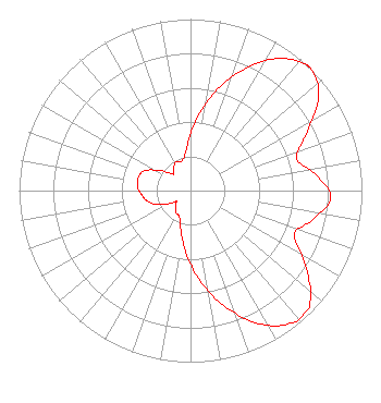 | ||||||||||||||||||
| Azimuth | Ratio | Azimuth | Ratio | Azimuth | Ratio | Azimuth | Ratio | ||||||||||||
| 3 | 0.387 | 13 | 0.575 | 23 | 0.758 | 33 | 0.917 | ||||||||||||
| 43 | 0.999 | 44 | 1.000 | 53 | 0.938 | 63 | 0.765 | ||||||||||||
| 73 | 0.646 | 83 | 0.739 | 93 | 0.819 | 103 | 0.735 | ||||||||||||
| 113 | 0.656 | 123 | 0.800 | 133 | 0.952 | 138 | 0.978 | ||||||||||||
| 143 | 0.969 | 153 | 0.871 | 163 | 0.712 | 173 | 0.544 | ||||||||||||
| 183 | 0.381 | 193 | 0.244 | 203 | 0.166 | 213 | 0.155 | ||||||||||||
| 223 | 0.130 | 231 | 0.106 | 233 | 0.110 | 243 | 0.180 | ||||||||||||
| 253 | 0.245 | 263 | 0.280 | 273 | 0.307 | 283 | 0.315 | ||||||||||||
| 293 | 0.293 | 303 | 0.215 | 313 | 0.143 | 315 | 0.139 | ||||||||||||
| 323 | 0.163 | 333 | 0.188 | 343 | 0.177 | 353 | 0.231 | ||||||||||||
Structure Registration Number 1010566 Structure Type: LTOWER Registered To: American Towers LLC Structure Address: 700 Radio Rd (san Bruno Mtn T9 #8250) Daly City, CA County Name: San Mateo County ASR Issued: 02/04/2015 Date Built: 01/01/1956 Site Elevation: 390.1 m (1280 ft.) Structure Height: 61.3 m (201 ft.) Height Overall: 78.3 m (257 ft.) Overall Height AMSL: 468.4 m (1537 ft.) FAA Determination: 11/06/2014 FAA Study #: 2014-AWP-8134-OE FAA Circular #: 70/7460-1K Paint & Light FAA Chapters: 3, 4, 5, 12 PRIOR STUDY 2012-AWP-861-OE 37-41-12.3 N 122-26-07.3 W (NAD 83) 37-41-12.5 N 122-26-03.4 W (Converted to NAD 27) |
15200 Sunset Boulevard Suite 202 Pacific Palisades, CA 90272 Phone: 310-573-1600 Not-for-Profit | Application Certifier HC2 STATION GROUP, INC. Hc2 Station Group, Inc. 450 Park Avenue 30th Floor New York, NY 10022 Applicant RENEE ILHARDT Hc2 Broadcasting Holdings, Inc. 450 Park Ave 30th Fl New York, NY 10022 | |||||||||||||||||