
FCCInfo.com
A Service of Cavell, Mertz & Associates, Inc.
(855) FCC-INFO
|
|
W30BU-D from 09/28/1998 |
|
|
||||||||||||||||
|
|
Status: STA – Special Temporary Authority Application Accepted: 04/07/2022 STA Expires: 07/11/2022 File Number: -0000179209 FCC Website Links: LMS Facility Details This Application Other W30BU-D Applications Including Superseded Applications Mailing Address Correspondence for W30BU-D Correspondence related to application -0000179209 Service Contour - Open Street Map or USGS Map (74 dBu) Service Contour - KML / Google Earth (74 dBu) Rabbit Ears Info Search for W30BU-D Site Location: 44-21-33.3 N 87-59-08.7 W (NAD 83) Site Location: 44-21-33.3 N 87-59-08.3 W (Converted to NAD 27) ERP: 14.7 kW R/C AGL: 140 m (459 ft.) R/C AMSL: 430.5 m (1412 ft.) Site Elevation: 290.5 m. (953 ft.) Height Overall*: 317 m (1040 ft.) (* As Filed In This Application, may differ from ASR Data, Below.) Directional Antenna - Antenna Make/Model: Andrew ALP12L2-HSP Antenna ID: 16390 | ||||||||||||||||||
| Antenna Data for Antenna Id: 16390 W30BU-D TX File: -0000179209 Andrew - ALP12L2-HSP Service: TX Standard Pattern: Y Pattern and Field Values Include a 20° Clockwise Rotation | 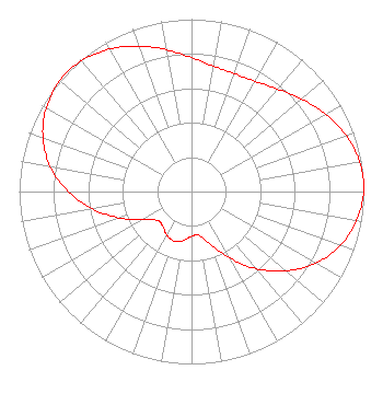 | ||||||||||||||||||
| Azimuth | Ratio | Azimuth | Ratio | Azimuth | Ratio | Azimuth | Ratio | ||||||||||||
| 0 | 0.777 | 10 | 0.738 | 20 | 0.728 | 30 | 0.738 | ||||||||||||
| 40 | 0.777 | 50 | 0.835 | 60 | 0.898 | 70 | 0.954 | ||||||||||||
| 80 | 0.992 | 90 | 0.999 | 100 | 0.973 | 110 | 0.918 | ||||||||||||
| 120 | 0.832 | 130 | 0.716 | 140 | 0.584 | 150 | 0.446 | ||||||||||||
| 160 | 0.326 | 170 | 0.259 | 180 | 0.260 | 190 | 0.289 | ||||||||||||
| 200 | 0.305 | 210 | 0.289 | 220 | 0.260 | 230 | 0.259 | ||||||||||||
| 240 | 0.326 | 250 | 0.446 | 260 | 0.584 | 270 | 0.716 | ||||||||||||
| 280 | 0.832 | 290 | 0.918 | 300 | 0.973 | 310 | 0.999 | ||||||||||||
| 320 | 0.992 | 330 | 0.954 | 340 | 0.898 | 350 | 0.835 | ||||||||||||
Structure Registration Number 1037793 Structure Type: GTOWER Registered To: Woodward Communications Inc. Structure Address: 3237 Shirley Road Depere, WI County Name: Brown County ASR Issued: 10/28/2019 Date Built: 02/02/2016 Site Elevation: 290.5 m (953 ft.) Structure Height: 290.4 m (953 ft.) Height Overall: 317 m (1040 ft.) Overall Height AMSL: 607.5 m (1993 ft.) FAA Determination: 12/22/2015 FAA Study #: 2015-AGL-16888-OE FAA Circular #: 70/7460-1L Paint & Light FAA Chapters: 4, 9, 12 FAA CHAPTERS 4,9,12; 70/746-1L WITH FAA APPROVED BIRD DEVIATION SPECIAL CONDITION.PRIOR STUDY 2003-AGL-6894-OE. OM&L TO REMAIN THE SAME AS PRIOR STUDY = DUAL HIGH INTENSITY 44-21-33.3 N 87-59-08.7 W (NAD 83) 44-21-33.3 N 87-59-08.3 W (Converted to NAD 27) |
Hurst, TX 76054 Phone: 214-770-7770 Corporation | Title: President Date: 04/07/2022 Application Certifier EDGE SPECTRUM, INC. Edge Spectrum, Inc. Hurst, TX 76054 Applicant Caleb Weiss Ark Multicasting, Inc. Cedar Hill, TX 75106 President Randy Weiss Edge Spectrum, Inc. Hurst, TX 76054 CEO Ari Meltzer Wiley Rein Llp 2050 M Street, Nw Washington, DC 20036 Susan Hansen B. W. St. Clair 2305 Vida Shaw Rd. New Iberia, LA 70563 Consultant | |||||||||||||||||