
FCCInfo.com
A Service of Cavell, Mertz & Associates, Inc.
(855) FCC-INFO
|
|
W39CV-D from 05/31/1990 |
|
|
||||||||||||||||
|
|
Status: STA – Special Temporary Authority (Licensed And Silent) Application Accepted: 04/07/2022 STA Expires: 09/06/2022 File Number: -0000178207 FCC Website Links: LMS Facility Details This Application Other W39CV-D Applications Including Superseded Applications Mailing Address Correspondence for W39CV-D Correspondence related to application -0000178207 Service Contour - Open Street Map or USGS Map (51 dBu) Service Contour - KML / Google Earth (51 dBu) Rabbit Ears Info Search for W39CV-D Site Location: 45-53-04.8 N 89-46-50.5 W (NAD 83) Site Location: 45-53-05.0 N 89-46-50.0 W (Converted to NAD 27) ERP: 2.3 kW R/C AGL: 69 m (226 ft.) R/C AMSL: 544.5 m (1786 ft.) Emission Mask: Stringent Site Elevation: 475.5 m. (1560 ft.) Height Overall*: 71.6 m (235 ft.) (* As Filed In This Application, may differ from ASR Data, Below.) Directional Antenna - Antenna Make/Model: Scala SL-8 Antenna ID: 23503 | ||||||||||||||||||
| Antenna Data for Antenna Id: 23503 W39CV-D LD File: -0000178207 Scala - SL-8 Service: LD Standard Pattern: Y | 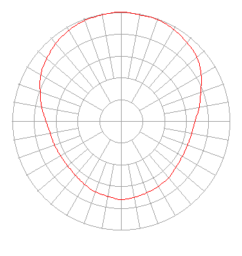 | ||||||||||||||||||
| Azimuth | Ratio | Azimuth | Ratio | Azimuth | Ratio | Azimuth | Ratio | ||||||||||||
| 0 | 1.000 | 10 | 0.990 | 20 | 0.990 | 30 | 0.970 | ||||||||||||
| 40 | 0.940 | 50 | 0.910 | 60 | 0.850 | 70 | 0.780 | ||||||||||||
| 80 | 0.730 | 90 | 0.680 | 100 | 0.660 | 110 | 0.650 | ||||||||||||
| 120 | 0.650 | 130 | 0.660 | 140 | 0.680 | 150 | 0.690 | ||||||||||||
| 160 | 0.700 | 170 | 0.710 | 180 | 0.720 | 190 | 0.700 | ||||||||||||
| 200 | 0.690 | 210 | 0.670 | 220 | 0.650 | 230 | 0.640 | ||||||||||||
| 240 | 0.640 | 250 | 0.650 | 260 | 0.660 | 270 | 0.690 | ||||||||||||
| 280 | 0.740 | 290 | 0.790 | 300 | 0.850 | 310 | 0.890 | ||||||||||||
| 320 | 0.930 | 330 | 0.960 | 340 | 0.980 | 350 | 0.990 | ||||||||||||
Structure Registration Number 1221063 Structure Type: TOWER Structure Address: 8974 Pink Hurst Dr Minocqua, WI County Name: Oneida County ASR Issued: 12/29/2000 Site Elevation: 475.5 m (1560 ft.) Structure Height: 71 m (233 ft.) Height Overall: 71.6 m (235 ft.) Overall Height AMSL: 547.1 m (1795 ft.) FAA Determination: 12/03/1987 FAA Study #: 87-AGL-1596-OE FAA Circular #: 70/7460-1G Paint & Light FAA Chapters: 3, 4, 5, 9 45-53-04.8 N 89-46-50.5 W (NAD 83) 45-53-05.0 N 89-46-50.0 W (Converted to NAD 27) |
Hurst, TX 76054 Phone: 214-770-7770 Corporation | Title: President Date: 04/07/2022 Application Certifier EDGE SPECTRUM, INC. Edge Spectrum, Inc. Hurst, TX 76054 Applicant Caleb Weiss Ark Multicasting, Inc. Cedar Hill, TX 75106 President Randy Weiss Edge Spectrum, Inc. Hurst, TX 76054 CEO Ari Meltzer Wiley Rein Llp 2050 M Street, Nw Washington, DC 20036 Susan Hansen B. W. St. Clair 2305 Vida Shaw Rd. New Iberia, LA 70563 Consultant | |||||||||||||||||