
FCCInfo.com
A Service of Cavell, Mertz & Associates, Inc.
(855) FCC-INFO
|
|
KSFZ-LD from 04/29/1988 |
|
|
|||||||||||||||||
|
|
Status: Construction Permit Application Accepted: 05/05/2022 KSFZ-LD CP Expires: 01/11/2024 File Number: -0000190129 FCC Website Links: LMS Facility Details This Application Other KSFZ-LD Applications Including Superseded Applications Mailing Address Correspondence for KSFZ-LD Correspondence related to application -0000190129 Service Contour - Open Street Map or USGS Map (51 dBu) Service Contour - KML / Google Earth (51 dBu) Rabbit Ears Info Search for KSFZ-LD Site Location: 37-00-22.9 N 93-13-23.1 W (NAD 83) Site Location: 37-00-22.7 N 93-13-22.4 W (Converted to NAD 27) ERP: 15 kW Polarization: Horizontally polarized Electrical Beam Tilt: 0.75 degrees R/C AGL: 81.7 m (268 ft.) R/C AMSL: 469.7 m (1541 ft.) Emission Mask: Full Service Site Elevation: 388 m. (1273 ft.) Height Overall*: 96.6 m (317 ft.) (* As Filed In This Application, may differ from ASR Data, Below.) Directional Antenna - Antenna Make/Model: Propagation System Inc PSILP8EC Antenna ID: 1009549 Polarization: Horizontally polarized
| |||||||||||||||||||
| Antenna Data for Antenna Id: 1009549 KSFZ-LD LD File: -0000190129 Propagation System Inc - PSILP8EC Service: LD Standard Pattern: N Pattern and Field Values Include a 343.0° Clockwise Rotation | 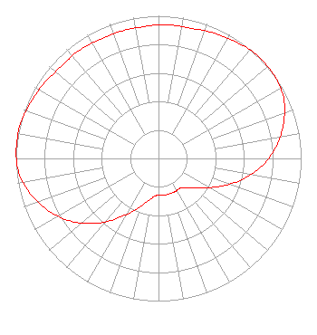 | |||||||||||||||||||
| Azimuth | Ratio | Azimuth | Ratio | Azimuth | Ratio | Azimuth | Ratio | |||||||||||||
| 3 | 0.940 | 13 | 0.940 | 23 | 0.960 | 33 | 0.980 | |||||||||||||
| 43 | 1.000 | 53 | 1.000 | 63 | 0.980 | 73 | 0.920 | |||||||||||||
| 83 | 0.840 | 93 | 0.740 | 103 | 0.620 | 113 | 0.490 | |||||||||||||
| 123 | 0.380 | 133 | 0.300 | 143 | 0.260 | 153 | 0.260 | |||||||||||||
| 163 | 0.260 | 173 | 0.260 | 183 | 0.260 | 193 | 0.300 | |||||||||||||
| 203 | 0.380 | 213 | 0.490 | 223 | 0.620 | 233 | 0.740 | |||||||||||||
| 243 | 0.840 | 253 | 0.920 | 263 | 0.980 | 273 | 1.000 | |||||||||||||
| 283 | 1.000 | 293 | 0.980 | 303 | 0.960 | 313 | 0.940 | |||||||||||||
| 323 | 0.940 | 333 | 0.930 | 343 | 0.930 | 353 | 0.930 | |||||||||||||
Structure Registration Number 1216168 Structure Type: TOWER Registered To: SpectraSite Communications, LLC. through American Towers, LLC. Structure Address: Rt. F And 17th Street (306160) Ozark, MO County Name: Christian County ASR Issued: 01/16/2013 Date Built: 09/28/2000 Site Elevation: 388 m (1273 ft.) Structure Height: 92 m (302 ft.) Height Overall: 96.6 m (317 ft.) Overall Height AMSL: 484.6 m (1590 ft.) FAA Determination: 09/21/2004 FAA Study #: 2004-ACE-1812-OE FAA Circular #: 70/7460-1K Paint & Light FAA Chapters: 4, 8, 12 PRIOR STUDY 2000-ACE-768-OE 37-00-22.9 N 93-13-23.1 W (NAD 83) 37-00-22.7 N 93-13-22.4 W (Converted to NAD 27) |
Po Box 11409 Chattanooga, TN 37401 Phone: 423-468-5100 Limited Liability Company | Title: Coo Date: 05/05/2022 Application Certifier Digital Networks-midwest, Llc Chattanooga, TN 37401 Applicant Timothy Z Sawyer T Z Sawyer Technical Consultants 2130 Hutchison Grove Court Suite 100 Falls Church, VA 22043 Technical Consultant Aaron P Shainis, Esq Shainis & Peltzman, Chartered 1850 M Street Nw Suite 240 Washington, DC 20036 Legal Counsel | ||||||||||||||||||