
FCCInfo.com
A Service of Cavell, Mertz & Associates, Inc.
(855) FCC-INFO
|
|
|
Virtual Channel 3 |
|
|||||||||||||||||||
|
|
Status: License Application Accepted: 05/12/2022 License Expires: 10/03/2022 File Number: -0000190598 FCC Website Links: LMS Facility Details This Application Other KUTA-LD Applications Including Superseded Applications Mailing Address Correspondence for KUTA-LD Correspondence related to application -0000190598 Service Contour - Open Street Map or USGS Map (48 dBu) Service Contour - KML / Google Earth (48 dBu) Rabbit Ears Info Search for KUTA-LD Site Location: 41-09-57.0 N 112-00-55.0 W (NAD 83) Site Location: 41-09-57.2 N 112-00-52.2 W (Converted to NAD 27) ERP: 1 kW Polarization: Horizontally polarized R/C AGL: 22.2 m (73 ft.) R/C AMSL: 1416.9 m (4649 ft.) Emission Mask: Full Service Site Elevation: 1394.7 m. (4576 ft.) Height Overall*: 25.6 m (84 ft.) (* As Filed In This Application, may differ from ASR Data, Below.) Directional Antenna - Antenna Make/Model: Scala CL-713 Array Antenna ID: 1009572 Polarization: Horizontally polarized
| |||||||||||||||||||||
| Antenna Data for Antenna Id: 1009572 KUTA-LD LD File: -0000190598 Scala - CL-713 Array Service: LD Standard Pattern: N | 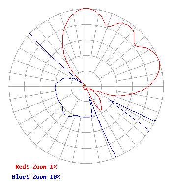 | |||||||||||||||||||||
| Azimuth | Ratio | Azimuth | Ratio | Azimuth | Ratio | Azimuth | Ratio | |||||||||||||||
| 0 | 1.000 | 10 | 0.946 | 20 | 0.827 | 30 | 0.941 | |||||||||||||||
| 40 | 0.941 | 50 | 0.827 | 60 | 0.946 | 70 | 1.000 | |||||||||||||||
| 80 | 0.946 | 90 | 0.807 | 100 | 0.602 | 110 | 0.359 | |||||||||||||||
| 120 | 0.040 | 130 | 0.200 | 140 | 0.300 | 150 | 0.350 | |||||||||||||||
| 160 | 0.040 | 170 | 0.040 | 180 | 0.040 | 190 | 0.040 | |||||||||||||||
| 200 | 0.040 | 210 | 0.045 | 220 | 0.045 | 230 | 0.040 | |||||||||||||||
| 240 | 0.040 | 250 | 0.040 | 260 | 0.040 | 270 | 0.040 | |||||||||||||||
| 280 | 0.035 | 290 | 0.030 | 300 | 0.020 | 310 | 0.040 | |||||||||||||||
| 320 | 0.359 | 330 | 0.602 | 340 | 0.807 | 350 | 0.946 | |||||||||||||||
Structure Registration Number 1058818 Structure Type: TOWER Registered To: AIRWAVES TOWER COMPANY Structure Address: 5440s 1700w Riverdale, UT County Name: Weber County ASR Issued: 12/15/1998 Date Built: 08/15/1998 Site Elevation: 1394.7 m (4576 ft.) Structure Height: 25.6 m (84 ft.) Height Overall: 25.6 m (84 ft.) Overall Height AMSL: 1420.3 m (4660 ft.) FAA Determination: 07/16/1997 FAA Study #: 97-ANM-0482-OE Paint & Light FAA Chapters: NONE 41-09-57.0 N 112-00-55.0 W (NAD 83) 41-09-57.2 N 112-00-52.2 W (Converted to NAD 27) |
453 Simoron Drive Ogden, UT 84404 Phone: 801-399-0012 Corporation | Title: President Date: 05/12/2022 Application Certifier AIRWAVES, INC. Airwaves, Inc. 453 Simoron Drive Ogden, UT 84404 Applicant Michael Couzens Michael Couzens Law Office Oakland, CA 94609 John Terrill Airwaves 453 Simoron Drive Ogden, UT 84404 | ||||||||||||||||||||