
FCCInfo.com
A Service of Cavell, Mertz & Associates, Inc.
(855) FCC-INFO
|
|
KYTL-LD from 12/11/2012 KYTL-LD from 01/30/2006 KYTL-LD from 08/26/2005 |
|
|
||||||||||||||||
|
|
Status: License Application Accepted: 05/12/2022 License Expires: 10/03/2022 File Number: -0000190564 FCC Website Links: LMS Facility Details This Application Other KYTL-LD Applications Including Superseded Applications Mailing Address Correspondence for KYTL-LD Correspondence related to application -0000190564 Service Contour - Open Street Map or USGS Map (51 dBu) Service Contour - KML / Google Earth (51 dBu) Rabbit Ears Info Search for KYTL-LD Site Location: 42-43-44.0 N 114-24-59.0 W (NAD 83) Site Location: 42-43-44.3 N 114-24-55.9 W (Converted to NAD 27) ERP: 15 kW Polarization: Horizontally polarized R/C AGL: 43 m (141 ft.) R/C AMSL: 1345 m (4413 ft.) Emission Mask: Full Service Site Elevation: 1302 m. (4272 ft.) Height Overall*: 46.6 m (153 ft.) (* As Filed In This Application, may differ from ASR Data, Below.) Directional Antenna - Antenna Make/Model: Kathrein K723147 Antenna ID: 107268 Polarization: Horizontally polarized | ||||||||||||||||||
| Antenna Data for Antenna Id: 107268 KYTL-LD LD File: -0000190564 Kathrein - K723147 Service: LD Standard Pattern: Y | 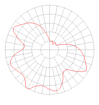 | ||||||||||||||||||
| Azimuth | Ratio | Azimuth | Ratio | Azimuth | Ratio | Azimuth | Ratio | ||||||||||||
| 0 | 0.202 | 10 | 0.182 | 20 | 0.205 | 30 | 0.133 | ||||||||||||
| 40 | 0.205 | 45 | 0.196 | 50 | 0.182 | 60 | 0.202 | ||||||||||||
| 70 | 0.349 | 80 | 0.543 | 90 | 0.679 | 100 | 0.775 | ||||||||||||
| 110 | 0.861 | 120 | 0.941 | 130 | 0.756 | 135 | 0.644 | ||||||||||||
| 140 | 0.576 | 150 | 0.608 | 160 | 0.822 | 170 | 0.933 | ||||||||||||
| 180 | 0.886 | 190 | 0.827 | 200 | 0.866 | 210 | 1.000 | ||||||||||||
| 220 | 0.867 | 225 | 0.832 | 230 | 0.829 | 240 | 0.885 | ||||||||||||
| 250 | 0.934 | 260 | 0.825 | 270 | 0.613 | 280 | 0.577 | ||||||||||||
| 290 | 0.754 | 300 | 0.940 | 310 | 0.861 | 315 | 0.813 | ||||||||||||
| 320 | 0.774 | 330 | 0.678 | 340 | 0.543 | 350 | 0.348 | ||||||||||||
Structure Registration Number 1041029 Structure Type: TOWER Registered To: Christian Broadcasting of Idaho, Inc. Structure Address: Atop Flat Top Butte Jerome, ID County Name: Jerome County ASR Issued: 08/27/2002 Date Built: 04/20/1998 Site Elevation: 1302 m (4272 ft.) Structure Height: 46.6 m (153 ft.) Height Overall: 46.6 m (153 ft.) Overall Height AMSL: 1348.6 m (4425 ft.) FAA Determination: 09/26/1997 FAA Study #: 97-ANM-1135-OE FAA Circular #: 70/7460-1J Paint & Light FAA Chapters: 4, 5, 13 42-43-44.0 N 114-24-59.0 W (NAD 83) 42-43-44.3 N 114-24-55.9 W (Converted to NAD 27) |
Twin Falls, ID 83303 Phone: 701-391-6540 Limited Liability Company | Title: Co-owner Date: 05/12/2022 Application Certifier I84 Broadcasting Company Twin Falls, ID 83303 Applicant Jordan Bitz I84 Broadcasting Company Twin Falls, ID 83303 Co Owner | |||||||||||||||||